Interstate 510: A Vital Spur Route in New Orleans
Located in the eastern reaches of New Orleans, Louisiana, Interstate 510 (I-510) serves as a critical short-distance spur route. Connecting the primary I-10 corridor to the industrial and aerospace hubs of the region, this auxiliary route facilitates essential movement within Orleans Parish.
The highway is a modern evolution of Paris Road, a historic metropolitan roadway dating back to the 19th century that originally stretched from the Mississippi River to Lake Pontchartrain. While the I-510 designation covers a specific segment, the route remains a key artery for the New Orleans East area and the Ninth Ward.
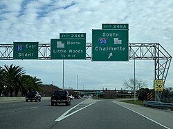
Key Facts
- Total Length: 3.04 miles (4.89 km).
- Parent Route: I-10.
- Maintenance: Managed by the Louisiana Department of Transportation and Development (DOTD).
- Concurrent Route: Runs entirely concurrently with Louisiana Highway 47 (LA 47).
- Primary Destinations: NASA Michoud Assembly Facility and Chalmette.
- Opening Date: November 13, 1992.
Route Description and Connectivity
I-510 begins at its northern terminus at the junction of I-10 and LA 47. From there, it travels south, intersecting with U.S. Route 90 before reaching its southern terminus at the Almonaster Boulevard interchange. This terminus is situated near the NASA Michoud Assembly Facility, a major center for spaceflight hardware.
Beyond the official interstate designation, the highway continues south as Paris Road, crossing the Gulf Intracoastal Waterway and the Mississippi River Gulf Outlet via the Green Bridge. This extension provides a direct link to Chalmette, the seat of St. Bernard Parish.
In addition to supporting industrial traffic, the spur provides access to the site of the former Six Flags New Orleans. Following standard interstate conventions for spur routes, the exits on I-510 are numbered sequentially from the parent route (I-10) toward the remote southern terminus.
Development and History
The path to completing I-510 was a lengthy process. The project was first proposed in 1970 as a necessary replacement for the existing Paris Road. However, the project faced significant delays due to environmental concerns, which required a comprehensive environmental impact statement that was not completed until 1981.
Construction finally began in 1985. The project cost $87 million and took seven years to complete, culminating in an official ribbon-cutting ceremony on November 13, 1992. Interestingly, I-510 was not always intended to be a short spur; it was originally envisioned as part of a much larger loop designated as I-410, which would have integrated I-310 to encircle the southern portion of the New Orleans metropolitan area.
Route Summary
| Feature | Detail |
|---|---|
| Length | 3.04 mi (4.89 km) |
| Jurisdiction | Orleans Parish, Louisiana |
| National Highway System (NHS) | Entire route included |
| Northern Terminus | I-10 / LA 47 |
| Southern Terminus | Almonaster Boulevard / LA 47 |
| Major Intersections | US 90 |
Frequently Asked Questions
What is the primary purpose of Interstate 510?
I-510 serves as a spur route connecting I-10 to the NASA Michoud Assembly Facility and providing a gateway to St. Bernard Parish via the Green Bridge.
How long is the I-510 highway?
The highway is 3.04 miles (4.89 km) long.
Is I-510 the same as Louisiana Highway 47?
Yes, I-510 runs concurrently with LA 47 for its entire length, meaning both designations apply to the same stretch of road.
When did I-510 officially open to traffic?
The highway was officially opened on November 13, 1992, following seven years of construction.
Was I-510 originally planned as a shorter route?
No, it was originally planned as part of a larger proposed loop called I-410, which would have also incorporated I-310 around southern New Orleans.