Huey P. Long Bridge: A Landmark of Engineering and Transit in Louisiana
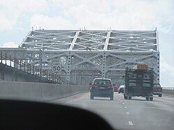
Spanning the mighty Mississippi River in Jefferson Parish, Louisiana, the Huey P. Long Bridge is more than just a transit route; it is a monumental piece of American civil engineering. Located several kilometers upriver from New Orleans, this cantilevered steel through-truss bridge serves as a vital artery, carrying both the New Orleans Public Belt Railroad and US 90. Connecting Elmwood on the East Bank to Bridge City on the West Bank, the bridge stands as a testament to early 20th-century ambition and modern infrastructure evolution.
Opened in December 1935, the bridge was named in honor of the late Governor Huey P. Long. It holds the distinction of being the first Mississippi River span built within Louisiana and is recognized as a National Historic Civil Engineering Landmark by the American Society of Civil Engineers.
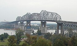
Key Facts
- Location: Jefferson Parish, Louisiana (Mile 106.1 of the Mississippi River).
- Design: Cantilever truss bridge designed by Ralph Modjeski.
- Traffic: Carries 6 lanes of vehicular traffic (US 90) and 2 railroad tracks.
- Dimensions: Road length of 8,076 ft and rail length of 22,996 ft.
- Clearance: 153 ft of vertical clearance for river navigation.
- Daily Volume: Approximately 41,000 vehicles (as of 2023).
Engineering and Structural Design
The bridge is characterized by its massive steel truss system. The widest clear span measures 790 feet, complemented by three additional spans of 530 feet each, creating a total river crossing of approximately 2,400 feet. To accommodate river traffic, the structure provides three navigation channels, the largest of which is 750 feet wide.
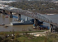
One of the most distinctive features of the bridge is its flat profile. While most bridges of this height feature a "hump," the Huey P. Long Bridge was designed to be unusually flat to facilitate the movement of heavy rail traffic. The rail structure is extensive, stretching 22,996 feet as it extends into the city via viaducts on both banks.
Overcoming "Gumbo Soil"
The foundation of the bridge required innovative engineering due to the local geography. The region is composed of silt deposits and compressible clay topsoil, known locally as gumbo soil, which is unsuitable for heavy foundation loads. Because bedrock is located roughly 1,000 feet below the surface—too deep for traditional piling—engineers seated the main piers on a layer of fine sand 160 to 170 feet below Mean Gulf Level, relying on the sheer size and mass of the piers for stability.
Historical Development
The vision for a high-level crossing began as early as 1892, though economic depressions and the technical challenges of the soil delayed progress for decades. By 1916, a constitutional amendment granted the city of New Orleans the power to build and operate a crossing. After debating between a tunnel, a drawbridge, and a high-level bridge, the War Department rejected the drawbridge as too risky for such critical infrastructure, and the tunnel was deemed to have insufficient capacity.
Design work began in 1925 under the firm Modjeski and Masters. Despite funding hurdles caused by the Great Depression, a complex agreement between the Southern Pacific Railroad, the City of New Orleans, and the State of Louisiana finally secured the necessary bonds in 1932. Construction took three years, costing $13.4 million (approximately $241 million in 2024 dollars).
The $1.2 Billion Widening Project
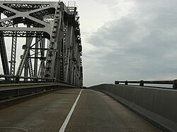
For decades, the bridge was notorious among drivers for its narrow 9-foot lanes and lack of shoulders. To address this, the Louisiana Department of Transportation and Development launched a massive widening project in April 2006 as part of the Transportation Infrastructure Model for Economic Development (TIMED) Program.
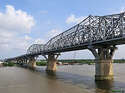
Completed on June 16, 2013, the project transformed the roadway from two narrow lanes in each direction to three 11-foot lanes, complete with inside and outside shoulders. The expansion was executed in four distinct phases:
- Main Support Widening: Strengthening and widening river and land piers.
- Railroad Modifications: Relocating supports to make room for new approaches.
- Main Bridge Widening: Expanding the truss using a combination of "stick-built" and "span-by-span" methods, where pre-assembled sections were lifted into place via barges and strand jacks.
- New Approaches: Constructing new roadway structures and replacing traffic circles with signalized intersections.
Technical Specifications Summary
| Feature | Detail |
|---|---|
| Total Road Length | 8,076 ft (2,462 m) |
| Total Rail Length | 22,996 ft (7,009 m) |
| Longest Span | 790 ft (241 m) |
| Vertical Clearance | 153 ft (47 m) |
| Number of Lanes | 6 (3 in each direction) |
| Rail Tracks | 2 (Standard Gauge) |
| Owner | New Orleans Public Belt Railroad |
Frequently Asked Questions
Is the Huey P. Long Bridge the longest rail bridge in the US?
While it is often described as such due to its massive scale, it is not the longest. The nearby Norfolk Southern Lake Pontchartrain Bridge is considerably longer at 5.8 miles.
Why is the bridge designed to be flat rather than arched?
The bridge was designed with a flat profile specifically to facilitate rail traffic, as steep grades are difficult for heavy trains to navigate.
What is "gumbo soil" and how did it affect construction?
Gumbo soil is a highly compressible clay topsoil found in the New Orleans area. Because it cannot support heavy loads and bedrock is too deep, engineers had to seat the bridge piers on a deep layer of fine sand.
How did the 2013 widening project change the driving experience?
The project increased the number of lanes from two to three in each direction and increased lane width from 9 feet to 11 feet, while adding essential shoulders for safety.
Who maintains the bridge today?
The bridge is maintained by both the Louisiana Department of Transportation and Development and the New Orleans Public Belt Railroad.