Interstate 610: New Orleans' Essential Bypass Route
Interstate 610 (I-610) serves as a critical 4.52-mile auxiliary route of I-10, designed to streamline traffic by bypassing the Central Business District of New Orleans, Louisiana. Maintained by the Louisiana Department of Transportation and Development (DOTD), this urban interstate provides a vital link for commuters and travelers navigating the city's complex geography.
Key Facts
- Total Length: 4.52 miles (7.27 km).
- Classification: Urban Interstate.
- Average Daily Traffic: Between 68,000 and 70,900 vehicles (2013 data).
- Speed Limit: 60 mph (97 km/h).
- Jurisdiction: Spans Jefferson and Orleans Parishes.
- Status: Entire route is part of the National Highway System (NHS).
Route Description and Path
The journey of I-610 begins at the Jefferson–Orleans parish line, marking the boundary between unincorporated Metairie and New Orleans. Starting as a four-lane freeway, it branches off I-10 at exit 230, crossing the 17th Street Canal into the Lakeview neighborhood. While the main I-10 route swings south toward the city center via the Pontchartrain Expressway, I-610 maintains an eastward trajectory.
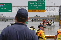
Early in its route, a partial cloverleaf interchange (exit 1A) connects the highway to the one-way couplet of West End and Pontchartrain boulevards, while also facilitating a connection for westbound I-610 traffic to merge onto eastbound I-10. This area also includes a tight diamond interchange with Canal Boulevard, a major north-south thoroughfare.
As the highway widens to six lanes, it parallels the Norfolk Southern Railway line and crosses the Orleans Avenue Drainage Canal, entering City Park. After passing Pan American Stadium and crossing Bayou St. John, the route enters the 7th Ward—which overlaps the Gentilly neighborhood—and becomes an elevated freeway.
The 7th Ward section is served by several key exits: St. Bernard Avenue (2A) and Paris Avenue (2C) form a diamond interchange, followed by a partial interchange with US Highway 90 (exit 2B). Additionally, exit 3 provides access to Louisiana Highway 3021 (Elysian Fields Avenue), a primary artery leading to the University of New Orleans and Dillard University.
Toward its eastern terminus, I-610 returns to a four-lane capacity at the Franklin Avenue interchange (exit 4). The route eventually curves northeast to merge back into I-10, directing through traffic toward New Orleans East and Slidell via Lake Pontchartrain.
Route Summary Table
| Feature | Details |
|---|---|
| Total Distance | 4.52 miles (7.27 km) |
| Primary Function | Bypass of New Orleans Central Business District |
| Major Junctions | I-10, US 90, LA 3021 |
| Parishes Served | Jefferson, Orleans |
| Maintenance | Louisiana DOTD |
History and Legal Challenges
The concept for I-610 emerged around 1956, based on a proposal to build a federal-aid highway alongside an existing railroad. This plan sparked significant public debate during 1958 hearings because the proposed path cut through City Park.
Although the state acquired the right-of-way in 1966 and began construction in 1971, the project faced a legal hurdle in 1972. A lawsuit claimed the highway violated a 1968 law prohibiting the use of parkland for roads unless no alternative existed and mitigation steps were taken. The state eventually won the legal battle, and the highway was completed in the late 1970s.
The route was the site of a major tragedy on May 9, 1999, known as the Mother's Day bus crash. A charter motorcoach carrying 43 passengers veered off the road at milepost 1.6, crashing into a dirt embankment in City Park. The accident resulted in 22 fatalities and 22 injuries, marking the deadliest bus crash in Louisiana's history.
Future Outlook and Proposals
There have been ongoing discussions regarding the removal of I-10 from the Claiborne Expressway. Some proposals suggest renaming I-610 as I-10 and renaming the Pontchartrain Expressway as I-49 or I-910. This movement received support from President Joe Biden in April 2021.
However, a full removal of the expressway is estimated to cost over $4 billion and could potentially increase regional traffic and cause negative economic impacts. In October 2022, the governments of Louisiana and New Orleans proposed a more moderate $94.7 million plan to improve the Claiborne Expressway, enhance the space beneath it, and remove four ramps in the Tremé neighborhood.
Frequently Asked Questions
What is the primary purpose of Interstate 610?
I-610 serves as an auxiliary route to I-10, allowing drivers to bypass the Central Business District of New Orleans.
Which major institutions are accessible via I-610?
Through the Elysian Fields Avenue exit (LA 3021), drivers can access both Dillard University and the University of New Orleans.
What was the legal controversy surrounding the construction of I-610?
The construction was challenged in court because it cut through City Park, which critics argued violated a 1968 law protecting parkland from highway development.
What is the current status of the Claiborne Expressway removal proposal?
While there is presidential backing for removal, recent government proposals focus on a $94.7 million improvement plan rather than full demolition due to high costs (over $4 billion) and potential economic and traffic concerns.
How long is the I-610 route?
The total length of the highway is 4.52 miles (7.27 km).