Imjin River: A Powerful Symbol of Korean History and Geography
Flowing from the mountains of the north to the plains of the south, the Imjin River (known as Rimjin in North Korea) serves as a vital geographical artery for the Korean Peninsula. As the seventh-largest river in Korea, it traverses a landscape marked by both natural beauty and profound historical significance, crossing the Demilitarized Zone (DMZ) before joining the Han River near the Yellow Sea.
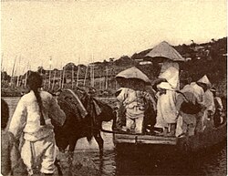
While the river shares a name with the 16th-century Imjin War, it is not actually the namesake of that conflict. However, the river has been a central stage for major military history, serving as the site of two significant battles: the Battle of Imjin River during the Imjin War in 1592, and the Battle of the Imjin River during the Korean War.
Geographical Characteristics and Hydrology
The Imjin River possesses a unique and sometimes deceptive physical profile. Under normal conditions, the active water channel occupies only about 150 to 200 feet of a much wider 1,200-foot (370 m) dry riverbed. This bed is flanked by nearly vertical rock cliffs that rise approximately 75 feet (23 m) above the mean low water level.
Despite its calm appearance in dry periods, the river transforms into a raging torrent during the Korean rainy season in July and August. Fed by mountain streams and larger tributaries, the river can reach flood heights of 48 feet (15 m) above the mean water level, with water velocities reaching 15 to 20 feet per second (6 m/s). Because approximately 95 percent of precipitation runs off rapidly during heavy rains, the river has been known to rise at rates exceeding six feet per hour.
In the winter, the river faces different challenges. Sub-zero temperatures cause thick ice to form, which is often broken up by tidal actions in the lower reaches, leading to large accumulations of floe ice (chunks of floating ice) against obstacles in the channel.
Quick Reference: Imjin River Profile
| Feature | Details |
|---|---|
| Total Length | 273.50 km (169.95 mi) |
| Basin Size | 8,138.90 km² (3,142.45 sq mi) |
| Source | Turyu Mountain, Kangwon Province, North Korea |
| Mouth | Han River, Paju, Gyeonggi Province, South Korea |
| Provinces Covered | Kangwon, North Hwanghae (PRK); Gyeonggi (ROK) |
Inter-Korean Cooperation and the Joint Use Zone
In recent years, the Imjin River has become a focal point for diplomatic and ecological efforts. On November 4, 2018, a joint 20-member team—comprising 10 representatives from North Korea and 10 from South Korea—initiated an inter-Korean survey. The goal was to facilitate the development of a Joint Utilization Zone along the river's estuary.
This proposed zone aims to allow civilians access to the estuary for several purposes:
- Tourism development
- Ecological protection
- Collection of construction aggregate
The project is intended to operate under the protection of militaries from both sides of the border. Following the survey, which concluded on December 9, 2018, a new map detailing newly discovered reefs in the estuary was prepared for public release in early 2019.
Cultural Legacy and the "River of the Dead"
The Imjin River carries a heavy emotional weight in Korean culture. In South Korea, it is sometimes somberly nicknamed the "River of the Dead," a reference to the historical occurrence of bodies floating down from the North, most notably during the major famine of the 1990s.
Conversely, the river is also a symbol of hope and unity in popular music. The famous North Korean song "Rimjingang," composed in 1957 with lyrics by poet Pak Se-yong, depicts the river as a symbol of freedom flowing from north to south. The song expresses the sadness of a divided homeland and has gained popularity among Korean communities worldwide as a symbol of the hope for eventual reunification.
The river has even made appearances in Western popular culture. In the novel MASH: A Novel About Three Army Doctors, the fictional 4077th Mobile Army Surgical Hospital is located near a branch of the Imjin River.
Key Facts
- The Imjin is the seventh-largest river in Korea.
- It flows from Turyu Mountain in North Korea to the Han River in South Korea.
- The riverbed is significantly wider than the active water channel, featuring 75-foot rock cliffs.
- It is a site of major historical conflict, including battles in both the Imjin War and the Korean War.
- A Joint Utilization Zone project was initiated in 2018 to promote tourism and ecological protection.
Frequently Asked Questions
Is the Imjin River the same as the Imjin War?
No. While they share the same name, the river is not the namesake of the 16th-century Japanese invasions known as the Imjin War.
How does the river behave during the rainy season?
The river can become a violent torrent during July and August, with water levels rising up to 48 feet above the mean level and rising as fast as six feet per hour.
What is the significance of the "Rimjingang" song?
It is a well-known North Korean song that uses the river as a symbol of freedom and the longing for a unified, undivided Korean homeland.
Where does the Imjin River end?
The river flows into the Han River near Paju, Gyeonggi Province, in South Korea, eventually reaching the Yellow Sea.
What was the purpose of the 2018 inter-Korean survey?
The survey was conducted to help develop a Joint Utilization Zone at the river's estuary for tourism, ecology, and resource collection.