Hodoyoshi-3 Satellite: Advancing Earth Observation and Space Technology
The Hodoyoshi-3 satellite serves as a sophisticated platform for space-based technology verification. By integrating advanced imaging systems and flexible payload options, the mission aims to push the boundaries of remote sensing and open new avenues for private sector satellite utilization.
Primary Mission: High-Precision Earth Observation
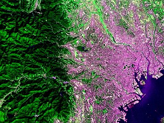
The core objective of Hodoyoshi-3 is the verification of space technology, specifically focusing on two Earth observation cameras. These instruments are designed to capture data at different scales to provide a comprehensive view of the planet's surface.
- Middle Resolution Camera (MCAM): Features a nominal Ground Sample Distance (GSD)—the distance between pixel centers measured on the ground—of 40 meters.
- Low Resolution Camera (LCAM): Features a nominal GSD of 200 meters.
The MCAM is particularly advanced, utilizing a multi-band pass filter to perform spectroscopic observations. It captures data across near-infrared rays, red, and three distinct green bands.
One of the most critical applications of this data is the calculation of the Normalized Difference Vegetation Index (NDVI). By analyzing the relationship between near-infrared rays and the red band, researchers can evaluate the growth and health of trees and agricultural products, enabling broad-based mapping of vegetation indices.
Secondary and Tertiary Objectives
Beyond its primary imaging goals, Hodoyoshi-3 carries out two additional missions designed for environmental monitoring and commercial collaboration.
Flood Monitoring and Water Level Measurement
The satellite utilizes a Store&Forward System to measure water levels in rivers. This capability is essential for monitoring floods, providing critical data that can assist in disaster management and environmental safety.
The Hosted Payload Initiative
To explore new markets in satellite utilization, the mission included a Hosted Payload. This consisted of 10 cm-cubic boxes where external users could install their own specialized apparatuses. To foster private partnerships, project members collaborated with organizations such as the Sanrio corporation.
Key Facts
- Primary Purpose: Space technology verification.
- Imaging Capabilities: Dual cameras with 40m (MCAM) and 200m (LCAM) GSD.
- Spectral Range: MCAM captures near-infrared, red, and three green bands.
- Environmental Application: Uses NDVI for vegetation health and growth mapping.
- Disaster Management: Monitors river water levels via a Store&Forward System.
- Commercial Integration: Provided 10 cm-cubic hosted payload slots for private partners.
| Feature | Specification/Detail |
|---|---|
| MCAM Resolution (GSD) | 40 meters |
| LCAM Resolution (GSD) | 200 meters |
| MCAM Spectral Bands | Near-infrared, Red, 3x Green |
| Vegetation Analysis Tool | NDVI |
| Hosted Payload Size | 10 cm-cubic boxes |
Frequently Asked Questions
What is GSD in the context of the Hodoyoshi-3 cameras?
GSD stands for Ground Sample Distance, which refers to the physical distance on the ground represented by a single pixel in the satellite image. Hodoyoshi-3 uses 40m for its middle resolution camera and 200m for its low resolution camera.
How does the MCAM help in agricultural monitoring?
The MCAM uses a multi-band pass filter to capture near-infrared and red light. This allows for the creation of the Normalized Difference Vegetation Index (NDVI), which is used to assess the soundness and growth levels of crops and forests.
What is the purpose of the Store&Forward System?
The Store&Forward System is used for the satellite's secondary mission: measuring river water levels to monitor and predict floods.
What was the Hosted Payload mission?
The Hosted Payload mission allowed private partners, such as the Sanrio corporation, to install their own equipment in 10 cm-cubic boxes on the satellite to explore new commercial applications for space technology.