SAOCOM: Argentina's Advanced Microwave Earth Observation Constellation
The SAOCOM (Satélite Argentino de Observación Con Microondas) is a sophisticated Earth observation satellite constellation operated by Argentina's space agency, CONAE. Designed to provide critical data for environmental monitoring and disaster mitigation, the system utilizes microwave technology to see through clouds and darkness, providing a reliable eye on the planet's surface.
The project was developed with INVAP serving as the main contractor for the design and construction of the spacecraft and their specialized payloads. The constellation currently consists of two operational satellites, SAOCOM 1A and SAOCOM 1B, both positioned in a Sun-synchronous orbit—a specific type of polar orbit that allows the satellite to pass over any given point of the Earth's surface at the same local solar time.
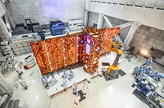
Key Facts
- Operator: CONAE (Argentina)
- Manufacturer: INVAP
- Primary Instrument: L-band Synthetic Aperture Radar (SAR)
- Orbit Type: Sun-synchronous (620 km altitude)
- Launch Vehicle: SpaceX Falcon 9 Block 5
- Mission Duration: 5 years (planned)
- Launch Mass: 3,050 kg per satellite
Technical Configuration and Capabilities
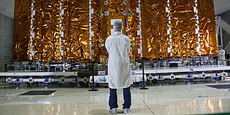
Both SAOCOM 1A and 1B are built on the SAC-C bus (the structural platform of the spacecraft). Their primary tool is a full polarimetric Synthetic Aperture Radar (SAR) operating in the L-band (approximately 1.275 GHz). Unlike optical cameras, SAR emits its own microwave signals and measures the reflection to create high-resolution images of the terrain.
The SAR-L instrument offers various operational modes with resolutions ranging from 7 to 100 meters and swath widths (the width of the strip of terrain imaged) between 50 and 400 kilometers. To handle the massive amount of data generated, each satellite is equipped with a high-capacity Solid State Recorder (50 to 100 Gbits) and two X-band downlink channels capable of transmitting data at 150 Mbits/s each.
Mission History and Launch Logistics
The path to orbit was marked by several delays. Originally targeted for 2012 and 2013, the schedule shifted multiple times before SAOCOM 1A finally launched on October 8, 2018, from Vandenberg Air Force Base. This launch was notable for being SpaceX's first land landing on the Pacific coast at Landing Zone 4.
SAOCOM 1B followed on August 30, 2020, launching from Cape Canaveral (SLC-40). This mission was historically significant as it marked the first use of the southern polar corridor from Cape Canaveral since 1969, requiring the rocket to fly west over Cuba to reach its polar orbit. SAOCOM 1B also carried two rideshare payloads, GNOMES 1 and Tyvak 0172.
The SIASGE Global Partnership
The SAOCOM satellites do not work in isolation. They are part of the SIASGE (Sistema Italo-Argentino de Satélites para la Gestión de Emergencias), an Italian-Argentine System of Satellites for Emergency Management. This constellation combines Argentina's L-band SAR satellites with four X-band (~9.6 GHz) SAR satellites from the Italian Space Agency's (ASI) COSMO-SkyMed constellation.
By integrating L-band and X-band data, the partnership provides a comprehensive monitoring capability with twice-daily coverage, which is essential for rapid emergency response and environmental analysis. Plans to expand SIASGE include adding two more COSMO-SkyMed satellites (CSG-1 and CSG-2) and two additional SAOCOM satellites (2A and 2B, planned for 2028 and 2030), potentially bringing the total constellation to 10 satellites.
| Parameter | Specification |
|---|---|
| Launch Mass | 3,050 kg |
| Dry Mass | 1,600 kg |
| Orbit Altitude | 620 km |
| Inclination | 97.89° |
| Orbital Period | 97.2 minutes |
| Repeat Interval | 16 days |
| Radar Band | L-band (1.275 GHz) |
| Downlink Band | X-band (2 channels) |
Frequently Asked Questions
What is the primary purpose of the SAOCOM satellites?
The primary purpose is Earth observation, specifically using L-band synthetic aperture radar to monitor the environment, measure soil moisture, and provide critical imagery to help emergency responders mitigate natural disasters.
What is the difference between L-band and X-band radar?
L-band radar (used by SAOCOM) uses longer wavelengths that can penetrate deeper into vegetation and soil, while X-band radar (used by COSMO-SkyMed) uses shorter wavelengths that provide higher detail of the surface.
Who is responsible for building the SAOCOM satellites?
The satellites were designed and constructed by the Argentine company INVAP under contract from the national space agency, CONAE.
How does the SIASGE constellation improve emergency management?
By combining the L-band capabilities of SAOCOM with the X-band capabilities of COSMO-SkyMed, SIASGE provides a more complete data set and a higher frequency of coverage (twice daily), allowing for faster and more accurate emergency responses.
Which rockets were used to launch the SAOCOM satellites?
Both SAOCOM 1A and SAOCOM 1B were launched using the SpaceX Falcon 9 Block 5 rocket.