Greater Sudbury Municipal Roads
The city of Greater Sudbury, Ontario, maintains a unique infrastructure network of numbered municipal roads. Unlike most of Northern Ontario, where provincially maintained secondary highways handle local connectivity, Greater Sudbury is the only census division in the region to operate its own comprehensive numbered municipal road system. This network ensures efficient travel across the city's vast geography, connecting urban centers with rural communities and industrial sites.
Historically, these roads were managed by the Regional Municipality of Sudbury and were designated as regional roads. Following the city's amalgamation in 2001, they transitioned to municipal status. Many of these routes were originally provincial secondary highways before the current system was established in 1973.
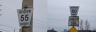
Key Facts
- Numbering Logic: Odd numbers are generally assigned to east-west routes, while even numbers are used for north-south routes.
- Regional Uniqueness: Greater Sudbury is the only census division in Northern Ontario with a numbered municipal road system.
- Historical Roots: Several current municipal roads were previously designated as provincial secondary highways.
- Administrative Shift: Roads transitioned from "regional" to "municipal" designations after the 2001 amalgamation.
Road Network Structure and Designations
The municipal road system serves as the backbone for transit between major communities such as Chelmsford, Azilda, Lively, and Hanmer. The network includes a variety of road types, from urban streets in the downtown core to rural connectors and specialized industrial access roads.
Urban and Arterial Routes
Many of the city's primary arteries are municipal roads. For example, Municipal Road 55 (formerly Highway 17) serves as a major corridor passing through Whitefish, Lively, and downtown Sudbury. Similarly, Municipal Road 71 (LaSalle Boulevard) and Municipal Road 73 (Maley Drive) provide critical high-capacity access in the New Sudbury area, with Maley Drive featuring sections of divided freeway and expressway.
Rural and Industrial Connectors
The system also supports the region's mining heritage. Municipal Road 4 travels through the ghost town of Victoria Mines, and Municipal Road 24 passes by the Creighton Mine ghost town. Other routes, such as Municipal Road 8, provide essential access to the communities of Onaping and Levack.
Detailed Route Directory
The following table provides a detailed overview of the numbered municipal roads within Greater Sudbury, including their termini and the communities they serve.
| Road Number | Primary Names | Western/Southern Terminus | Eastern/Northern Terminus | Major Communities |
|---|---|---|---|---|
| MR 3 | Bay Street | MR 4 | MR 55 | Whitefish |
| MR 4 | Fairbank Lake Road | Highway 17 | Wickie Rd / Park Rd | Worthington |
| MR 5 | Spanish River Road | Nairn and Hyman Boundary | MR 4 (Worthington) | Turbine |
| MR 8 | Nickel St / Third Ave / Mine Rd | Highway 144 | Mine Road | Onaping, Levack |
| MR 10 | Panache Lake Road | Panache North Shore Rd | MR 55 | Whitefish |
| MR 12 | Gordon Lake Road | MR 13 | Highway 144 | Larchwood |
| MR 13 | Vermilion Lake Rd / Joseph St | Mina Street | Highway 144 | Larchwood, Hull |
| MR 14 | Errington Ave / Main St | Highway 144 | MR 15 | Chelmsford |
| MR 15 | MR 15 / Main Street | Hwy 144 / MR 35 | MR 80 | Chelmsford, Boninville, Blezard Valley, Val Caron |
| MR 18 | Montée Rouleau / Gagnon St | MR 35 | MR 15 | Azilda |
| MR 21 | Notre-Dame Street | MR 35 | Azilda | Azilda |
| MR 24 | MR 24 / Main Street | MR 55 | Highway 144 | Lively |
| MR 30 | Power St / Godfrey Dr | MR 55 | MR 32 | Copper Cliff |
| MR 32 | Balsam Street | MR 55 | MR 30 | Copper Cliff |
| MR 34 | Big Nickel Mine Road | MR 55 | MR 35 | Gatchell / Little Britain |
| MR 35 | Elm Street | MR 55 | Hwy 144 / MR 15 | Chelmsford, Azilda, Downtown |
| MR 37 | Kelly Lake Road | Southview Drive | MR 55 | Robinson |
| MR 38 | Regent St / Beatty St | MR 55 / MR 46 | MR 42 / MR 58 | Little Britain |
| MR 39 | Ramsey Lake Road | MR 80 | Kirkwood Drive | Ramsey Lake shore |
| MR 40 | Martindale Road | MR 40/46/47 | MR 55 | Robinson |
| MR 42 | Frood Rd / Elm St | MR 71 | MR 67 | Downtown / Donovan |
| MR 43 | Ontario St / McLeod St / Hyland Dr | MR 40 | MR 46 | Gatchell |
| MR 45 | York Street | MR 46 | MR 80 | Downtown |
| MR 46 | Regent Street | Hwy 69 / Hwy 17 | MR 55 / MR 38 | Lo-Ellen / Four Corners |
| MR 47 | Walford Road | MR 40 / MR 46 | MR 80 | Lockerby |
| MR 49 | Lorne Street | MR 55 | MR 35 | Downtown |
| MR 51 | Larch Street | MR 67 | MR 49 | Downtown |
| MR 53 | Cedar Street | MR 67 | MR 49 | Downtown |
| MR 55 | Old Hwy 17 / Lorne St / Douglas St | Highway 17 (West) | Highway 17 (Coniston) | Whitefish, Lively, Downtown, Coniston |
| MR 57 | Van Horne Street | MR 80 | MR 67 | Downtown |
| MR 58 | Kathleen Street | MR 42 / MR 38 | MR 80 | Donovan / Flour Mill |
| MR 61 | Ste-Anne Road | Mackenzie St / MR 67 | MR 80 | Downtown |
| MR 63 | College Street | MR 35 / MR 55 | MR 58 | Downtown |
| MR 66 | Barry Downe Road | MR 55 | MR 73 | New Sudbury |
| MR 67 | Elgin St / Morris St / East St | MR 55 / MR 61 | Highway 17 | Downtown, Minnow Lake, Coniston |
| MR 68 | Auger Avenue | MR 86 | MR 71 | New Sudbury |
| MR 70 | Bancroft Drive | MR 67 | MR 55 | Minnow Lake |
| MR 71 | LaSalle Boulevard | MR 35 | MR 86 | New Sudbury |
| MR 72 | Second Avenue | MR 67 | MR 55 / MR 86 | Minnow Lake |
| MR 73 | Maley Drive | MR 71 | MR 86 | New Sudbury |
| MR 74 | Moonlight Beach Road | MR 67 | MR 55 | Adamsdale |
| MR 80 | Long Lake Rd / Paris St / Côté Blvd | Dew Drop Rd / Tilton Lake Rd | MR 85 | Four Corners, Downtown, Hanmer |
| MR 84 | Capreol Rd / Sellwood Ave / Milnet Rd | MR 80 | Sudbury District Border | Hanmer, Capreol, Sellwood |
| MR 85 | Radar Road | MR 86 | MR 80 | Hanmer |
| MR 86 | Falconbridge Hwy / Skead Rd | MR 55 / MR 72 | Skead | New Sudbury, Garson, Skead |
| MR 88 | Elmview Drive | MR 80 | Dominion Drive | Hanmer |
| MR 89 | Longyear Drive | MR 86 | Edison Road | Falconbridge |
| MR 90 | Garson-Coniston Road | Highway 17 | MR 86 | Garson, Coniston |
| MR 93 | Second Avenue | MR 67 | Highway 17 | Coniston |
| MR 96 | Desmarais Road | MR 80 | Nelson Lake Rd / Frenchman Lake Rd | Val Thérèse |
| MR 97 | Capreol Lake Road | MR 84 | Fire Roads (Capreol/Wahnapitae) | Capreol |
| MR 537 | Greater Sudbury Road 537 | Hwy 537 (Finni Rd) | Highway 17 | Wahnapitae |
Frequently Asked Questions
How are the municipal roads in Greater Sudbury numbered?
The city generally uses a grid-based numbering system where odd numbers are assigned to routes running east-west and even numbers are assigned to routes running north-south.
What is the difference between regional and municipal roads in Sudbury?
Prior to the 2001 amalgamation, the roads were managed by the Regional Municipality of Sudbury and called regional roads. After amalgamation, they became municipal roads under the city's jurisdiction.
Which municipal roads were formerly provincial highways?
Several roads were previously provincial highways, including MR 4 (Highway 658), MR 8 (Highway 544/544A), MR 10 (Highway 549), MR 15 (Highway 634), MR 24 (Highway 536), MR 55 (Highway 17), and MR 86 (Highway 541).
Are there any unique road features in the Greater Sudbury system?
Yes, the system includes a mix of urban streets, divided freeways (such as parts of MR 73), and roads that pass through ghost towns like Victoria Mines (MR 4) and Creighton Mine (MR 24).
Where is the Sudbury Airport located in relation to the municipal roads?
The Sudbury Airport is located on Municipal Road 86 (Falconbridge Highway/Skead Road).