Faubourg Lafayette: The History and Evolution of a New Orleans Neighborhood
Nestled within the Central City district of New Orleans, Faubourg Lafayette is a neighborhood defined by its deep historical roots and its role in the urban expansion of Louisiana. From its origins as a colonial-era suburban development to its current status as a vibrant residential and commercial hub, the area reflects the broader social and architectural shifts of the Crescent City.
To understand Faubourg Lafayette, one must first understand the concept of a faubourg—a French term for a suburb or a smaller settlement located just outside the boundaries of a larger city. As New Orleans grew beyond the original French Quarter, several faubourgs emerged to the west, paving the way for the city's modern layout.
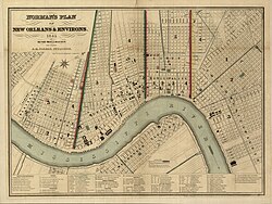
Key Facts
- Location: Central City district, 10th Ward of New Orleans.
- Historical Significance: Once part of the City of Lafayette, the first parish seat of Jefferson Parish.
- Main Thoroughfare: Oretha Castle Haley Boulevard.
- Land Area: Approximately 0.264 square miles (0.68 km²).
- Elevation: Ranges from 0 to 4 feet (0–1.2 m).
- Key Institutions: Home to the Southern Food and Beverage Museum (SoFAB) and the International High School of New Orleans.
The Historical City of Lafayette
The origins of Faubourg Lafayette date back to the early 19th century. Between 1813 and 1824, the Panis plantation—located between St. Andrew Street and Phillip Street—was transformed into a residential development. In 1824, John Poultney commissioned Joseph Pilie to subdivide the land into lots and squares, naming the area "Faubourg Lafayette" in honor of the Marquis de Lafayette, the French hero of the American Revolution who visited New Orleans in 1825.
Incorporation and Annexation
As the area grew, it merged with other nearby developments. On April 1, 1833, Faubourg Lafayette joined Faubourg Livaudais and Faubourg Nuns to incorporate as the City of Lafayette. This new entity served as the first parish seat for Jefferson Parish. By the 1840s, it further expanded by absorbing Faubourg Delassize.
At its peak as an independent city in 1850, Lafayette recorded a population of 14,190, making it the second-largest city in Louisiana at the time. However, this independence was short-lived; in 1852, the City of Lafayette was annexed into New Orleans, eventually becoming part of the city's 10th and 11th Wards.
Modern Geography and Demographics
The modern area recognized as Faubourg Lafayette differs from the boundaries of the original 19th-century city. Today, it is situated in Central City, bounded by St. Charles Avenue (from Jackson Avenue to the Pontchartrain Expressway) and Simon Bolivar Avenue.
| Census Year | Total Population | Median Household Income (2012 USD) | % Population 65+ | % Labor Force Participation |
|---|---|---|---|---|
| 1990 | 1,520 | $30,917 | 23.4% | 39.35% |
| 2000 | 1,490 | $28,551 | 22.35% | 49.35% |
| 2012 | 1,352 | $29,229 | 11.4% | 76.3% |
Social Evolution and Public Housing
Faubourg Lafayette holds a significant place in American social history as the site of the nation's first public housing experiment. In 1937, under President Roosevelt's New Deal and the Wagner-Steagall Act, the Magnolia Housing Projects were constructed.
Later, the area was home to the St. Thomas Development. This project reflected the city's struggle with segregation; it remained exclusively white until the 1960s. Following desegregation, the project faced severe challenges and eventually became one of the city's most dangerous areas. After Hurricane Katrina, the St. Thomas Development was demolished to make way for a mixed-income neighborhood intended to reduce crime, providing relocation assistance to over 3,000 families.
Landmarks and Community Life
The heart of the neighborhood is Oretha Castle Haley Boulevard, a bustling corridor of commerce and culture. Key landmarks include:
- Southern Food and Beverage Museum (SoFAB): Located in the former Dryades Market building, this museum celebrates culinary history, including the Museum of the American Cocktail and a Gallery of the States.
- New Orleans Jazz Market: A premier venue for jazz performances.
- Brown's Velvet Dairy: A local dairy factory and significant tourist attraction.
- Ashe Cultural Arts Center: A hub for visual arts, dance, and youth programs.
- Cafe Reconcile: A nonprofit café that provides culinary training for at-risk youth.
- New Orleans Mission Homeless Shelter: A critical resource providing food and shelter on Baronne Street.
Education and Specialized Learning
The neighborhood is home to several diverse educational institutions. The International High School of New Orleans is a highly regarded charter school with open enrollment. For students with major learning difficulties, the St. Michael Special School provides vocational and physical training. Additionally, the Tulane School of Public Health and Tropical Medicine offers world-class graduate and undergraduate programs with a high post-graduate employment rate.
Frequently Asked Questions
What does the word "faubourg" mean?
Faubourg is a French term meaning "suburb," referring to a smaller development or neighborhood located outside the main boundaries of a larger city.
Was Faubourg Lafayette ever its own city?
Yes. In 1833, it joined with Faubourg Livaudais and Faubourg Nuns to form the City of Lafayette, which served as the first parish seat of Jefferson Parish before being annexed by New Orleans in 1852.
What is the significance of the St. Thomas Development?
The St. Thomas Development was a major public housing project that illustrated the history of segregation and urban decay in New Orleans. It was demolished after Hurricane Katrina to create a mixed-income community.
What is the main street of the neighborhood?
Oretha Castle Haley Boulevard is the primary street, housing the majority of the neighborhood's businesses, museums, and cultural attractions.
Which museum is located in the former Dryades Market?
The Southern Food and Beverage Museum (SoFAB) is located in the building that formerly housed the Dryades Market.