Fairlington: A Journey Through Virginia's Historic Landscape
Fairlington stands today as a testament to community planning and architectural resilience. Located at the intersection of Arlington and Alexandria, this unique neighborhood has evolved from 17th-century indigenous lands and colonial plantations into one of the most significant examples of wartime housing in the United States. Its story is a reflection of the broader American experience, spanning the colonial era, the Civil War, and the urgent demands of the Second World War.
Early Colonial Roots and Land Grants
The history of the area begins in the 17th century, when it was situated near a Necostin Indian village. By the early 18th century, the land was integrated into the English headright system—a method of granting land to settlers. A 534-acre tract was granted to William Struttfield, one of the 48 original landowners in what would eventually become Arlington County.
By 1756, the land passed to John Carlyle, a close associate of George Washington and the builder of the historic Carlyle House in Alexandria. For 150 years, Carlyle and his heirs maintained ownership of the area. Around 1770, Carlyle established a plantation and summer house known as Torthorwald (later renamed Morven) near the intersection of 30th Street South and South Columbus Street. This estate served as a stud farm, complemented by a grist mill operated downstream. Notably, George Washington also owned a portion of the land near South 28th Street and Abingdon Elementary School.
The region's political status shifted frequently during the early republic. In 1790, the area became part of the original District of Columbia under congressional control. However, in 1846, the land was retroceded to Virginia, becoming part of Alexandria County, Virginia.
Military Occupation and Rural Transition
The American Civil War brought a sudden military presence to the landscape. Following Virginia's secession in April 1861, the United States military occupied Northern Virginia to protect the Army of the Potomac's base in Alexandria. To secure the Four Mile Run valley, two key fortifications were built:
- Fort Reynolds: A redoubt constructed in September 1861 with a 360-yard perimeter and 12 gun emplacements.
- Battery Garesche: Built late in 1861 to protect the higher ground above Fort Reynolds, featuring a 166-yard perimeter and 8 guns.
These defenses ensured the area remained under U.S. military control until 1870. Following the war, the land returned to a rural state, characterized by woods and small farms. In 1879, Hawkins Smith consolidated the land, renaming the Morven estate as Hampton. His son, Hawkins Smith II, developed it into a premier horse farm before selling it in 1926. During the early 20th century, the land was subdivided for sharecroppers, and a portion of South Fairlington even served as an airfield until the mid-1930s.
The Birth of a Wartime Community
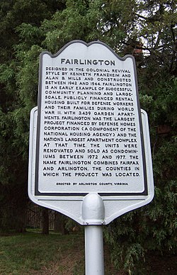
The modern identity of Fairlington was forged during World War II. In 1940, President Franklin D. Roosevelt created the Defense Homes Corporation (part of the Federal Housing Administration) to address the critical shortage of housing for military and civilian defense personnel. By February 1942, the corporation had acquired 322 acres to build a project originally called Seminary Heights.
Strategically located just 2.5 miles from the newly constructed Pentagon, the project was renamed Fairlington. Designed in the Colonial Revival style by architects Kenneth Franzheim and Alan B. Mills, the development grew rapidly. By the end of 1943, nearly 2,415 units were complete; by 1945, the project reached its full capacity of 3,439 units at a total cost of $35 million.
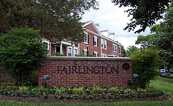
Following the war, the property was sold in 1947 to the Fairmac Realty Corporation and operated as rental apartments. The surrounding area urbanized quickly, with the opening of the Shirlington Shopping Center in 1945 and the Bradlee Shopping Center in the 1950s.
Evolution into Condominiums and Historic Recognition
In the late 1960s, the owners (Hartford Insurance) considered replacing the garden apartments with high-rise buildings. Instead, they opted for a pioneering conversion to condominiums in 1972. This was the largest project of its kind in Virginia at the time. Under the management of CBI-Fairmac, the apartments were modified over five years, replacing boiler houses with recreation facilities and dividing common basements.
The conversion created seven legal entities under the Virginia Horizontal Property Act. Units began selling in 1972 for between $19,000 and $45,500, with the final sales concluding in 1978. Other community changes followed, including the 1979 conversion of Fairlington Elementary School into the Fairlington Community Center and the 1967 construction of a bridge connecting North and South Fairlington.
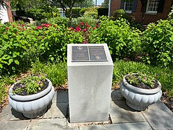
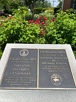
Fairlington's architectural and social significance was formally recognized in the late 1990s. It was listed on the Virginia Landmarks Register in December 1998 and the National Register of Historic Places in March 1999.
Key Facts
- Total Units: 3,439 garden apartments completed by 1945.
- Original Cost: $35 million (approximately $626 million in 2025 dollars).
- Architects: Kenneth Franzheim and Alan B. Mills.
- Naming: The name "Fairlington" is a portmanteau of Fairfax and Arlington counties.
- Historic Status: Listed on the National Register of Historic Places in March 1999.
- Military History: Site of Fort Reynolds and Battery Garesche during the Civil War.
| Period/Event | Key Detail | Significance |
|---|---|---|
| 18th Century | Carlyle Plantation | Established as a stud farm and grist mill site. |
| 1861-1870 | Union Occupation | Construction of Fort Reynolds and Battery Garesche. |
| 1942-1945 | Defense Homes Corp | Built 3,439 units for WWII defense workers. |
| 1972-1978 | Condo Conversion | Largest scale condominium project in Virginia to date. |
| 1999 | NRHP Listing | Recognized as a National Register of Historic Places site. |
Frequently Asked Questions
Where does the name Fairlington come from?
The name is a combination of Fairfax and Arlington, the two counties in which the original project was located.
Who designed the Fairlington community?
The community was designed in the Colonial Revival style by architects Kenneth Franzheim and Alan B. Mills.
What was the original purpose of Fairlington?
It was built by the Defense Homes Corporation to provide large-scale, publicly financed rental housing for civilian and military defense personnel during World War II.
What military sites were located in the Fairlington area?
During the Civil War, the area hosted Fort Reynolds and Battery Garesche, which were used by the Union Army to defend the approach to Alexandria.
When did Fairlington become condominiums?
The conversion from rental apartments to condominiums began in 1972 and was completed by 1978.