Comodoro Rivadavia: The Energy Capital of Argentine Patagonia
Perched on the shores of the San Jorge Gulf in the province of Chubut, Comodoro Rivadavia is a city defined by its resilience and energy. As the largest city in Chubut and the most significant urban center south of the 45th parallel, it serves as a vital commercial and transportation hub for southern Argentina. Known widely as the Capital Nacional del Petróleo (National Oil Capital), the city's identity is inextricably linked to the depths of the earth and the strength of the Patagonian winds.
From its humble beginnings as a strategic port to its evolution into an industrial powerhouse, Comodoro Rivadavia blends a rugged geographic landscape with a sophisticated economic infrastructure. Whether through its historic oil wells or its cutting-edge wind farms, the city continues to power the nation.

Key Facts
- Founded: February 23, 1901.
- Nickname: National Oil Capital (Capital Nacional del Petróleo).
- Population: 201,854 (2022 census).
- Geography: Located on the San Jorge Gulf at the foot of Chenque Hill.
- Economic Pillars: Petroleum extraction, wind energy, and maritime logistics.
- Climate: Cold semi-desert (BSk) with significant wind patterns.
The Foundation and Early History
The necessity for a deep-water port to support the inland settlement of Sarmiento led to the birth of Comodoro Rivadavia. In 1889, Francisco Pietrobelli sought an anchoring place for deep-draft ships, eventually leading to the establishment of a port area. The city was officially founded by decree on February 23, 1901, and named in honor of Martín Rivadavia, the shipping minister and a key proponent of developing southern Argentina.
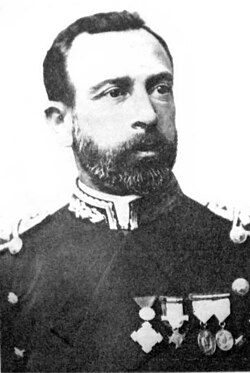
The early community was a melting pot of cultures, including Welsh settlers and Boer families escaping British rule in South Africa. These Afrikaner settlers arrived in 1903, attempting to establish farms in the arid landscape. However, the lack of water became a critical obstacle, leading to a discovery that would change the region's destiny forever.
The Discovery of Oil and Industrial Growth
In 1907, while drilling for water to support the Boer farmers, a crew struck oil at a depth of 539 meters. This accidental discovery sparked an economic boom. Under Argentine law, mineral deposits belong to the state, meaning the settlers did not profit directly, but the city grew rapidly around the new industry.
The establishment of YPF (Yacimientos Petrolíferos Fiscales) in 1922—the first state-owned oil company in the world—accelerated urban development. Under the leadership of Engineer Enrique Mosconi, YPF improved housing, healthcare, and employment. By the 1960s, under President Arturo Frondizi, the installation of foreign companies further expanded the sector. Today, the San Jorge Gulf remains a leader in extraction, producing approximately 46% of Argentina's total crude oil.
Geography and Urban Layout
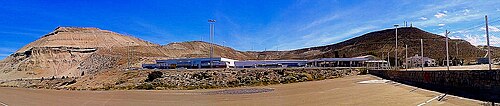
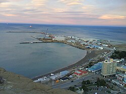
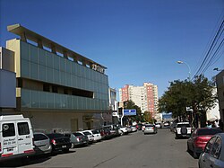
The city is characterized by its dramatic coastal geography, most notably the Chenque Hills and the Viteaux area. The urban sprawl evolved from original oil camps into distinct neighborhoods. The South Area is the most densely populated, while the Northern Area is organized by "kilometers," hosting key institutions like the National University of Patagonia San Juan Bosco.
A notable suburb is Rada Tilly, located 12 km south. Founded in 1948, it has transitioned from a beach village into a major tourism hub and residential suburb.
Modern Infrastructure and Diversification
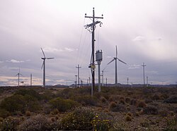
While oil remains central, Comodoro Rivadavia is diversifying its energy portfolio. The city now hosts one of Latin America's most significant wind farms on Cerro Chenque, utilizing the region's powerful winds to provide 20% of the city's energy needs.
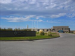
The port facilities are equally diverse, featuring the principal port for commodities and naval repairs, the Repsol-YPF pier for fuel unloading, and specialized facilities at Caleta Olivares and Caleta Cordova for crude oil loading. Additionally, the city supports heavy industry, including a concrete production plant operated by Petroquimica Comodoro Rivadavia S.A.
Culture and Education
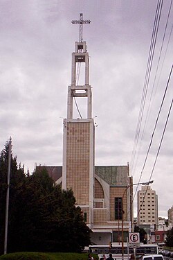
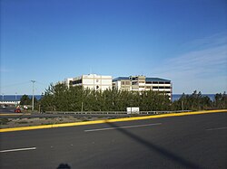
The city is a regional center for faith and learning. The San Juan Bosco Cathedral is unique as the only cathedral in the world dedicated to the founder of the Salesian Order. Educationally, the city is anchored by the main faculty of the National University of Patagonia San Juan Bosco, fostering academic growth in the region.
Climate Overview
Comodoro Rivadavia possesses a cold semi-desert climate (BSk). It is one of the southernmost locations globally to maintain a subtropical profile, where all twelve monthly mean temperatures remain above 6°C. The region is characterized by low annual rainfall (approximately 250 mm) and high wind speeds, which can reach 100 km/h during winter.
| Attribute | Detail |
|---|---|
| Coordinates | 45°51′53″S 67°28′51″W |
| Elevation | 61 m (200 ft) |
| Total Area | 548.2 km² |
| Population (2022) | 201,854 |
| Average Jan Temp | 19.7 °C (67.5 °F) |
| Average July Temp | 6.8 °C (44.2 °F) |
| Annual Precipitation | 258.1 mm |
Frequently Asked Questions
Why is Comodoro Rivadavia called the National Oil Capital?
The city earned this title because the Argentine oil industry began here following the accidental discovery of oil in 1907. It remains one of the country's most productive petroleum districts.
What is the significance of the San Juan Bosco Cathedral?
It is the only cathedral in the world dedicated to San Juan Bosco, the founder of the Salesian Order, and serves as the seat of the Diocese of Comodoro Rivadavia.
How does the city utilize wind energy?
The city leverages its high wind speeds via a massive wind farm on Cerro Chenque and surrounding hills, which is one of the largest in Latin America and provides 20% of the city's electricity.
Who were the early settlers of the region?
Early settlers included Welsh immigrants and Boer families from South Africa, who arrived in the early 1900s to establish farming communities.
What is the relationship between Comodoro Rivadavia and Rada Tilly?
Rada Tilly is a beach resort and suburb located 12 km south of the main city, serving as an important hub for tourism in the Chubut province.