Civil Engineering and Roadway Terminology
Modern transportation relies on a complex network of infrastructure designed for safety, efficiency, and flow. From the subtle slope of the pavement to the massive scale of multi-level interchanges, every element of a road is engineered with a specific purpose. Understanding these technical terms provides insight into how traffic is managed and how road safety is maintained.
Foundational Roadway Components
At its most basic level, a carriageway (or roadway) is a width of road where vehicles can move laterally without being restricted by physical barriers. A single roadway may consist of one or more carriageways. In some designs, a single carriageway handles traffic in both directions, while multiple carriageways are used to separate traffic by direction or vehicle type.
The physical edge of the roadway is often defined by a curb (or kerb), which is the raised pavement situated along the edge. The surface itself is rarely perfectly flat; engineers implement cant or camber, which is the gradient of the road surface at 90° to the direction of travel. This difference in height between the edge and the crown of the road is essential for water drainage and vehicle stability.
Specialized Road Types and Classifications
Roads are categorized based on their function and jurisdiction. A controlled-access highway (also known as a motorway or freeway) is designed for high-speed traffic with strictly regulated entry and exit points. In contrast, a collector road (or distributor road) is a low-to-moderate-capacity road that moves traffic from local streets to larger arterial roads.
In North America, specifically the United States and Ontario, Canada, a county highway is a road designated and maintained by the county highway department. Some regions have unique legal designations, such as the constitutional route, a highway defined within the state constitution, a feature found exclusively in Minnesota.
Advanced Traffic Engineering and Intersections
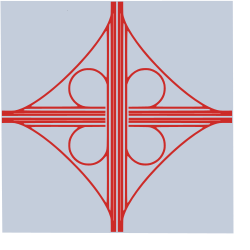
To manage the flow of vehicles and reduce collisions, engineers use various intersection designs. A cloverleaf interchange is a two-level junction featuring eight ramps. Four of these are loops that create a cloverleaf shape when viewed from above. This design ensures traffic is fully grade-separated, meaning vehicles do not need to stop to transition between the two roadways.
For urban environments, a continuous-flow intersection (CFI)—also known as a crossover displaced left-turn (XDL) or DLT—optimizes movement. In these intersections, vehicles intending to turn across opposing traffic cross over before entering the main intersection, eliminating the need for a dedicated left-turn signal within the intersection itself.
Traffic Management and Safety Tools
Safety is maintained through a variety of markers and lanes. Cat's eyes are retroreflective safety devices used as raised pavement markers to guide drivers. For steep inclines, a climbing lane is provided to allow slower, large vehicles like semi-trailer trucks to ascend without impeding faster traffic.
Traffic flow can also be dynamically managed. Contraflow lane reversal involves changing the direction of traffic in a specific lane to assist with roadworks, special events, or emergency evacuations. In areas of high demand, congestion pricing may be implemented, which is a system of surcharging users to reduce traffic volume.
Key Facts
- Cloverleaf Interchanges: Use eight ramps to provide full grade separation, allowing traffic to change roads without stopping.
- Camber/Cant: The 90° gradient from the road's crown to its edge, critical for drainage.
- Constitutional Routes: A rare highway designation found only in Minnesota.
- CFI Intersections: Displace left turns to remove the need for internal intersection signals.
- Carriageways: The unobstructed width of a road; can be single or multiple per roadway.
Roadway Terminology Summary
| Term | Definition | Primary Purpose |
|---|---|---|
| Camber | Road surface gradient at 90° to travel | Drainage and stability |
| Collector Road | Low-to-moderate capacity road | Connecting local streets to arterials |
| Cloverleaf | Two-level interchange with loop ramps | Non-stop grade-separated transitions |
| Concurrency | One road bearing multiple route numbers | Route identification |
| Cul-de-sac | Street with only one inlet/outlet | Limited access/Dead end |
Frequently Asked Questions
What is the difference between a carriageway and a roadway?
A roadway is the overall width of the road, which can be composed of one or more carriageways. A carriageway is specifically the portion of the road where vehicles are not restricted by physical barriers when moving laterally.
How does a continuous-flow intersection (CFI) work?
A CFI allows vehicles making a turn across opposing traffic to cross over to the other side of the road before they reach the main intersection. This removes the need for a left-turn signal at the center of the intersection.
What is a climbing lane used for?
A climbing lane is a specialized lane designed for steep grades, allowing slower-moving large vehicles, such as semi-trailer trucks, to ascend without blocking faster traffic in the primary lanes.
What is the purpose of a crossbuck?
A crossbuck is a specific type of traffic sign used to alert drivers that they are approaching a level railway crossing.
What is concurrency in road numbering?
Concurrency occurs when a single physical stretch of road is assigned two or more different highway, motorway, or route numbers simultaneously.