Charnwood Forest: A Journey Through Ancient Geology and Heritage
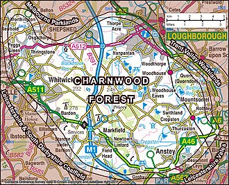
Located in northwestern Leicestershire, England, Charnwood Forest is a striking landscape of undulating hills, rocky outcrops, and picturesque moorlands. Bounded by the towns of Leicester, Loughborough, and Coalville, this region is far more than a scenic getaway; it is a geological treasure trove containing some of the oldest rocks in England.
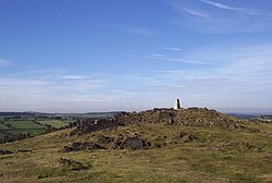
The terrain is characterized by its elevation, generally sitting at 600 feet (180 m) and above, with approximately 6,100 acres exceeding this height. The crown of the region is Bardon Hill, which reaches a peak of 912 feet (278 m).
Key Facts
- Highest Point: Bardon Hill at 912 feet (278 m).
- Geological Age: Contains Precambrian rocks dating back over 600 million years.
- Paleontological Fame: Site of the discovery of Charnia masoni, the earliest known large, complex fossilized species.
- Conservation Status: Home to a National Nature Reserve (NNR), 19 Sites of Special Scientific Interest (SSSIs), and is part of the English National Forest.
- Historical Significance: Evidence of habitation dating back to the Neolithic period (4,000–2,000 BC).
Ancient Geology and the Dawn of Life
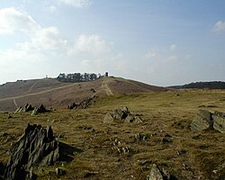
The craggy landscape of Charnwood Forest is primarily of volcanic origin. These Precambrian rocks—those formed before the Cambrian period—date back more than 600 million years, making them some of the most ancient geological formations in the British Isles.
The area gained international scientific fame through the discovery of Charnia masoni. Found in a quarry near Woodhouse Eaves in 1956 and 1957 by schoolchildren Tina Negus and Roger Mason, this fossil represents the earliest recorded large, complex species. While Roger Mason received the naming credit, the discovery paved the way for the identification of Precambrian fossils worldwide.
Human History and Archaeology
Human presence in Charnwood Forest stretches back to the Neolithic period (approximately 4,000–2,000 BC). Archaeologists have identified a specific group of stone axes, known as 'Group XX', which were crafted from the 'Bradgate Formation' rock native to this area. A 2026 petrology study suggests Windmill Hill as a likely source outcrop for these tools.
Moving into the Iron Age (600 BC to 43 AD), the region was occupied by the Coritani tribe. One of the most prominent remnants of this era is the hill fort at Beacon Hill, which remains a visible landmark today.
Following the Norman conquest, the landscape shifted as new settlements emerged. Between 1086 and 1153, the village of Quorn was established, and by 1228, significant portions of the forest up to Woodhouse had been cleared for agriculture.
Industry, Literature, and the Modern Landscape
The region's hard stone has been a vital economic resource for centuries. Historically used for quern-stones (hand-operated grinding stones) and whetstones, the granite from Bardon Hill, Buddon Hill, and Whitwick continues to supply crushed aggregate across southern Britain.
The western flank of the forest tells a story of industrial transition. Once an active coalfield, the area around Coalville is currently being regenerated and replanted as part of the National Forest initiative. The M1 motorway also traverses the forest between junctions 22 and 23.
Beyond science and industry, the forest has inspired the arts. It served as the basis for the "Charnwood Poems" by Albert Francis Cross and provides the mystical setting for Graham Joyce's 2012 novel, Some Kind of Fairy Tale, where the forest acts as a portal to a fairy realm.
The Charnwood Forest Geopark
To preserve this unique heritage, the Charnwood Forest Geopark partnership was formed. This collaboration of 17 statutory, NGO, and charitable partners—led by The National Forest—aims to establish the area as a UNESCO Global Geopark. Since its origins in 2007 and formal establishment in 2013, the partnership has focused on geological conservation, habitat restoration, and cultural events. The bid for full accreditation was submitted in Autumn 2025, with a final decision expected by 2027.
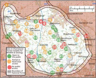
Wildlife and Geological Sites
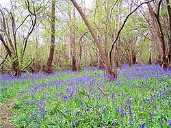
Spanning approximately 67 square miles across the Charnwood, North West Leicestershire, and Hinckley and Bosworth districts, the forest is a sanctuary for biodiversity. It features a complex network of protected sites, including 13 Regionally Important Geological Sites (RIGS) and various nature reserves.
Visitors can explore the landscape via the Leicestershire Round and the Ivanhoe Way, two long-distance walking routes. While some sites are restricted to protect fragile ecosystems, seventeen are fully open to the public.
| Site Name | Status | Access | Primary Habitat/Feature |
|---|---|---|---|
| Bradgate Park | SSSI, GCR(I) | Open | Bracken heath, ancient oaks, and rocks |
| Bardon Hill | SSSI(B) | Partial | High moorland (Highest point in Leicestershire) |
| Beacon Hill | SSSI, GCR, Ancient Monument | Open | Heathland and Iron Age hillfort |
| Swithland Wood | SSSI(B&G) | Open | Ancient woodland and slate quarries |
| Charnwood Lodge | NNR, SSSI, GCR | Restricted | Acid and heath grasslands |
| Cliffe Hill Quarry | SSSI(G), GCR(I), RIGS | None | Precambrian Rocks |
Frequently Asked Questions
What is the significance of Charnia masoni?
Charnia masoni is the earliest-known large, complex fossilized species on record. Its discovery in Charnwood Forest in the 1950s proved that complex life existed during the Precambrian era, long before the Cambrian explosion.
What is the highest point in Charnwood Forest?
The highest point is Bardon Hill, which reaches an elevation of 912 feet (278 m), making it the highest point in Leicestershire.
Can the public visit Charnwood Forest?
Yes, many areas are accessible. Seventeen specific sites are open to the public, and the region is crisscrossed by footpaths, bridleways, and long-distance walking routes like the Ivanhoe Way.
What is the Charnwood Forest Geopark?
It is a partnership of 17 organizations working to protect the region's landscape and heritage while seeking official accreditation as a UNESCO Global Geopark.
What are the 'Group XX' stone axes?
These are Neolithic stone tools found across the UK. They are identified as having been made from the 'Bradgate Formation' rock, confirming they originated in the Charnwood Forest area.