Canton of Aargau
The Canton of Aargau is a central pillar of the Swiss Confederation, blending a rich medieval heritage with modern industrial prowess. Located on the Swiss Plateau, it serves as a bridge between the Alps and the Jura mountains, characterized by its rolling hills, fertile farmland, and a history of strategic political shifts.
From its origins as a Habsburg stronghold to its formal establishment in 1803, Aargau has evolved into a diverse region of 196 municipalities and 11 districts, with its capital and largest city, Aarau, serving as its administrative heart.
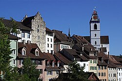
Key Facts
- Capital: Aarau
- Joined Confederation: 1803
- Population: 694,072 (as of December 2020)
- Total Area: 1,403.76 km²
- GDP per capita: CHF 63,177 (2020)
- Official Language: German
- Highest Point: Geissfluegrat (908 m)
Historical Evolution
Medieval Roots and the Habsburgs
In the late 13th century, the region was divided among the imperial cities of Bern, Lucerne, and Solothurn, and the canton of Unterwalden. The core of what is now Aargau remained under the control of the Habsburgs until 1415, when the Old Swiss Confederacy conquered the territory. The capture of Habsburg Castle by Bern in April 1415 marked a pivotal shift in regional power.
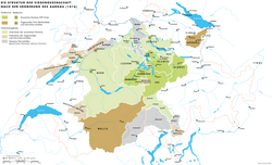
Regional Administration: Unteraargau and Freie Ämter
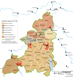
Following the conquest, the region was split into different administrative zones. Unteraargau (or Berner Aargau) was managed by Bern, primarily as a source of grain. By the late 18th century, Bern encouraged industrialization here, leading to significant population growth.
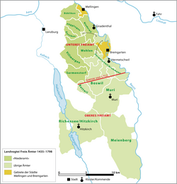
The Freie Ämter were collectively administered as subject territories by the Confederation. This area became a flashpoint for religious conflict during the First War of Villmergen (1656) and the Toggenburg War (1712). The 1712 Peace of Aarau reorganized the region, dividing the Freie Ämter into Upper and Lower sections based on the prevailing political and religious influence of the time.
The County of Baden and the Act of Mediation
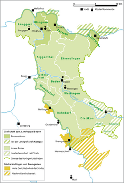
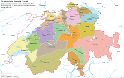
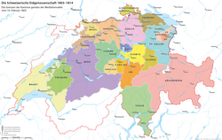
The County of Baden existed as a separate entity until the French invasion of 1798, which led to the creation of the short-lived canton of Baden under the Helvetic Republic (a French-imposed centralized state). The modern canton of Aargau was finally formed in 1803 through the Act of Mediation, merging the former cantons of Aargau, Baden, and Fricktal.
Jewish History in Aargau
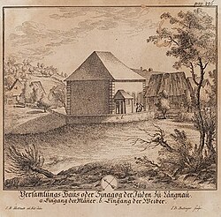
Aargau holds a unique place in Swiss history as the only federal condominium where Jews were tolerated during the 17th century. By 1774, the Jewish population was restricted to the towns of Endingen and Lengnau. Despite pressure from the rural upper class for their expulsion, authorities maintained the community due to the financial benefits of taxes on cattle trading and peddling.
Geography and Land Use
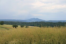
Aargau is one of Switzerland's least mountainous cantons. It is situated on the Swiss Plateau, north of the Alps and east of the Jura. The landscape is a mix of forests (approximately one-third of the land) and agricultural fields (nearly half of the land). Water bodies, including Lake Hallwil, account for about 2.4% of the territory.
Administrative Subdivisions
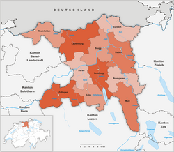
The canton is organized into 11 districts, including Baden, Brugg, and Zofingen. While there are 196 municipalities, there has been a gradual trend toward municipal mergers since the early 2000s to streamline administration.
Demographics and Society
As of 2020, the population stands at 694,072. The region is linguistically dominated by German, though Italian and Serbo-Croatian are the next most common languages. Religiously, the population is split primarily between Roman Catholicism (40.1%) and the Swiss Reformed Church (34.6%), with a growing percentage of the population identifying as non-religious.
Economy and Education
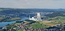
Aargau possesses a robust economy with a strong secondary sector. The tertiary (service) sector is the largest employer, with over 177,000 people employed in 21,530 businesses. The region is also home to critical infrastructure, such as the Leibstadt Nuclear Power Plant.
| Category | Detail |
|---|---|
| Total Population (2020) | 694,072 |
| Land Area | 1,403.76 km² |
| GDP (2020) | CHF 43.590 billion |
| Primary Language | German |
| Administrative Center | Aarau |
Frequently Asked Questions
When was the modern canton of Aargau formed?
The contemporary canton was formed in 1803 as a result of the Act of Mediation, combining the territories of the former cantons of Aargau, Baden, and Fricktal.
What is the significance of the Act of Mediation?
The Act of Mediation was a Napoleonic-era decree that dissolved the Helvetic Republic and reconstituted the Swiss Confederation, leading to the creation of Aargau as a full member canton.
Which is the most populous district in Aargau?
The District of Baden has seen striking growth since World War II and became the largest and densest population center in the canton.
What is the religious composition of the canton?
Based on 2000 census data, the population is predominantly Roman Catholic (40.1%) and Swiss Reformed (34.6%), with smaller communities of Muslims, Orthodox Christians, and others.
How is the land in Aargau primarily used?
Nearly half of the land is used for farming, while slightly over one-third is wooded. About 15% of the land is developed for housing and transportation.