Blautopf: The Mystical Blue Spring of the Swabian Jura
Located in Blaubeuren, within the Alb-Donau-Kreis of Baden-Württemberg, Germany, the Blautopf (literally "Blue Pot") is one of the most visually stunning natural landmarks in the Swabian Jura. Situated approximately 16 km west of Ulm, this striking spring serves as the source of the river Blau, which eventually flows into the Danube after a 14.5 km journey.
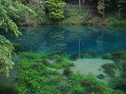
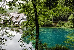
The spring is renowned for its deep, vibrant blue color and its role as the drain for an extensive subterranean cave system. Its unique appearance and mysterious depths have made it a subject of both scientific study and local folklore for centuries.
Key Facts
- Location: Blaubeuren, Baden-Württemberg, Germany.
- Status: The second largest spring in Germany.
- Depth: The spring forms a funnel-like shape reaching 21 meters (69 ft).
- Color Cause: Rayleigh scattering caused by nanoscale limestone particles.
- Hydrology: Source of the river Blau, which feeds into the Danube.
The Science Behind the Blue
The most striking feature of the Blautopf is its intense blue hue, which varies in intensity based on the weather and water flow. This phenomenon is caused by Rayleigh scattering—the same physical property that makes the sky appear blue. In the case of the Blautopf, nanoscale limestone particles are densely distributed in the water, preferentially scattering the blue wavelengths of visible light.
This is a similar optical effect to that found at the Blue Lagoon near Reykjavík, although the latter is caused by nanoscale silica particles rather than limestone.
Geology and the Karst Landscape
The Blautopf is situated in a karst environment, a geological landscape formed from the dissolution of soluble rocks like limestone. In such environments, water drains rapidly through the rock in one area and surfaces in another, meaning there are typically no permanent bodies of water on the surface except for springs like the Blautopf.
Because the system relies on subterranean drainage, the volume of the spring is heavily influenced by rainfall, although it never dries out completely. Over millennia, this process has carved out a massive network of caves. Two notable examples include:
- Blauhöhle (Blau-cave): Discovered in 1985 by Jochen Hasenmayer, this water-filled cave extends for approximately 1,500 meters.
- Apokalypse (Apocalypse): Discovered in 2006 by Jochen Malmann and Andreas Kücha, this is a dry cave measuring 170 meters long, 50 meters wide, and 50 meters high.
Diving and Exploration
Exploring the depths of the Blautopf is a perilous undertaking. The entrance to the Blauhöhle is located at a depth of about 22 meters (70 ft), requiring highly trained divers. Due to several accidents, including fatalities—the most recent in 2003—diving is strictly prohibited for the general public. Access is granted only to rescue services and scientific speleologists, such as the Arbeitsgemeinschaft Blautopf.
Modern research has utilized dye tracing to map the hydraulic connections of the area. This revealed that two independent underground rivers, the Ur-Blau and the Nordblau, flow through the Blauhöhlensystem and the Hessenhau Cave respectively, each contributing roughly half of the water that surfaces at the Blautopf.
Folklore and Cultural Legacy
The mystery of the spring's color and depth inspired numerous local legends. Some believed that vats of ink were poured into the water daily to maintain its color. Another tale claimed a water nix (a mythical water spirit) would steal any lead sounding line used to measure the depth, leading to the naming of a nearby rock called Klötzle Blei ("little block of lead").
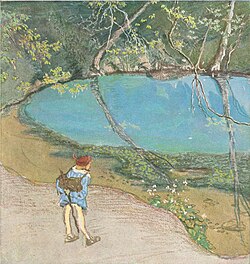
These myths were immortalized by the poet and novelist Eduard Mörike in his novella Das Stuttgarter Hutzelmännlein. The story features the Schöne Lau, a mermaid confined to the Blautopf by her husband, a water-nix from the Black Sea, who could only be freed after laughing five times.
Summary of Blautopf Characteristics
| Feature | Detail |
|---|---|
| Water Color | Blue (via Rayleigh scattering) |
| Spring Depth | 21 meters (69 ft) |
| Primary Cave | Blauhöhle (~1,500m water-filled) |
| Secondary Cave | Apokalypse (Dry, 170m long) |
| River Connection | Source of the Blau $\rightarrow$ Danube |
Frequently Asked Questions
Why is the water in the Blautopf blue?
The blue color is caused by nanoscale limestone particles in the water that trigger Rayleigh scattering, which preferentially scatters the blue light of the visible spectrum.
Can tourists dive into the Blautopf?
No. Due to the danger and a history of fatal accidents, diving is prohibited for the general public and is restricted to authorized scientific organizations and rescue services.
What is a karst environment?
A karst environment is a landscape formed from the dissolution of soluble rocks, such as limestone, characterized by subterranean drainage and the formation of caves and springs.
How does the Blautopf relate to the Danube river?
The Blautopf is the source of the river Blau. After flowing for 14.5 km, the river Blau empties into the Danube in the city of Ulm.
What is the significance of the "Apokalypse" cave?
The Apokalypse is a significant dry cave discovered in 2006, notable for its large dimensions (170m long, 50m wide, and 50m high) within the region's cave system.