Algiers Point: A Historic Landmark of the Lower Mississippi River
Located on the banks of the Lower Mississippi River in New Orleans, Louisiana, Algiers Point is more than just a residential neighborhood; it is a critical navigational landmark and a recognized historic district. Known for its unique geography and deep cultural roots, the area is home to residents known as Algierines (or Algerines) and serves as a vital point of reference for river pilotage—the art and science of navigating vessels through the river's complex channels.
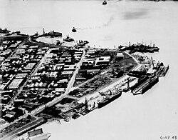
The Navigational Significance of Algiers Point
The Mississippi River follows a crescent-shaped path through New Orleans. As the river flows north and reaches the end of this crescent, it makes a sharp right-hand turn toward the east. While the French Quarter, Faubourg Marigny, and Bywater sit on the outside of this bend (the left descending bank), Algiers Point occupies the inner bend on the right descending bank.
This specific geography creates a unique hydrological environment. Just off the point, the river reaches its maximum depth, approximately 60 meters (200 ft), though this fluctuates annually as the river scours the bottom or deposits silt. To assist mariners, the U.S. Coast Guard maintains the Algiers Point Light "95" at coordinates 29°57′19″N 90°03′19″W. The U.S. Army Corps of Engineers identifies this location as mile 94.6 AHP (above Head of Passes).
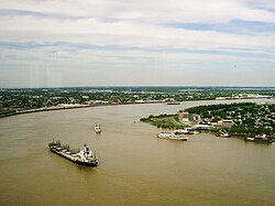
To manage the hazards of two-way traffic during periods of high water, the Coast Guard regulates marine traffic rounding the point. Licensed pilots operate from a tower atop the Gov. Nicholls Street Wharf, using marine VHF radio and a red-and-green traffic light system to coordinate vessel movements.
The Algiers Point Neighborhood
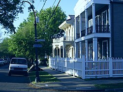
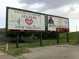
As a residential community, Algiers Point is a mixed-use neighborhood featuring a blend of professional services, coffee shops, restaurants, and bars. Its boundaries have shifted over time due to legal definitions and historical events. A conservative description defines the area as approximately 50 city blocks bounded by Opelousas Avenue, Atlantic Avenue, and the river.
Historically, the neighborhood extended to Newton Street. However, a devastating fire in 1895 destroyed many structures, leading to the reconstruction and renaming of several streets. Market Street was renamed Opelousas Avenue, which subsequently became the border separating Algiers Point from the McDonoghville section of Orleans Parish. Despite this, the Algiers Point National Historic District still recognizes the original southern boundary at Slidell Avenue, while the city-regulated historic district sets the boundary at Newton Street.
Community and Culture
Demographics and Education
The neighborhood has maintained a stable population over the last two decades. According to the 2000 census, there were 2,381 residents across 1,145 households. By the 2010 census, the population grew slightly to 2,455 people and 1,229 households.
Public education is managed by the Orleans Parish School Board (OPSB) or New Orleans Public Schools (NOPS). A notable institution in the area is the Adolph Meyer School (also known as the Harriet R. Tubman Elementary School), which is listed on the National Register of Historic Places.
The Cita Dennis Hubbell Library
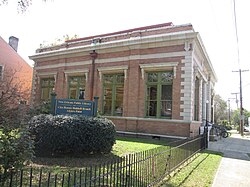
The neighborhood is home to the Cita Dennis Hubbell Library, the oldest public library building in New Orleans. Opened in 1907 as a Carnegie library (a library funded by philanthropist Andrew Carnegie), it was one of five such libraries in the city. As of 2013, it remains one of only two Carnegie libraries in New Orleans still operating as a library.
The library's history is one of resilience. After the opening of the Algiers Regional Library, the branch was closed, but a campaign led by Cita Dennis Hubbell successfully reopened it. Following the devastation of Hurricane Katrina in 2005, the library faced further closures due to structural integrity concerns and termite damage. After extensive renovations, it celebrated a grand re-opening in 2013.
Key Facts
- NRHP Status: Listed on the U.S. National Register of Historic Places on August 1, 1978 (Reference No. 78001428).
- River Depth: One of the deepest points of the Mississippi River, reaching approximately 60 meters (200 ft).
- Navigational Aid: Marked by the U.S. Coast Guard's Algiers Point Light "95".
- Historic Library: The Cita Dennis Hubbell Library is the city's oldest public library building.
- Geography: Located on the right descending bank of the river's crescent bend in New Orleans.
| Category | Detail |
|---|---|
| Coordinates | 29°57′19″N 90°3′19″W |
| NRHP Addition Date | August 1, 1978 |
| River Mile | 94.6 AHP (Above Head of Passes) |
| Population (2010) | 2,455 |
| Key Landmark | Cita Dennis Hubbell Library |
Frequently Asked Questions
What is the significance of Algiers Point for river navigation?
Algiers Point marks a sharp right-hand turn in the Mississippi River's crescent path. Because it is one of the deepest parts of the river and a critical turning point, the U.S. Coast Guard and licensed pilots regulate traffic here to ensure safety, especially during high water levels.
What are the boundaries of the Algiers Point neighborhood?
While boundaries vary by context, it is generally described as the area bounded by Opelousas Avenue, Atlantic Avenue, and the river. The National Historic District uses Slidell Avenue as the southern boundary, while the city-regulated district uses Newton Street.
What is the history of the Cita Dennis Hubbell Library?
Opened in 1907 as a Carnegie library, it is the oldest public library building in New Orleans. It has survived closures and structural damage, including termite issues and the impact of Hurricane Katrina, before reopening in 2013.
Who are the residents of Algiers Point called?
People from Algiers Point and the broader Algiers area are known as Algierines or Algerines.
What happened to the neighborhood after the 1895 fire?
The 1895 fire destroyed many old structures, leading to the reconstruction of several streets. Notably, Market Street was renamed Opelousas Avenue, which eventually became a boundary marker for the neighborhood.