The 2026 Kumamoto Earthquake: Analysis of Impact and Response
On July 28, 2026, at 16:27:15 JST, a powerful earthquake struck Kumamoto Prefecture in southern Japan. Officially named the 2026 Kumamoto earthquake (Reiwa 8-nen Kumamoto jishin), the event caused significant casualties, widespread infrastructure failure, and severe industrial disruptions. With a shallow depth of 10 km (6.2 mi), the quake delivered intense shaking that was felt far beyond the epicenter, reaching as far as South Korea and China.
Tectonic Setting and Seismic Mechanics
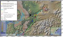
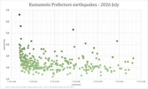
The earthquake originated 5 km (3.1 mi) east of the city of Uto. While the United States Geological Survey (USGS) recorded the magnitude at 6.8, the Japan Meteorological Agency (JMA) measured it at 7.1. The event occurred along the Hinagu Fault, characterized as a strike-slip fault—a type of fault where two blocks of earth slide past each other horizontally.
According to USGS modeling, the rupture occurred across a northeast-trending fault approximately 45 km (28 mi) long, extending to a depth of 20 km (12 mi). The rupture propagated bilaterally from the epicenter over roughly 18 seconds. The most intense slip occurred in a 20 by 15 km area southwest of the epicenter beneath Uki, where a maximum slip of 2.40 m (7 ft 10 in) was inferred at a depth of 5 km.
Seismic Intensity and Regional Reach
The earthquake produced extreme ground shaking. In Uki and Hikawa, the JMA recorded a maximum intensity of 7, the highest possible level on the Japan Meteorological Agency seismic intensity scale, which measures the observed shaking at a specific location. Other areas, including Mashiki, Uto, and Yatsushiro, experienced intensity 6+. The peak ground acceleration—the maximum acceleration of the ground during the shaking—reached 1.7 g, with a specific recording of 2,437 gals in Toyono, Uki, surpassing levels seen during the 2016 Kumamoto sequence.
The tremors were felt internationally. In South Korea, over 789 reports were filed, with the Korea Meteorological Administration reporting a Modified Mercalli intensity of III (Weak) in cities like Busan and Jeju. Residents in Shanghai, Ningbo, and Suzhou, China, also reported feeling the tremors.
Long Period Ground Motion
The JMA also noted significant Long Period Ground Motion (LPGM)—low-frequency shaking that can cause tall buildings to sway significantly. The Kumamoto Region registered the highest possible LPGM intensity of 4, while other areas in Oita, Miyazaki, and Kagoshima registered intensities between II and III.
Ground Deformation and Aftershocks
The physical landscape of Kumamoto was visibly altered. The Geospatial Information Authority of Japan reported significant crustal deformation, with the Sencho reference point in Yatsushiro shifting 0.84 m (2 ft 9 in) northeast. Satellite imagery revealed 10 km of visible surface rupturing between Hikawa and Yatsushiro, though geologists infer the total rupture length was closer to 30 km.
These ruptures caused severe damage to infrastructure. In Uki, vertical ground displacement occurred in an urban area, and a surface rupture beneath a viaduct near the Kyushu and South Kyushu expressways caused a support column to drop vertically.
The mainshock was followed by a series of aftershocks. Notably, a magnitude 6.1 earthquake struck the Amakusa and Ashikita regions at 5:08 p.m. on July 28, further complicating rescue efforts.
Human and Infrastructure Impact
The disaster resulted in 36 deaths and 134 injuries. The highest death toll was recorded in Yatsushiro (20 deaths), followed by Kashima (7), Hikawa (4), Uki (2), and Kōsa (1).
The Aeon Mall Tragedy
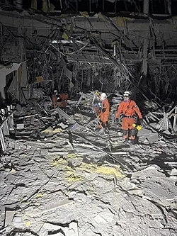
One of the most devastating incidents occurred at the Aeon Mall Kumamoto in Kashima. The second floor of the mall collapsed, followed by an explosion suspected to be caused by a gas leak. Despite the evacuation of 3,000 shoppers, employees who returned to the building were caught in the blast. Rescuers recovered seven bodies and five survivors from the wreckage; approximately 55 people were injured in the explosion.
Widespread Damage
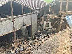
- Housing: 179 homes completely collapsed and 1,269 were damaged across Kyushu, with the vast majority in Kumamoto. In Hikawa alone, 125 buildings collapsed.
- Cultural Heritage: Kumamoto Castle, which was undergoing restoration following the 2016 quakes, suffered further damage with stone walls collapsing in 40 locations.
- Utilities: Approximately 48,300 households in Kumamoto lost power, and 84,000 households across Kumamoto and Nagasaki prefectures lost water access.
Transport and Industrial Disruptions
The earthquake paralyzed regional logistics. JR Kyushu reported over 200 instances of snapped rails and collapsed sound barriers. A freight train derailed near Yatsushiro Station, and several passengers on the Kyushu Shinkansen sustained injuries. While some services resumed by July 31, the section between Kumamoto and Shin-Minamata was expected to remain closed through August due to heavy damage.
Air travel was also affected; Kumamoto Airport closed its runway for inspections on July 28, cancelling all domestic flights for the day.
The industrial sector faced significant shutdowns. Major semiconductor facilities, including those operated by Sony, Renesas Electronics, and Tokyo Electron in Kumamoto, halted operations indefinitely. Automotive giants Toyota, Honda, and Nissan also suspended operations at various plants in Fukuoka and Ozu due to logistical failures and supplier issues.
Emergency Response and Environmental Challenges
Prime Minister Sanae Takaichi deployed over 4,600 Japan Self-Defense Forces (JSDF) personnel and 480 police officers to lead rescue operations. However, efforts were severely hampered by a concurrent extreme heatwave, with temperatures reaching 35°C to 40°C (95°F to 104°F).
The heat created a secondary crisis for the 10,000 displaced people. The JSDF airlifted air coolers to 400 evacuation centers, and authorities issued strict heatstroke warnings. Water scarcity became critical, with residents limited to 3 litres per day and SDF trucks delivering water to community centers. Fuel shortages further complicated the situation, as those sheltering in cars struggled to maintain air conditioning.
Event Summary
| Category | Details |
|---|---|
| Date & Time | July 28, 2026, 16:27:15 JST |
| Magnitude | 6.8 (USGS) / 7.1 (JMA) |
| Epicenter | 5 km East of Uto, Kumamoto Prefecture |
| Max Intensity | JMA 7 (MMI IX) |
| Fault Type | Hinagu Fault (Strike-slip) |
| Casualties | 36 deaths, 134 injuries |
| Key Infrastructure Damage | Aeon Mall collapse/explosion, Kumamoto Castle, Kyushu Shinkansen |