2004 Christmas Eve Winter Storm: A Rare Meteorological Event
In December 2004, a rare and powerful weather system swept across the United States, delivering an extraordinary White Christmas to regions where snow is seldom seen. Starting as a surface cyclone in the Gulf of Mexico, the storm tracked northeast, leaving a trail of shattered weather records from the deep South Texas coast to the shores of New England.
This event was distinct from another historic cyclone that had impacted the Midwest and southern Canada around December 23. The Christmas Eve storm was characterized by a thin band of snowfall and unusually frigid temperatures, marking the most significant snowfall for the Texas Gulf Coast and deep South Texas since February 1895.
Key Facts
- Duration: Formed December 24, 2004; dissipated December 28, 2004.
- Lowest Pressure: 964 hPa (mbar).
- Maximum Snowfall: 18 inches (45.7 cm) in Brewster, Massachusetts.
- Rarity: Produced the first measurable snow in Brownsville, Texas, in over 100 years.
- Scope: Affected the South Central United States, the Mid-Atlantic, and New England.
Meteorological History and Development
Meteorologists had indications a week prior that a frontal wave—a disturbance along a weather front—in the Gulf of Mexico might track far enough south (near the 26th parallel) to bring snow to the U.S. Gulf coastline.
The storm began as a surface cyclone on December 24, triggered by a shortwave aloft (a small area of upper-level atmospheric disturbance). It moved eastward through the western Gulf of Mexico, bringing banded snowfall to the middle Texas coast. By December 26, the extratropical cyclone—a low-pressure system that derives its energy from temperature gradients—crossed the northern peninsula of Florida.
The system continued to deepen as it moved offshore, paralleling the Southeast coast. By December 27, it had evolved into a powerful nor'easter offshore of Atlantic Canada before finally moving out to sea.
Impacts on Texas and Louisiana
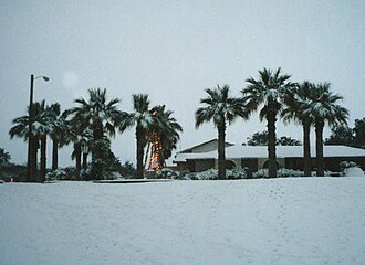
The most striking aspect of the storm was the accumulation of snow in southern Texas and southwestern Louisiana. While airborne flurries occur occasionally in these regions, they typically melt on contact. In 2004, however, the snow stuck, creating a landscape completely foreign to the region.
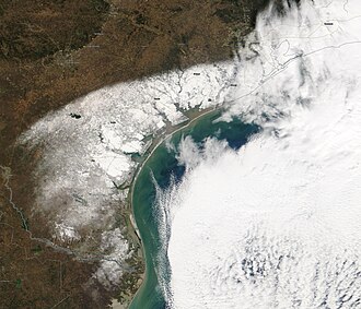
In Brownsville, Texas, 1.5 inches of snow fell, the first measurable amount since the Great Blizzard of 1899. Corpus Christi saw 5.2 inches, exceeding the total of all previous recorded years combined. Victoria, Texas, experienced a massive 13.0 inches of accumulation. New Orleans, Louisiana, celebrated its first white Christmas in 50 years.
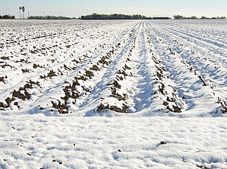
The snowfall was so widespread that it was reported even over the open waters of the Gulf of Mexico. For Houston, this represented the first significant snowfall since February 12, 1960.

Regional Snowfall Totals
| Location | Snowfall (Inches) | Snowfall (Centimeters) |
|---|---|---|
| Victoria, TX | 13.0 | 33.0 |
| Alice, TX | 12.0 | 30.48 |
| Sandia, TX | 12.0 | 30.48 |
| El Campo, TX | 11.0 | 27.9 |
| Mathis, TX | 11.0 | 27.9 |
| Beeville, TX | 10.0 | 25.4 |
| Kingsville, TX | 6.0 | 15.24 |
| Corpus Christi, TX | 5.2 | 13.2 |
| Galveston, TX | 4.0 | 10.16 |
| McAllen, TX | 4.0 | 10.16 |
| Houston, TX | 1.0 | 2.5 |
| Brownsville, TX | 1.5 | 3.8 |
| Lake Charles, LA | 1.2 | 3.1 |
| New Orleans, LA | 0.7+ | 1.8+ |
Effects Across the Eastern United States
As the storm tracked northeast, it brought varying degrees of winter weather to the East Coast:
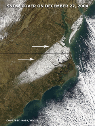
- Georgia and South Carolina: Augusta and Aiken recorded up to an inch of sleet and freezing rain.
- North Carolina: Ahoskie reported the state's highest total at 9.5 inches.
- Virginia: The Tidewater region saw over a foot of snow in some areas, with Quinby and Tabb reaching 14 inches. This was driven by frontogenesis—the strengthening of a temperature gradient—within the cyclone's comma head.
- Maryland and New Jersey: Light to moderate snow fell, with Shelltown, MD recording 4.5 inches and Mount Holly, NJ recording 2 inches.
- New York: Southeastern sections were impacted, with East Hampton seeing 8.7 inches.
New England Impact
The storm reached its peak intensity as it moved through New England. Massachusetts bore the brunt of the system, with Brewster recording the event's maximum snowfall of 18 inches. Other totals included 8.2 inches in Tiverton, Rhode Island, 9 inches in Salem, New Hampshire, and 13 inches in Whiting, Maine. Vermont also saw snowfall, including 6 inches at a dairy farm in Franklin.
Frequently Asked Questions
Was this the same storm that hit the Midwest on December 23?
No. The Midwest and southern Canada were hit by a separate cyclone that preceded the Christmas Eve storm.
How rare was the snowfall in South Texas?
It was extremely rare. In many areas, such snowfall occurs only once every twenty years, and for some locations like Brownsville, it was the first measurable snow in over a century.
What caused the heavy snow in Virginia?
The heavy snow was caused by frontogenesis (the strengthening of a temperature gradient) within the comma head of the extratropical cyclone between the 500 hPa and 700 hPa atmospheric layers.
Where was the heaviest snowfall recorded during the entire event?
The highest snowfall was recorded in Brewster, Massachusetts, which measured 18 inches (46 cm).
Did the storm affect the Gulf of Mexico waters?
Yes, moderate to heavy snowfall was reported over the open waters of the Gulf of Mexico.