Synoptic Meteorology: Analyzing Large-Scale Weather Systems and Fronts
In the field of meteorology, the synoptic scale—also referred to as the large scale or cyclonic scale—describes weather phenomena spanning horizontal distances of 1,000 km (620 mi) or more. This scale is essential for understanding the mid-latitude depressions and massive pressure systems that dictate much of the Earth's weather patterns. The term "synoptic" itself is derived from the Ancient Greek word sunoptikós, meaning "seen together," reflecting the ability to view these vast systems as a whole.
These large-scale systems are primarily driven by Rossby waves, which are giant meanders in high-altitude winds. Low-pressure areas and their associated frontal zones typically form on the leading edge of a trough within a Rossby wave pattern, while high-pressure areas develop on the back edge. Because most precipitation occurs near these frontal zones, understanding synoptic-scale movement is vital for weather forecasting.
Key Facts
- Synoptic Scale: Horizontal lengths of 1,000 km or more.
- Driving Force: Rossby waves influence the placement of high and low-pressure systems.
- Extratropical Cyclones: Mid-latitude systems characterized by temperature and dew point gradients (baroclinic zones).
- High Pressure (Anticyclones): Generally associated with clear skies and sinking air (subsidence).
- Low Pressure (Cyclones): Often associated with precipitation and frontal boundaries.
Surface Weather Analysis
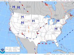
A surface weather analysis is a specialized map that provides a snapshot of weather elements across a geographic area at a specific time. By plotting data from ground-based stations—such as sea level pressure, temperature, and cloud cover—meteorologists can identify critical synoptic-scale features like weather fronts.
The history of these maps is closely tied to technological advancement. While 19th-century maps were drawn after the fact to study storm theories, the invention of the telegraph allowed for simultaneous observations. The Smithsonian Institution began producing real-time surface analyses in the late 1840s, and the use of the Norwegian cyclone model for frontal analysis became widespread in Europe during the late 1910s, eventually reaching the United States during World War II.
Interpreting Weather Maps
Weather maps utilize specific symbols to communicate complex data quickly. An H represents a high-pressure system, typically implying fair weather, while an L denotes low pressure, which often brings precipitation. Isobars—lines of equal atmospheric pressure—are used to map surface boundaries, while streamline analyses are frequently employed in tropical regions.
| Feature | High Pressure (Anticyclone) | Low Pressure (Cyclone) |
|---|---|---|
| Typical Weather | Clear skies, fair weather | Precipitation, clouds |
| Vertical Motion | Subsidence (sinking air) | Ascent (rising air) |
| Air Mass Effect | Can cause drying via adiabatic heating | Associated with frontal zones |
| Map Symbol | H (or A in Spanish) | L |
Extratropical Cyclones and Mid-Latitude Depressions
An extratropical cyclone is a synoptic-scale, low-pressure system that occurs outside the tropics. Unlike tropical cyclones, these systems are connected to fronts and horizontal gradients in temperature and dew point, known as baroclinic zones. Because they form in the middle latitudes, they are often called mid-latitude cyclones or simply "depressions."
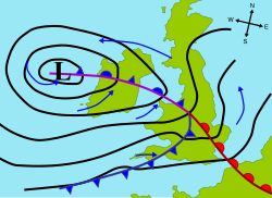
While most extratropical cyclones are baroclinic, they can become barotropic late in their life cycle if the temperature distribution around the center becomes uniform. Under certain conditions—such as dwelling over warm waters and developing central convection—an extratropical cyclone may transition into a subtropical storm and eventually a tropical cyclone.
High-Pressure Systems and Anticyclones
High-pressure systems, or anticyclones, are characterized by subsidence, which is the sinking of air through the lower troposphere. As air sinks, it undergoes adiabatic heating (compressional heating), which dries out the air mass and typically results in clear skies. However, this can lead to temperature extremes: clear days allow more solar radiation to heat the surface, while clear nights allow heat to escape more easily, leading to cooler temperatures.
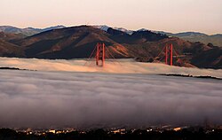
In urban areas, light winds under a high-pressure ridge can cause a buildup of particulates, resulting in haze. If humidity rises near 100% overnight, fog may form.
Variations in High Pressure
The weather brought by an anticyclone depends heavily on its origin. Strong, shallow high-pressure systems moving from higher latitudes can bring continental arctic air masses, which may cause "anticyclonic gloom" due to persistent stratocumulus or stratus clouds. Conversely, high-pressure systems that build to the north and extend south often bring very clear weather because they are cooled at the base, preventing cloud formation.
Weather Fronts: The Boundaries of Air Masses
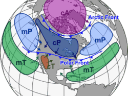
A weather front is a boundary separating two air masses of different densities, temperatures, and humidity levels. These boundaries are the primary drivers of meteorological phenomena.
- Cold Fronts: Often feature narrow bands of thunderstorms and severe weather. They generally move west to east and move faster than warm fronts due to the higher density of the air in their wake.
- Warm Fronts: Usually preceded by fog and stratiform precipitation. These typically move poleward.
- Occluded Fronts: Form when a cold front overtakes a warm front; these also generally move west to east.
- Stationary Fronts: Occur when the density contrast vanishes, resulting in a shearline that separates regions of differing wind velocity.
Frequently Asked Questions
What is the difference between a synoptic scale and a mesoscale?
The synoptic scale refers to very large weather systems spanning 1,000 km or more, such as extratropical cyclones. Mesoscale refers to smaller-scale phenomena, such as thunderstorms or squall lines.
Why does high pressure often lead to clear skies?
High pressure is characterized by subsidence, or sinking air. As the air sinks, it undergoes adiabatic heating, which increases the temperature and lowers the relative humidity, typically preventing cloud formation.
What makes an extratropical cyclone different from a tropical cyclone?
Extratropical cyclones are driven by temperature and dew point gradients (baroclinic zones) and are associated with weather fronts. Tropical cyclones are driven by central convection and warm cores, typically occurring in tropical regions.
What is a baroclinic zone?
A baroclinic zone is a region characterized by strong horizontal gradients in temperature and dew point, which provides the energy needed for the formation of extratropical cyclones.
How do fronts move?
Cold fronts and occluded fronts generally move from west to east, while warm fronts tend to move poleward. The speed of movement can be influenced by mountains or warm bodies of water.