ZIP Code System: History, Structure, and Function of U.S. Postal Codes
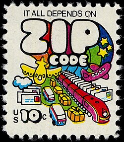
The ZIP Code, an acronym for Zone Improvement Plan, is the standardized system of postal codes utilized by the United States Postal Service (USPS). The name was intentionally chosen to evoke the idea of mail "zipping along," suggesting that the inclusion of these codes allows letters and parcels to travel more efficiently and quickly to their destinations.
While primarily used for mail routing, ZIP Codes have evolved into a critical tool for private carriers and data analysts. Today, they serve as a foundational metric for breaking down demographic, marketing, and sales data for analytical purposes.
Key Facts
- Launch Date: Introduced on July 1, 1963.
- Basic Format: A five-digit numerical code.
- Extended Format: ZIP+4 was introduced in 1983 for higher precision.
- Purpose: To streamline mail sorting and routing via Sectional Center Facilities (SCFs).
- Scope: Covers the 50 states, Puerto Rico, the U.S. Virgin Islands, and military addresses.
The Evolution of the ZIP Code
From Postal Zones to Five Digits
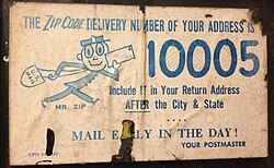
Before the modern system, the USPS used early postal zones. For example, a resident in Minneapolis might have used a zone number like "16" after the city name. On July 1, 1963, the USPS transitioned to the five-digit format. In this system, the first digit designates a broad region of the country, while the subsequent digits localize the destination further.

The Introduction of ZIP+4
To increase delivery precision, the USPS introduced ZIP+4 in 1983. This extended code consists of the original five digits followed by a hyphen and four additional digits. These extra numbers identify a specific location, such as a city block, an office building, or a specific post office box.
For PO Boxes, the add-on code often relates to the box number. It may be the last four digits of the box number, or a combination of zeros and the box number to reach four digits. However, because rules are not uniform, the USPS recommends using the official ZIP Code Lookup tool for accuracy.
How ZIP Codes are Structured
Geographic Hierarchy
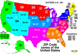
ZIP Codes are not arbitrary; they follow a specific geographic logic. The first digit represents a group of states, the second and third digits represent a Sectional Center Facility (SCF)—the mail sorting and distribution hub for that area—and the final two digits represent a specific group of delivery addresses.
Regional Allocation
The numbering generally increases from the Northeast toward the West. The lowest codes (beginning with '0') are found in New England, with the lowest overall code (00501) located in Holtsville, New York. The numbers increase southward along the East Coast, then westward and northward east of the Mississippi River, and finally northward along the West Coast, ending with the highest code (99950) in Ketchikan, Alaska.
| First Digit | Associated States/Regions |
|---|---|
| 0 | New England, New Jersey, Puerto Rico, U.S. Virgin Islands, Europe/Africa APO/FPO |
| 1 | Delaware, New York, Pennsylvania |
| 4 | Indiana, Kentucky, Michigan, Ohio |
| 5 | Iowa, Minnesota, Montana, North Dakota, South Dakota, Wisconsin |
| 6 | Illinois, Kansas, Missouri, Nebraska |
| 7 | Arkansas, Louisiana, Oklahoma, Texas |
| 8 | Arizona, Colorado, Idaho, New Mexico, Nevada, Utah, Wyoming |
Types of ZIP Codes
Not all ZIP Codes represent a geographic area. The USPS utilizes four distinct types:
- Standard: The most common type, representing a general delivery area.
- Unique: Assigned to a single high-volume address, such as a large university (e.g., Towson University 21252), a government agency (e.g., CIA 20505), or a large corporation (e.g., Walmart HQ 72716). Even individuals like Smokey Bear (20252) have unique codes.
- PO Box-only: Used exclusively for PO boxes at a specific facility. For example, Alexandria, VA uses 22313 for PO boxes and 22314 for standard street delivery.
- Military: Used to route mail to U.S. military personnel.
Operational Realities and Limitations
While based on geography, ZIP Codes actually correspond to delivery routes. This means they do not always align perfectly with local government boundaries. In some cases, a ZIP Code may cross state lines, such as ZIP Code 42223, which serves Fort Campbell across Kentucky and Tennessee.
The system is dynamic. When a community grows rapidly, the USPS may open a new SCF and reallocate prefixes. Conversely, depopulation can lead to the retirement of a code. For instance, the ZIP Code for Centralia, Pennsylvania (17927), was retired in 2002.
Frequently Asked Questions
What does ZIP stand for?
ZIP stands for Zone Improvement Plan, a name chosen to suggest that mail "zips" along more quickly when the code is used.
Is a ZIP Code the same as a city boundary?
No. ZIP Codes are designed for efficient mail routing and correspond to delivery routes rather than official municipal or geographic boundaries. Consequently, they can overlap or cross state lines.
What is a Unique ZIP Code?
A Unique ZIP Code is assigned to a single entity that receives a very high volume of mail, such as a large business, a university, or a government agency, rather than a geographic area.
How does ZIP+4 differ from a standard ZIP Code?
A standard ZIP Code is five digits and identifies a general delivery area. ZIP+4 adds four extra digits to pinpoint a more specific location, such as a specific building or a PO Box.
Can a ZIP Code be retired?
Yes. If a post office closes due to depopulation or other factors, the associated ZIP Code may be deallocated and retired from use.