Yanbian Korean Autonomous Prefecture: A Cultural and Economic Crossroads
Located in the northeast of Jilin Province, the Yanbian Korean Autonomous Prefecture serves as a unique cultural bridge in Mainland China. Characterized by its significant ethnic Korean population and its strategic border location, this region offers a fascinating blend of traditions, history, and rapid economic transformation.
The prefecture is governed from its seat in Yanji and encompasses a diverse landscape ranging from the majestic Changbai Mountains to vital river systems like the Tumen and Mudan Rivers. With a total area of approximately 43,329.3 km², it shares extensive borders with both North Korea and Russia, making it a key geopolitical and cultural junction.
Key Facts
- Prefectural Seat: Yanji
- Total Population: Approximately 2,015,500 (2022)
- Ethnic Composition: 65.79% Han, 30.77% Korean, 3.44% other
- Primary Languages: Korean and Mandarin Chinese
- Major Economic Drivers: Services, tourism, and remittances
- Bordering Countries: North Korea and Russia
Historical Evolution
The history of Yanbian is deeply intertwined with the shifting borders and migration patterns of Northeast Asia. During the Ming dynasty, the area was managed by the Jianzhou Guard. In the late Qing dynasty, it was divided into the Yanji and Hunchun subprefectures. While the Qing state initially restricted Han Chinese immigration to preserve Manchurian lands, economic opportunities eventually led to mass migration in the 19th century.
The modern administrative identity of the region began on September 3, 1952, with the establishment of the Yanbian Autonomous Region. Due to population considerations, it was later downgraded to an Autonomous Prefecture in December 1955. This status allows for the preservation of ethnic identity while remaining an integral part of Jilin Province.
The Korean Diaspora in Yanbian
The Korean presence in the region has seen dramatic shifts. In 1952, ethnic Koreans made up roughly 60% of the local population. By the 1982 census, the prefecture held over 755,000 ethnic Koreans. While the percentage of the Korean population has fluctuated—dropping to 32% by the year 2000 and reaching 35.5% by 2022—the cultural influence remains profound. The Chinese government supports this heritage through the subsidization of Korean language schools and publications.
Geography and Natural Landscape
Yanbian's geography is defined by its rugged mountains and flowing waterways. The Changbai Mountains form the central range, providing a dramatic backdrop to the prefecture. Other notable peaks include Harba Peak, Peony Peak, and Old Master Peak. The region is also home to a rich biological diversity, including 1,460 species of native animals.
Water plays a crucial role in the region's geography, with major rivers such as the Songhua, Mudan (Peony River), Tumen, and Hunchun Rivers carving through the landscape. The prefecture maintains a significant amount of green space, with seven public parks serving the local population.
Economic Transformation and Modernity
Since the 1990s, Yanbian has undergone a significant economic shift driven by China's market reforms and strengthened ties with South Korea. Following the normalization of diplomatic relations in 1992, the region saw a surge in South Korean investment and cultural exchange. This era also saw the rise of Hanggukbaram (the "Korean wind"), characterized by many Joseonjok migrating to South Korea for work.
By 2011, remittances from these migrants reached $1 billion USD annually, accounting for one-third of the prefecture's GDP. Today, the economy has transitioned from traditional farming and industry toward a robust service and tourism-based model. As of 2022, the total GDP stood at approximately CN¥ 100 billion (US$ 14.49 billion).
Administrative Structure
The prefecture is organized into eight county-level divisions, consisting of six cities and two counties:
- Cities: Yanji, Tumen, Dunhua, Hunchun, Longjing, and Helong
- Counties: Wangqing and Antu
Education and Culture
Education in Yanbian has a resilient history. During the Japanese occupation, Korean education was often linked to resistance movements. Following the occupation, there was a massive push to rebuild schools, with enrollment numbers growing significantly by 1949. In the late 1970s, a rapid expansion of Korean-language primary and middle schools occurred.
While recent decades have seen a decline in Korean-language school enrollment as students integrate into the broader Chinese educational system, the region maintains high academic standards. As of 2017, the rate of university degree holders in Yanbian was 303 per 10,000 people, more than double the national average. Notable institutions include Yanbian University of Science and Technology.
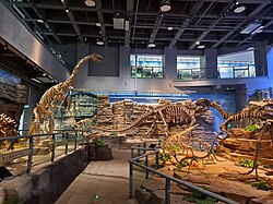
Cultural preservation is also visible in the Yanbian Museum, which houses over 10,000 exhibits. To accommodate the local population, museum labels and guides are provided in both Korean and Chinese.
Summary of Yanbian Prefecture Data
| Category | Value/Detail |
|---|---|
| Total Area | 43,329.3 km² |
| Total Population | 2,015,500 |
| GDP (Total) | CN¥ 100 billion |
| Per Capita GDP | CN¥ 40,119 |
| Urbanization Rate | 69.6% |
| Han Population % | 65.79% |
| Korean Population % | 30.77% |
Frequently Asked Questions
What is the capital of Yanbian?
The prefectural seat and capital of the Yanbian Korean Autonomous Prefecture is Yanji.
What languages are spoken in Yanbian?
The primary languages used in the region are Mandarin Chinese and Korean.
Which countries border the Yanbian Prefecture?
Yanbian shares international borders with North Korea (522.5 km) and Russia (232.7 km).
How has the economy of Yanbian changed recently?
The economy has shifted from a focus on agriculture and industry toward services and tourism, bolstered by South Korean investment and remittances.
What are the major mountain ranges in the area?
The Changbai Mountains serve as the central range, alongside others like the Zhangguangcai and Nangang Mountain Ranges.