World Geographical Scheme for Recording Plant Distributions (WGSRPD)
The World Geographical Scheme for Recording Plant Distributions (WGSRPD) is a specialized biogeographical system designed to standardize how plant distributions are recorded globally. Developed by the Biodiversity Information Standards (TDWG) organization—formerly known as the International Working Group on Taxonomic Databases—the system ensures that botanical data is disseminated effectively and consistently for the benefit of the global scientific community.
By providing a uniform set of definitions and codes, the WGSRPD allows researchers and institutions to share data without ambiguity. It is currently utilized by major organizations, including the International Union for Conservation of Nature (IUCN), the Germplasm Resources Information Network (GRIN), and Plants of the World Online (POWO).
Key Facts
- Purpose: A compromise between political boundaries and botanical traditions to standardize plant distribution recording.
- Structure: Organizes the world into four hierarchical levels, from botanical continents down to basic recording units.
- Coding: Uses numerical codes for higher levels (Continents and Regions) and alphabetic codes for lower levels (Areas and Units).
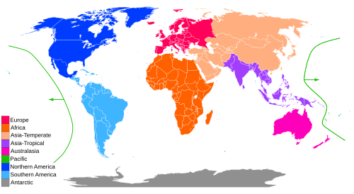
- Scope: Defines nine distinct botanical continents, some of which differ from traditional geographical continents.
- Adoption: Used by leading botanical databases and conservation bodies like Kew and the IUCN.
Principles of Organization
The WGSRPD was created to address the need for an agreed-upon system of geographical units at the country level and above. To achieve this, the scheme balances political borders with botanical reality. While most boundaries follow coastlines or political borders (such as provinces or countries), the system prioritizes botanical tradition when necessary.
This means the scheme often aligns with established works like Flora Europaea or Flora Malesiana. For example, the eastern Aegean islands (including Rhodes, Samos, and Lesbos) are placed in the West Asia region rather than Europe, reflecting their floristic characteristics despite their political status as part of Greece.
The Four Levels of Distribution
The system categorizes geographic locations across four scales of increasing detail:
- Continental: Nine botanical continents.
- Regional: Subcontinental divisions (between two and ten per continent).
- Area (Botanical Country): Units generally equating to political countries, though some large islands are treated as single entities.
- Basic Recording Units: The lowest level, used only for very large countries to subdivide them into political states or provinces.
Numerical codes identify Levels 1 and 2, while alphabetic codes identify Levels 3 and 4.
Summary of WGSRPD Hierarchy
| Level | Name | Coding Type | Example |
|---|---|---|---|
| 1 | Botanical Continent | Numerical (1 digit) | 1 (Europe) |
| 2 | Subcontinental Region | Numerical (2 digits) | 10 (Northern Europe) |
| 3 | Area / Botanical Country | Alphabetic (3 letters) | NWG (New Guinea) |
| 4 | Basic Recording Unit | Alphabetic (5 letters) | NWG-IJ (Irian Jaya) |
Detailed Breakdown of Botanical Continents
1. Europe
Defined broadly, including Iceland and Svalbard. While it follows traditional geography for the most part, it excludes Novaya Zemlya and places the Caucasus, Turkey (east of the Bosporus), Cyprus, and the Eastern Aegean Islands into West Asia based on floristic data.
2. Africa
Closely matches the geographical continent but excludes the Sinai Peninsula (assigned to West Asia). It includes the Socotra Archipelago and Macaronesia (Azores, Madeira, Canary Islands, Savage Islands, and Cape Verde).
3. Asia-Temperate & 4. Asia-Tropical
For convenience, the geographical continent of Asia is split into two botanical continents. Asia-Temperate covers the north and west, while Asia-Tropical covers the south and east. The latter includes the Indian Subcontinent, Indo-China, Malesia, and Papuasia (which includes New Guinea and Near Oceania).
5. Australasia & 6. Pacific
Australasia is limited to Australia, New Zealand, and small outlying islands. The Pacific continent consists of the central Pacific islands, including Hawaii, Fiji, and New Caledonia.
7. Northern America & 8. Southern America
The Americas are divided differently than traditional geography. Northern America includes all of Mexico, the USA, Canada, and Greenland. Southern America encompasses the Caribbean, Central America (countries between Mexico and Colombia), and the South American continent.
9. Antarctic
Includes the Antarctic continent and Subantarctic Islands such as South Georgia, the Falkland Islands, and Tristan da Cunha.
Phytogeography and Technical Application
For researchers requiring more botanically focused classifications, the WGSRPD endorses the use of phytogeography (the study of the geographic distribution of plant species). Specifically, it supports the use of floristic kingdoms, regions, and provinces as classified by Armen Takhtajan.
In practice, these codes allow for precise database entries. For instance, the distribution of Magnolia grandiflora in the GRIN database is listed by its Level 1 continent (Northern America) and Level 2 regions (Southeastern and South-Central U.S.A.), with Level 3 areas identifying specific US states.
Frequently Asked Questions
How does the WGSRPD differ from traditional geography?
The WGSRPD prioritizes botanical and floristic similarities over political borders. For example, it splits Asia into two continents (Temperate and Tropical) and places certain Greek islands in Asia rather than Europe.
What are the four levels of the WGSRPD?
The levels are Continental (Level 1), Regional (Level 2), Area or Botanical Country (Level 3), and Basic Recording Units (Level 4).
Which organizations use this system?
It is used by the International Union for Conservation of Nature (IUCN), the Germplasm Resources Information Network (GRIN), and Plants of the World Online (POWO) via the World Checklist of Vascular Plants.
What is the difference between Level 3 and Level 4 codes?
Level 3 uses a three-letter code (e.g., NWG for New Guinea). Level 4 adds a two-letter suffix to subdivide that area (e.g., NWG-IJ for Irian Jaya) or uses "-OO" if the Level 4 unit is identical to the Level 3 area.
Why was the boundary of Northern America changed in the second edition?
In the first edition, part of south-eastern Mexico was placed in Southern America. This was changed in the second edition to include all of Mexico in Northern America to better align with the preferences of Mexican botanists.