Macaronesia: The Volcanic Archipelagos of the North Atlantic
Located in the North Atlantic Ocean off the coasts of Europe and North Africa, Macaronesia is a stunning collection of four volcanic archipelagos. These islands were formed by seamounts—underwater mountains—on the ocean floor that eventually rose above the surface through intense volcanic activity.
The name itself carries a poetic history. Derived from the Greek words makárōn nēsoi, meaning "islands of the fortunate," the term was used by Ancient Greek geographers to describe any islands west of the Strait of Gibraltar. While the name fell out of common usage for centuries, it was revived in 1917 to define this specific biogeographical region.
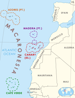
Key Facts
- Composition: Comprises the Azores, Madeira, Canary Islands, and Cape Verde.
- Origin: Entirely volcanic, created by geologic hotspots.
- Population: Approximately 3.22 million people (as of 2022).
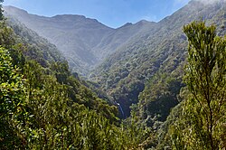
- Unique Flora: Home to the laurisilva, a relict mountain cloud forest.
- Tectonics: Mostly situated on the African tectonic plate, with the Azores at a triple junction of three plates.
Political and Geographic Distribution
Although they share geological similarities, the archipelagos are divided among different political entities. The Azores and Madeira are autonomous regions of Portugal, and the Canary Islands are an autonomous community of Spain. Cape Verde, a former Portuguese colony, is a sovereign state and a member of the United Nations.
This political divide extends to international unions: the Portuguese and Spanish islands are part of the European Union, while Cape Verde is a member of the African Union. Geologically, most of the region sits on the African tectonic plate, though the Azores occupy a complex triple junction between the Eurasian, African, and North American plates.
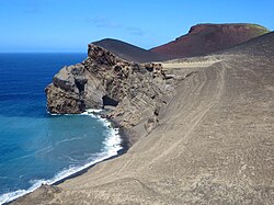
Demographics and Biogeography
As of 2022, the combined population of Macaronesia was estimated at 3,222,054. The Canary Islands hold the largest share with 2,172,944 residents (67%), followed by Cape Verde (17%), Madeira (8%), and the Azores (7%).
Biogeographically, the region is diverse. The European Environment Agency classifies the EU-member archipelagos as the Macaronesian Biogeographic Region. However, the World Geographical Scheme for Recording Plant Distributions places the entire region within the botanical continent of Africa. Specifically, Cape Verde is categorized in the Afrotropical realm, while the other three belong to the Palearctic realm.
Climate and Natural History
The varied relief and altitudinal ranges of these islands create a wide spectrum of climates. The Azores experience oceanic, Mediterranean, and humid subtropical climates; Madeira features tropical savanna climates; the Canary Islands range from desert to semi-desert; and Cape Verde maintains a tropical climate.
One of the most significant features of the region is the laurisilva. These are mountain cloud forests consisting of relict plant species—species that survived from an earlier era. These forests once covered much of the Mediterranean Basin before the region became drier. Because the Macaronesian islands were never connected to a continent, all native plants and animals arrived via long-distance dispersal, leading to a high number of endemic species (species found nowhere else on Earth).
Summary of Macaronesian Archipelagos
| Archipelago | Political Status | Primary Climate Types | Approx. Population (2022) |
|---|---|---|---|
| Canary Islands | Spain (EU) | Desert, Semi-desert | 2,172,944 |
| Cape Verde | Sovereign State (AU) | Tropical | 561,901 |
| Madeira | Portugal (EU) | Tropical Savanna | 250,769 |
| Azores | Portugal (EU) | Oceanic, Mediterranean, Humid Subtropical | 236,440 |
Conservation Challenges
Human activity has significantly impacted the native landscapes. The felling of forests for timber, land clearing for agriculture and grazing, and the introduction of non-native species have reduced the laurisilva forests to small, disconnected pockets. This fragmentation has left many endemic species endangered or extinct.
A particularly severe threat is the presence of introduced predators, specifically domestic and feral cats. These felines prey on introduced rodents and rabbits; however, the abundance of these prey species sustains a large cat population. This leads to hyperpredation, where the oversized predator population puts unsustainable pressure on native birds and reptiles.
To combat these losses, the European Union has implemented conservation efforts since 2001 under the Natura 2000 regulations. These mandates have protected approximately 5,000 km (1,900 sq mi) of land and sea across the Azores, Madeira, and the Canary Islands.
Frequently Asked Questions
What does the name Macaronesia mean?
The name is derived from the Greek makárōn nēsoi, which translates to "islands of the fortunate." It was originally used by Ancient Greek geographers to describe islands west of the Strait of Gibraltar.
How were the islands of Macaronesia formed?
The islands are volcanic in origin, created by geologic hotspots on the ocean floor. Seamounts rose from the seabed until their peaks broke the ocean's surface.
What is laurisilva?
Laurisilva is a type of mountain cloud forest composed of laurel-leaved trees. These forests are relicts of the vegetation that once covered the Mediterranean Basin before the ice ages caused the region to cool and dry.
Which tectonic plates influence the region?
Most of Macaronesia is located on the African tectonic plate. However, the Azores are uniquely positioned at the triple junction where the African, Eurasian, and North American plates meet.
What is the main threat to the islands' native wildlife?
Beyond habitat loss, introduced predators—particularly feral cats—pose a major threat. Through a process called hyperpredation, large cat populations sustained by introduced rodents also prey heavily on endemic birds and reptiles.