White Roding: A Comprehensive History of an Essex Parish
Nestled in the heart of Essex, White Roding is a village with a rich tapestry of medieval origins and ecclesiastical significance. Its name, derived from "Rodinges" as recorded in the Domesday Book, evolved over centuries. The prefix "White" is traditionally believed to refer to the striking whiteness of the parish church walls when they were first constructed.
While White Roding itself does not appear in the Domesday survey, the small manor of Morrell Roding—which was later incorporated into the parish—was listed within the Hundred of Ongar. This early settlement was centered around Cammas Hall (also known as Cammass) at the northern edge of the parish.
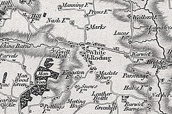
Key Facts
- Etymology: Named after the "Rodinges" people; "White" refers to the color of the church.
- Domesday Record: Morrell Roding was listed with 11 households, including villagers, smallholders, and one slave.
- Ecclesiastical Center: St Martin's Church serves as the focal point of the parish.
- Historical Manors: The area historically comprised three manors: White Roding Bury, Maskel's Bury, and Morrell.
- Agricultural Base: Historically dominated by wheat, barley, and bean farming on heavy clay soil.
Medieval Origins and Manorial Lordship
The early administration of the land saw significant shifts in ownership. Before the Norman Conquest, lordship was held by Saemer. Following the conquest, it passed to Thorgisl under Eudo Dapifer, a Tenant-in-chief to William the Conqueror. By the late 13th century, Edward I granted the manor and the advowson (the right to appoint a parish priest) to John de Merks and his sister, Cecily de Hastings.
Throughout the 14th and 15th centuries, patronage of the parish shifted through several prominent families, including the Cusances, the Quentons, and Sir Henry Green. By the 16th century, the Brown family held significant influence, with Humfry Brown and later Wiston Brown managing the manor and advowson.
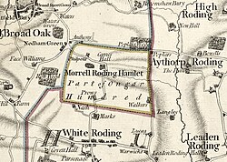
The Rectory and Parish Life
The spiritual and financial life of the village revolved around St Martin's Church. In the 17th century, the parish was part of the Archdeaconry of Middlesex and the Deanery of Dunmow. A notable figure in the church's history was the Rev Sir Charles Leventhorpe, who served as priest for an extraordinary 63 years.
Financial support for the church came from glebe land (land assigned to the support of the priest) and tithes—a tax consisting of one-tenth of agricultural produce. These tithes were meticulously detailed, covering everything from the tenth sheaf of wheat to a specific number of cheeses from households with two milking cows. By 1839, these traditional tithes were commuted to a fixed annual payment of £600 under the Tithe Commutation Act 1836.
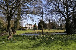
Village Infrastructure and Economy
By the 19th century, White Roding was a self-sufficient community. Records from 1800 describe the village as having a mill, two shops, and several substantial farmhouses. The village featured unique manorial traditions; for instance, White Roding Bury was used for keeping lanar falcons for the King's heron hawking, while Maskel's Bury kept greyhounds to assist in the hunt.
The local economy was diverse, supporting a variety of skilled trades. In addition to farming, the village employed blacksmiths, shoemakers, wheelwrights, and tailors. The Black Horse and Whalebone public houses were staples of social life from 1848 through 1914. The village also maintained a corn mill that utilized both wind and steam power by 1894.
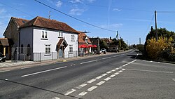
Social Development and Population
Education and social welfare evolved steadily. A Public Elementary School for 99 children was established in 1873, and a Congregational chapel opened in 1888. For the impoverished, the Dunmow Union provided relief starting in the 1830s, managed by a relieving officer who assessed the needs of applicants.
The population remained relatively stable over the late 19th and early 20th centuries, fluctuating between approximately 370 and 490 residents. The land area also saw adjustments, growing to 2,540 acres by 1914 when including Morrell Roding.
| Year | Total Population | Total Land Area (Acres) |
|---|---|---|
| 1841 | 488 (incl. Morrell Roding) | 1,853 (1848 data) |
| 1881 | 398 (incl. Morrell Roding) | 1,790 (1882 data) |
| 1901 | 373 (incl. Morrell Roding) | 2,535 (1894-1902 data) |
| 1911 | 388 (incl. Morrell Roding) | 2,540 (1914 data) |
Frequently Asked Questions
Why is the village called "White" Roding?
The name is believed to have been derived from the whiteness of the parish church walls when the building was new.
What was the role of the "relieving officer" in the village?
The relieving officer was responsible for visiting individuals applying for poor relief under the Poor Law, assessing their situation, and determining the type of assistance they should receive.
What were the primary crops grown in the parish?
The heavy clay soil of the region was primarily used for growing wheat, barley, and beans.
What happened to the Morrell Roding parish church?
The church of the former Morrell parish no longer exists; it was eventually converted into a pigeon house.
Who were some of the notable rectors of White Roding?
Notable rectors include John Maryon, who served in the early 18th century, and John Ellerton, a recognized hymnologist and hymn writer who served in 1886.