Water Table Dynamics: Mechanics, Fluctuations, and Environmental Impact
Beneath the surface of the earth lies a complex system of water storage and movement. At the heart of this system is the water table, the upper boundary of the phreatic zone, also known as the zone of saturation. In this zone, every available pore and fracture in the ground is completely filled with groundwater, which can be fresh, saline, or brackish depending on the local geography.
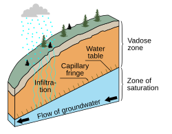
To visualize this, imagine the ground divided into two primary sections: the saturated zone below and the vadose zone (the unsaturated zone) above. The water table acts as the dividing line between these two regions.
How the Water Table Forms and Functions
Groundwater typically originates from precipitation that infiltrates the soil or from distant water flowing into an aquifer—a layer of permeable rock capable of yielding water. As water moves downward through the vadose zone, it fills more pore spaces until it reaches the zone of saturation.
In coarse soils, the water table settles where the water pressure head equals atmospheric pressure. However, in soils with strong capillary action, water is pulled upward, creating a capillary fringe—a transition layer just above the water table where the soil remains saturated due to surface tension.
Water Table vs. Water Level
While often used interchangeably, "water table" and "water level" are scientifically distinct. In a confined aquifer—where a lower permeable unit prevents upward flow—the water level in a well may rise above the actual water table. This elevation is driven by pressure and is known as the potentiometric surface.
Surface Topography and Groundwater Flow
The water table is rarely a flat plane; instead, it generally reflects the relief of the land surface. Groundwater flows from areas of higher pressure to lower pressure, typically moving both horizontally and vertically. The slope of this surface is called the hydraulic gradient, which is determined by the permeability of the material and the rate at which water enters and leaves the aquifer.
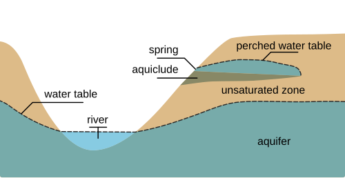
However, the water table does not always mirror the surface topography perfectly. Geological anomalies, such as faulted or folded bedrock, can alter its shape. When the water table intersects the land surface, it creates natural features such as springs, lakes, oases, and rivers. These groundwater contributions are essential for maintaining the base-flow levels of surface water bodies.
Perched Water Tables
Occasionally, a perched water table forms above the regional water table. This happens when an aquiclude (an impermeable layer) or an aquitard (a relatively impermeable layer) traps water above the main aquifer. If the flow from a perched aquifer reaches a valley wall or surface opening, it discharges as a spring.
Factors Causing Water Table Fluctuations
The depth of the water table is dynamic and changes based on several environmental factors:
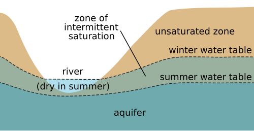
- Seasonal Changes: In regions like California or Great Britain, higher winter precipitation recharges the groundwater, while summer evapotranspiration lowers it. This range of movement is called the zone of intermittent saturation.
- Tidal Influence: On porous oceanic islands, freshwater forms a lens on top of denser seawater. This freshwater lens rises and falls in synchronization with the tides.
- Long-term Depletion: In deserts, fossil water exists in aquifers having remained for millennia. Because this water is too deep to be recharged by modern rainfall, any extraction causes a permanent drop in the water table.
Impact on Agriculture and Construction
Crop Yield and Sensitivity
The depth to the water table (DWT) is critical for agricultural productivity. If the water table is too shallow, certain crops suffer yield declines due to lack of aeration in the root zone.
![A plot of sugarcane yield versus depth of water table in Australia. The critical depth is 0.6 m.[4][5]](/images/70/19/7019701ad60b3e08fd07c099f957993143e0dd1ad79f679aa0d699fe3cbf18e1.png)
| Crop and Location | DWT Tolerance (cm) | Classification | Explanation |
|---|---|---|---|
| Wheat, Nile Delta, Egypt | 45 | Very tolerant | Resists shallow water tables |
| Sugar cane, Australia | 60 | Tolerant | Water table should be deeper than 60 cm |
| Banana, Surinam | 70 | Slightly sensitive | Yield declines at water tables < 70 cm |
| Cotton, Nile Delta | 90 | Sensitive | Requires "dry feet"; water table must be deep |
Engineering and Construction Challenges
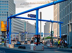
A high water table complicates excavation, foundation stability, and the installation of leach fields. When construction reaches the capillary fringe, groundwater must be actively removed. A prime example is Berlin, built on sandy, marshy ground with a water table typically 2 meters below the surface. In this city, blue and pink pipes are commonly used to pump groundwater from construction sites into canals or the Spree river.
Key Facts
- The water table is the boundary between the unsaturated vadose zone and the saturated phreatic zone.
- Aquifers are permeable rock layers that yield groundwater.
- The hydraulic gradient is the slope of the water table, influencing the direction of groundwater flow.
- Perched water tables occur when impermeable layers trap water above the regional aquifer.
- Fossil water is a non-renewable resource found primarily in deserts.
- Crop sensitivity varies; for example, cotton is highly sensitive to shallow water tables (requiring >90 cm depth), while wheat is very tolerant.
Frequently Asked Questions
What is the difference between the water table and the potentiometric surface?
The water table is the actual upper surface of the saturated zone in an unconfined aquifer. The potentiometric surface is the level to which water would rise in a well tapping into a confined aquifer, driven by internal pressure.
How does a perched water table differ from a regular one?
A regular water table is the regional boundary of saturation. A perched water table is a localized zone of saturation that sits above the regional table, held up by an impermeable layer of rock or sediment.
Why does the water table fluctuate seasonally?
Fluctuations occur due to the balance between recharge (precipitation infiltrating the soil) and discharge (evapotranspiration and flow into rivers). Higher rainfall in winter typically raises the table, while summer dryness lowers it.
Can a high water table damage crops?
Yes. Many crops require a minimum depth to the water table to ensure root aeration. If the water table is too shallow, sensitive crops like cotton may experience significant yield declines.
What is the capillary fringe?
The capillary fringe is a layer of saturated soil located immediately above the water table, where water is drawn upward from the phreatic zone through capillary action in small soil pores.