Washington, D.C. City Layout and Urban Design
Established in 1790 to serve as the permanent national capital of the United States, the District of Columbia represents a masterclass in 18th-century urban planning. Founded in 1791 to the east of the existing Georgetown settlement, the city was designed to be more than just a seat of government; it was envisioned as a grand architectural statement.
The Vision of Pierre Charles L'Enfant
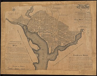
The original street layout was the work of Pierre (Peter) Charles L'Enfant. He designed the city in the Baroque style, a design philosophy characterized by grandeur and symmetry. This approach incorporated wide avenues radiating from rectangular blocks, ensuring ample room for landscaping and open public spaces.
L'Enfant did not work in a vacuum. He drew inspiration from European urbanism, utilizing plans of cities like Paris, Amsterdam, Milan, Frankfurt, and Karlsruhe provided by Thomas Jefferson. Specifically, the distribution of the central space and the twelve radiating avenues were inspired by the Spanish royal city of Aranjuez.
A centerpiece of L'Enfant's vision was a garden-lined "grand avenue," measuring approximately 1 mile (1.6 km) in length and 400 feet (120 m) in width, which now constitutes the National Mall.
![Facsimile of manuscript of Peter Charles L'Enfant's 1791 plan for the federal capital city (United States Coast and Geodetic Survey, 1887).[2]](/images/68/23/6823a503e30f75639c03923085dd5251d3c482a7d0760fde8da9869784ae3465.jpg)
Transition to Andrew Ellicott
Despite his brilliance, L'Enfant's insistence on micromanaging the planning process led to conflicts with the three commissioners appointed by President Washington. Consequently, L'Enfant was dismissed in March 1792. Andrew Ellicott, who had previously assisted L'Enfant with surveying, was commissioned to complete the plans. While Ellicott revised some street patterns, L'Enfant remains the primary architect of the city's overall design.

The Geography and Grid of the Capital
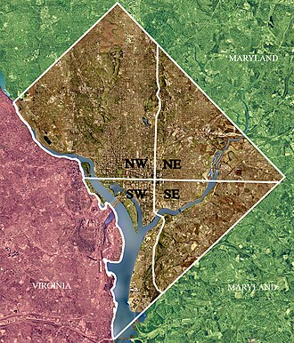
The original boundaries of the City of Washington were defined by natural and man-made markers: the Anacostia River to the southeast, the Potomac River to the southwest, Rock Creek to the west, and Boundary Street (now Florida Avenue) to the north.
To organize the city, the district was divided into four quadrants of unequal area: Northwest (NW), Northeast (NE), Southeast (SE), and Southwest (SW). These quadrants radiate from the U.S. Capitol building, which serves as the central axis of the city.
Street Naming and Navigation
The city utilizes a hybrid system of grids and diagonals. Most streets follow a standard grid where east-west streets are named with letters (e.g., C Street SW) and north-south streets are named with numbers (e.g., 4th Street NW). House numbers are determined by the approximate number of blocks from the Capitol.
The central axes are marked by Capitol Street (North, South, and East). Because the axis runs through the middle of these streets, addresses on opposite sides of the road fall into different quadrants. The western axis is defined by the National Mall, flanked by Constitution Avenue and Independence Avenue.
Diagonal avenues are frequently named after U.S. states. Notable examples include Pennsylvania Avenue, which links the White House to the Capitol, and Massachusetts Avenue, known informally as "Embassy Row" due to the high concentration of foreign embassies.
The Mystery of the Missing Letters
Visitors to the city may notice that certain letters are missing from the street grid. There is no J Street in any quadrant. Historically, the letters "I" and "J" were indistinguishable in handwriting; therefore, "I Street" is often written as "Eye Street" to avoid confusion with the letter "L" or the number "1". Similarly, "Q Street" is often written as "Que," "Cue," or "Queue." While urban legends suggest L'Enfant omitted "J" due to a feud with Chief Justice John Jay, this has been proven false.
Other omissions include the letters X, Y, and Z. Additionally, the letter B was removed: north of the Mall, B Street became Constitution Avenue in 1931, and south of the Mall, it became Independence Avenue in 1934. Because the Mall occupies the space where A Street would be, the lettered streets in these areas begin with C.
Key Facts
- Primary Designer: Pierre Charles L'Enfant, with later revisions by Andrew Ellicott.
- Architectural Style: Baroque, featuring radiating avenues and open spaces.
- Central Hub: The U.S. Capitol building serves as the origin point for the city's four quadrants.
- The Mall: Originally envisioned as a 1-mile long, 400-foot wide garden-lined avenue.
- Naming Convention: East-west streets use letters; north-south streets use numbers.
- Missing Letters: B, J, X, Y, and Z are not used in the standard lettered street sequence.
| Feature | Description |
|---|---|
| Quadrants | NW, NE, SW, SE (radiating from the Capitol) |
| Grid System | Lettered (E-W) and Numbered (N-S) streets |
| Key Avenues | Pennsylvania Ave, Massachusetts Ave, Constitution Ave |
| Influences | Paris, Amsterdam, and Aranjuez (Spain) |
| Natural Boundaries | Potomac River, Anacostia River, and Rock Creek |
Frequently Asked Questions
Why is there no J Street in Washington, D.C.?
J Street was omitted because the letters "I" and "J" were written identically until the mid-19th century. This was a practical decision to avoid confusion, not the result of a personal dispute between L'Enfant and John Jay.
Who is credited with the design of the city?
While Andrew Ellicott revised the plans and completed the work after Pierre Charles L'Enfant was dismissed in 1792, L'Enfant is still credited with the overall design and vision of the city.
How do the quadrants work in D.C.?
The city is split into Northwest, Northeast, Southwest, and Southeast quadrants. The boundaries of these quadrants radiate from the U.S. Capitol building, and every road name includes a quadrant abbreviation to specify its location.
Why do some streets have names like "Eye Street"?
"Eye Street" is a phonetic spelling of "I Street," used to distinguish it from the letter "L" or the numeral "1" in written records.
What happened to B Street?
B Street was renamed to Constitution Avenue (north of the Mall) in 1931 and Independence Avenue (south of the Mall) in 1934.