Tiwanaku: The Spiritual and Political Heart of Ancient Bolivia
Located in western Bolivia near the shores of Lake Titicaca, Tiwanaku (also known as Tiahuanaco or Tiahuanacu) stands as one of the most significant Pre-Columbian archaeological sites in South America. This sprawling complex, situated approximately 70 kilometers from La Paz, served as the spiritual and political center of the Tiwanaku culture. Today, the surface remains cover roughly 4 square kilometers, showcasing a legacy of monumental architecture, megalithic stone blocks, and intricate ceramics.
At its zenith around AD 800, it is estimated that the city housed between 10,000 and 20,000 residents. Its growth was fueled by a sophisticated agropastoral economy—a system combining crop cultivation and livestock herding—bolstered by extensive trade networks across the Andean region.
Key Facts
- Location: Tiwanaku Municipality, Bolivia, near Lake Titicaca.
- UNESCO Status: Designated as a World Heritage Site in 2000.
- Estimated Founding: Approximately AD 110 (based on modern statistical radiocarbon dating).
- Peak Population: 10,000 to 20,000 people around AD 800.
- Major Structures: Akapana, Pumapunku, and the Kalasasaya.
- Largest Artifact: The Bennett Monolith, standing 7.3 meters tall.
The Evolution of Site Dating
The chronological history of Tiwanaku has been a subject of intense academic debate. In the early 20th century, Arthur Posnansky suggested the site was between 11,000 and 17,000 years old. By the 1970s, Carlos Ponce Sanginés proposed a date of 1580 BC. However, modern consensus has shifted significantly.
Since the 1980s, researchers have found earlier dates unreliable. Recent statistical assessments of radiocarbon data and the analysis of ceramic styles suggest the site was founded around AD 110, with a 68% probability that it dates between AD 50 and 170. The culture's influence in the Titicaca basin grew between AD 200 and 500, reaching its peak between AD 500 and 600.
Monumental Architecture and Structures
Akapana
The Akapana is a massive structure shaped like a "half Andean Cross." It measures 257 meters wide and 197 meters at its maximum breadth, reaching a height of 16.5 meters. While it features a staircase on its western side and likely contained a sunken court at its center, much of the central area was destroyed by historical looting.
Pumapunku
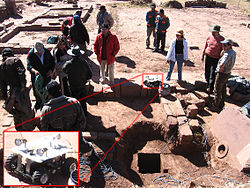
Pumapunku is a T-shaped, terraced earthen platform faced with megalithic blocks. It spans 167.36 meters north-to-south and 116.7 meters east-to-west. A defining feature is the Plataforma Lítica, a large stone terrace measuring 6.75 by 38.72 meters. This area contains the site's largest stone block, estimated by Ponce Sangines to weigh 131 metric tonnes, followed by another weighing 85 metric tonnes.
Kalasasaya and the Gate of the Sun
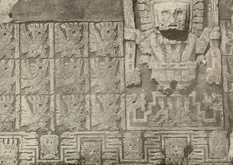
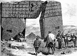
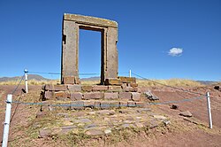
The Kalasasaya is renowned for its high-quality stonework and spiritual significance. Among its most famous features is the "Gate of the Sun," a meticulously carved megalith that has become a symbol of the Tiwanaku culture.
The Semi-Subterranean Temple and Monoliths
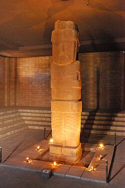
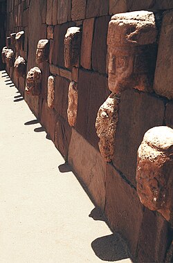
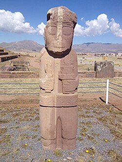
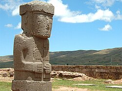
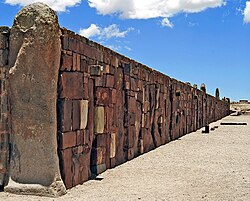
The site is also home to the Semi-Subterranean Temple, where various stone heads are embedded in the walls. This temple was the discovery site of the Bennett Monolith, the largest stele (upright stone slab) ever found in the Andean world, standing 7.3 meters tall.
Other notable carvings include the Fraile Monolith, which depicts a figure holding a Qiru (ceremonial vessel) and a snuff tray, and the Ponce Monolith.
Archaeological Exploration and Modern Discovery
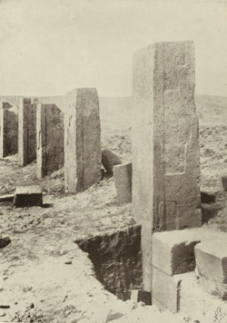
Scientific study of Tiwanaku began in the mid-19th century with the maps and sketches of Ephraim George Squier and the measurements of Alphons Stübel. In 1892, Georg von Grumbkow and Max Uhle provided the first in-depth scientific account of the ruins.
Between 1978 and the 1990s, Alan Kolata and Oswaldo Rivera conducted academically rigorous excavations. Their work led to the rediscovery of suka kollus (raised field agriculture) and provided evidence that a severe drought may have contributed to the civilization's collapse.
Recent technological advancements have revealed that the site is much larger than previously thought. Drone imaging in 2016 uncovered unknown structures spanning 411 hectares, including a 17-hectare stone temple and approximately one hundred domestic units. Additionally, UNESCO utilized Lidar and terrestrial laser scanning between 2005 and 2007 to create high-resolution topographical maps, generating over 300 million data points to redefine the site's layout.
Site Summary
| Feature | Details |
|---|---|
| Coordinates | 16°33′17″S 68°40′24″W |
| Primary Structures | Akapana, Pumapunku, Kalasasaya, Semi-Subterranean Temple |
| Key Artifacts | Gate of the Sun, Bennett Monolith, Fraile Monolith |
| Estimated Population | 10,000 – 20,000 (c. AD 800) |
| Modern Mapping Tools | Lidar, Drones, Terrestrial Laser Scanning |
Frequently Asked Questions
How old is the site of Tiwanaku?
While older theories suggested dates ranging from 1580 BC to 17,000 years ago, modern statistical radiocarbon dating and ceramic analysis indicate the site was likely founded around AD 110.
What is the significance of the Pumapunku?
Pumapunku is a megalithic platform known for its precision-cut stone blocks. It contains the largest stone block at the site, estimated to weigh 131 metric tonnes.
What caused the collapse of the Tiwanaku civilization?
Research conducted by archaeologists such as Alan Kolata suggests that a drought-based collapse played a significant role in the decline of the civilization.
What are suka kollus?
Suka kollus are raised field agricultural systems used by the Tiwanaku people to support their large population through an efficient agropastoral economy.
What new discoveries have been made recently?
Drone imaging in 2016 revealed previously unknown structures covering 411 hectares, including a large stone temple and numerous domestic units, significantly expanding the known footprint of the city.