Stanton Drew Landmarks and Historic Architecture
The village of Stanton Drew is home to a rich tapestry of architectural history, featuring structures that span several centuries. From medieval bridges to 18th-century toll houses, the village preserves a diverse array of Grade II and Grade II* listed buildings—designations used in the UK to protect structures of special architectural or historic interest.
Key Facts
- Oldest Structures: The Rectory Farmhouse and Church Farmhouse both date back to the 15th century.
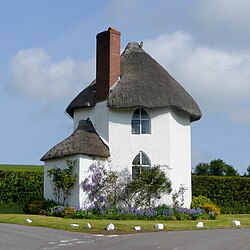
- The Round House: A late 18th-century former toll house for the West Harptree Turnpike Trust.
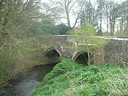
- River Chew Bridge: A limestone bridge potentially dating to the 13th or 14th century.
- Industrial Heritage: Evidence of a site that served as a forge, copper mill, and paper mill.
- The Court: A Grade II* listed building from 1753, currently operating as a nursing home.
Architectural Highlights of the Village
The Round House
Located at the northern entrance to the village, the Round House is a distinctive white, thatched building from the late 18th century. Originally constructed as a toll house for the West Harptree Turnpike Trust, it is now a private residence and a Grade II listed building. Historical records, including the 1840 Chew Magna tithe map, reveal that the building was strategically placed to block the main east-west road (now the B3130). This forced travelers to pass through one of two gates to enter the village or continue their journey. Following the abolition of the Trust in the mid-1870s, the road was reconfigured to allow traffic to pass freely to the north of the house.
The Rectory Farmhouse and The Court
Stanton Drew boasts several high-status historic residences. The Rectory Farmhouse is a Grade II* listed building dating to the 15th century, accompanied by a contemporary barn and dovecote. Similarly, The Court on Bromley Road, dating from 1753, holds a Grade II* listing. While The Court now serves as a nursing home, its surrounding walls and piers are also protected under Grade II listing.
The River Chew Bridge
Spanning approximately 12 metres (39 ft), the narrow limestone bridge over the River Chew is one of the village's most ancient features, possibly originating in the 13th or 14th century. It is designated as Ancient Monument Avon no. 162. The bridge features two pointed arches with chamfered mouldings, inner ribs to vaults, and a central cutwater with a pyramidal stone top. Despite its age, it has undergone various repairs, including the addition of an exposed steel girder on the east side, following damage during the 1968 Chew Stoke flood.
Industrial and Community Landmarks
The Watermill
The village's industrial past is evidenced by a watermill site that evolved over two centuries. In the 1660s, it functioned as a forge; from 1713 to 1860, it operated as a copper mill, and it later served as a paper mill.
War Memorial and Other Listed Sites
In the village centre, the War Memorial commemorates those who served and died in the two World Wars. The monument was rebuilt using local stone in 2021. The village also contains numerous other Grade II listed buildings, including the 15th-century Church Farmhouse, 17th-century properties such as Byemills Farmhouse and Codrington Cottage, and 19th-century homes like Mill Place and Rosedale.
Summary of Historic Buildings
| Building Name | Period/Date | Listing Status | Original/Current Use |
|---|---|---|---|
| Rectory Farmhouse | 15th Century | Grade II* | Farmhouse |
| Church Farmhouse | 15th Century | Grade II | Farmhouse |
| River Chew Bridge | 13th/14th Century | Ancient Monument | River Crossing |
| The Court | 1753 | Grade II* | Nursing Home |
| The Round House | Late 18th Century | Grade II | Toll House / Private House |
Frequently Asked Questions
What was the original purpose of the Round House?
The Round House was originally built as a toll house for the West Harptree Turnpike Trust to collect fees from traffic passing through the area.
How old is the bridge over the River Chew?
The limestone bridge is believed to date back to the 13th or 14th century, though it has undergone several repairs over time.
Which buildings in Stanton Drew have Grade II* status?
The Rectory Farmhouse and The Court are both designated as Grade II* listed buildings.
What industries were associated with the village watermill?
The watermill site was used as a forge in the 1660s, a copper mill between 1713 and 1860, and subsequently as a paper mill.
When was the village War Memorial rebuilt?
The War Memorial, which commemorates the dead of the two World Wars, was rebuilt in local stone in 2021.