Somerset Coast Route: A Journey Through History and Geology
Stretching from the hamlet of Steart on the Steart Peninsula to the town of Minehead, this coastal route offers a rich tapestry of natural beauty, ancient history, and industrial heritage. Passing through the villages of Kilve, West Quantoxhead, Williton, Watchet, Blue Anchor, and Dunster beach, the path reveals a landscape shaped by both the elements and human ambition.
Kilve and the Romantic Shore
The beach at Kilve, famously described by the Romantic poet William Wordsworth as "Kilve's delightful shore," is a place where nature and legend intersect. At Kilve Pill, where the stream from Holford meets the sea, visitors can find the remains of a stone jetty and ruins of a lime kiln. These kilns were once used to burn limestone to produce lime for local farmers to spread on their fields.
Historically, Kilve Pill served as a small port for importing culm (an inferior type of coal used in lime-burning) and was a site for "glatting," the practice of hunting conger eels with dogs. Local legend speaks of the Saint Keyne serpent—a snake turned to stone—though it is scientifically an ammonite (an extinct marine mollusk). The area's maritime history is further marked by the 1876 wreck of the limestone carrier Laurina.
The Legacy of the West Somerset Railway
Between Williton and Minehead, the route closely follows the path of the West Somerset Railway. Opened in 1862 and extended to Minehead in 1874, this line was vital for transporting the growing number of tourists visiting the Somerset coast during the early twentieth century. Although the line closed in 1971, it was revived in 1976 as a heritage railway, preserving the region's transport history.
Watchet: A Harbour of Conflict and Commerce
Watchet is a historic harbour town with a turbulent past. The Anglo-Saxon Chronicle records that the town was plundered by Danes led by Ohtor and Rhoald in 987 and 997. By 1564, the harbour was frequently used by small boats, likely importing wine and salt from France.
The town witnessed a peculiar event during the English Civil War: while Royalist reinforcements were arriving by sea for the siege of Dunster Castle, the ebbing tide left the ship vulnerable. A troop of Roundheads rode into the shallows and forced the vessel to surrender, resulting in a ship at sea being captured by cavalry.
Commerce evolved over the centuries. A pier built in the early 18th century by wool merchants supported the export of kelp (burnt seaweed used in glass making) by 1797. By the 19th century, trade expanded to include gypsum, flour, paper, and iron ore from the Brendon Hills. This trade was bolstered by two railways: the West Somerset Railway and the West Somerset Mineral Railway, the latter of which transported iron ore to the harbour for smelting at Ebbw Vale in South Wales.
Geological Wonders and Ancient Forts
The landscape around Watchet is defined by its striking geology. The cliffs between Watchet and Blue Anchor feature a pale, greenish-blue alabaster, which gave rise to the 16th-century color name "Watchet Blue." The foreshore is rocky and experiences a significant tidal range of 6 metres (20 ft).
Nearby, Daw's Castle stands 80 metres (260 ft) above the sea. While it may have originated in the Iron Age, it was fortified as a burh (a fortified settlement) by King Alfred around 878 AD to defend against Viking raids from the Bristol Channel.
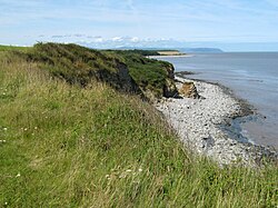
The Lilstock Formation
The Blue Anchor to Lilstock Coast is a 742.8-hectare Site of Special Scientific Interest (SSSI). It is world-renowned for the "Lilstock Formation," a series of sections through the Early Jurassic Lower Lias spanning the Hettangian and Pliensbachian Stages. This area is a treasure trove for fossil hunters, yielding shells, fish remains, and complete reptile skeletons.
One of the most significant finds is Excalibosaurus costini MacGowan, a unique ichthyosaur specimen with a lower jaw shorter than the upper. This fossil, found in the Lower Jurassic Sinemurian Stage beds, is now housed in the Bristol City Museum and Art Gallery.
Dunster Beach and the Lost Haven
Dunster Beach, where the River Avill meets the sea, was once home to Dunster Haven. From Saxon times, this harbour was a primary hub for the export of wool. However, the haven fell into disuse in the 17th century and has since disappeared beneath the marshes, meadows, and dykes.
Today, the beach is a leisure destination featuring a small shop, a tennis court, a putting green, and privately owned beach huts. These chalets, typically measuring 18 by 14 feet (5.5 by 4.3 m), serve as holiday rentals or year-round residences for some owners.
Key Facts
- Route Span: From Steart Peninsula to Minehead.
- Geological Significance: The Lilstock Formation provides critical insights into the Early Jurassic Lower Lias.
- Historical Defense: Daw's Castle was fortified by King Alfred around 878 AD against Vikings.
- Unique Fossil: The Excalibosaurus costini MacGowan ichthyosaur is a rare find from the Lilstock foreshore.
- Railway History: The West Somerset Railway transitioned from a tourist line to a heritage railway in 1976.
- Tidal Range: Watchet's foreshore experiences a high tidal range of 6 metres.
| Location | Primary Significance | Key Feature/Event |
|---|---|---|
| Kilve | Natural & Industrial | Lime kilns and "Saint Keyne serpent" ammonite |
| Watchet | Maritime & Military | Viking raids and iron ore export |
| Daw's Castle | Archaeological | King Alfred's burh against Vikings |
| Lilstock | Paleontological | Lower Lias fossils and Excalibosaurus |
| Dunster Beach | Commercial History | Former wool export hub (Dunster Haven) |
Frequently Asked Questions
What is the "Saint Keyne serpent"?
The Saint Keyne serpent is a local legend in Kilve describing a snake turned to stone; however, it is actually an ammonite fossil.
What is the significance of "Watchet Blue"?
"Watchet Blue" is a color name originating in the 16th century, derived from the pale, greenish-blue alabaster found in the cliffs between Watchet and Blue Anchor.
What makes the Lilstock Coast an SSSI?
It is a Site of Special Scientific Interest due to its outstanding geological sections of the Early Jurassic Lower Lias and its abundance of reptile, fish, and shell fossils.
How did the West Somerset Railway evolve?
Opened in 1862 and extended in 1874, it served tourists until its closure in 1971, after which it was reopened in 1976 as a heritage railway.
What happened to Dunster Haven?
Once a significant Saxon-era harbour for wool export, Dunster Haven ceased operation in the 17th century and has since been reclaimed by marshes and meadows.