Staig: A Scenic Municipality in Baden-Württemberg
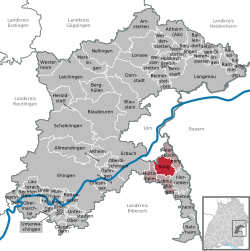
Nestled in the heart of southern Germany, Staig is a charming municipality located within the Alb-Donau-Kreis district of Baden-Württemberg. Situated on a plateau between the Danube and Iller rivers, south of the city of Ulm, Staig offers a blend of historical depth and natural beauty. The community is part of the Gemeindeverwaltungsverband-Kirchberg Weihungstal, an administrative collective headquartered in Illerkirchberg.
The region is characterized by its unique topography, specifically the landscape of the Holzstöcke. The municipality's layout is defined by the Weihung valley, with the districts of Steinberg and Altheim perched on the ridges of both sides, while other districts reside within the valley or its smaller tributaries.
Key Facts
- State: Baden-Württemberg, Germany
- District: Alb-Donau-Kreis
- Population: 3,281 (as of December 31, 2024)
- Total Area: 17.75 km²
- Elevation: 502 meters above sea level
- Current Mayor: Sascha Erlewein (CDU)
Geography and Administration
Staig is strategically positioned within the Tübingen administrative region. Its geographical boundaries are shared with several neighboring communities: Unterweiler (a district of Ulm) to the north, Illerkirchberg to the east, Illerrieden to the southeast, Schnürpflingen to the south, and Hüttisheim to the west.
The municipality is composed of six distinct districts that contribute to its local identity:
- Staig
- Altheim
- Essendorf
- Harthausen
- Steinberg
- Weinstetten
History and Evolution
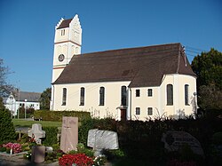
The history of Staig is reflected in the ancient records of its districts. The oldest mentioned settlement is Harthausen, which appears in documentation as early as 1093. The village of Staig itself was first recorded as "Steiga" in 1127, followed by Altheim in 1194. The remaining districts were established or recorded during the 14th century.
The modern administrative structure of the municipality was formed through a series of mergers in the 1970s. On April 1, 1972, the municipality of Steinberg was incorporated into Weinstetten. Shortly after, on October 9, 1972, Weinstetten was renamed Staig. The final major addition occurred on January 1, 1976, when Altheim ob Weihung was integrated into the community.
Community Overview
| Category | Detail |
|---|---|
| Postal Code | 89195 |
| Dialling Code | 07346 |
| Vehicle Registration | UL |
| Population Density | 184.8/km² |
| Time Zone | CET (UTC+1) / CEST (UTC+2) |
| Official Website | www.staig.de |
Frequently Asked Questions
Which is the oldest district in Staig?
Harthausen is the oldest district, appearing in historical documents as early as 1093.
Who is the current mayor of Staig?
As of 2024, the mayor is Sascha Erlewein of the CDU.
Where is Staig located geographically?
Staig is located in the Alb-Donau-Kreis district of Baden-Württemberg, Germany, on a plateau between the Danube and Iller rivers south of Ulm.
How many districts make up the municipality?
The municipality consists of six districts: Altheim, Essendorf, Harthausen, Staig, Steinberg, and Weinstetten.
When did the municipality take its current name?
The municipality was renamed Staig on October 9, 1972, following the incorporation of Steinberg into Weinstetten.