St. Bernard Parish: A History of Resilience and Heritage
Located in the southeastern corner of Louisiana, St. Bernard Parish is a region defined by its intimate relationship with water and its enduring spirit of recovery. Founded on March 31, 1807, and named after Bernardo de Galvez, the parish serves as a gateway between the Mississippi River and the Gulf of Mexico. From its role in pivotal American military history to its struggle against catastrophic natural disasters, St. Bernard is a land of profound contrasts and deep cultural roots.
Today, the parish is centered around its seat, Chalmette, and is characterized by a landscape where land and water are inextricably linked. While it has faced immense challenges, it was the fastest-growing parish in Louisiana between 2010 and 2020, signaling a steady return to growth and stability.
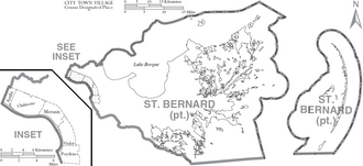
Key Facts
- Founded: March 31, 1807.
- Geography: 83% of its 2,158 square miles is water, making it the parish with the highest percentage of water area in Louisiana.
- Historical Landmark: Home to the Chalmette Battlefield, site of the 1815 Battle of New Orleans.
- Population: 43,764 (2020 Census), with an estimated 45,642 by 2025.
- Major Communities: Chalmette, Arabi, Meraux, Violet, and Delacroix.
Historical Milestones
The Battle of New Orleans
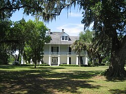
The crown jewel of the parish's historical attractions is the Chalmette Battlefield, part of the Jean Lafitte National Historical Park and Preserve. This site hosted the Battle of New Orleans on January 8, 1815, during the War of 1812. The influence of this event persists today; many local streets are named after the battle's participants or follow a pirate theme in honor of Jean Lafitte, who is remembered as a hero of the conflict. General Andrew Jackson, the commanding officer of the defense, is also honored through local educational institutions.
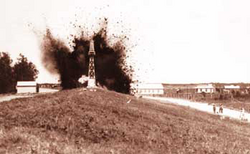
The Great Mississippi River Flood of 1927
In 1927, a catastrophic flood led New Orleans and state officials to make a controversial decision: they used dynamite to breach a levee at Caernarvon to relieve pressure and save the city of New Orleans. While residents of the city initially believed this action was necessary, historians now suggest the breach was unnecessary due to upstream breaks. The result was widespread destruction across Eastern St. Bernard Parish and parts of Plaquemines Parish, with residents never receiving adequate compensation for their losses.
The Impact of Hurricane Katrina and Hurricane Ida
On August 29, 2005, Hurricane Katrina devastated the parish. A 25-foot storm surge entered through the Mississippi River Gulf Outlet (MRGO), destroying levees and flooding nearly the entire parish with 5 to 15 feet of water. Many homes were completely washed off their foundations.
The recovery was a monumental effort. Organizations like the H.O.P.E. Project, Camp Hope, and the St. Bernard Project emerged to provide tools, housing for volunteers, and direct assistance to residents. Despite the devastation, key industrial hubs like the ExxonMobil plant in Chalmette and the Domino Sugar plant in Arabi returned to operation by December 2005.
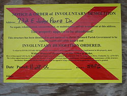
More recently, on August 29, 2021, Hurricane Ida brought heavy flooding to the region. Despite warnings of an 11-foot storm surge, local officials opted not to issue a formal evacuation order, though the parish once again faced the challenges of severe weather.
Geography and Environment
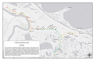
St. Bernard Parish is a landscape of alluvial lands—soil deposited by flowing water—and numerous small islands. It is the second-largest parish in Louisiana by total area, though only 378 square miles is land. The region is defined by the Bayous Terre aux Boeufs and La Loutre, and its natural canopy is dominated by the bald cypress tree.
Regional Boundaries and Protected Areas
The parish is bordered by the Gulf of Mexico to the east, Lake Borgne to the north, and the Mississippi River to the southwest. It also encompasses significant protected natural areas, including parts of the Breton National Wildlife Refuge and the Jean Lafitte National Historical Park, as well as the St. Bernard State Park.
Demographics and Community Life
The population of St. Bernard has seen dramatic shifts. After peaking at 67,229 in 2000, the population plummeted following Hurricane Katrina to 35,897 by 2010. However, a trend of diversification and growth has followed, with the 2020 census recording 43,764 residents. The community is ethnically diverse, with significant Non-Hispanic White, Black or African American, and Hispanic or Latino populations.
Religion plays a central role in community life, with the Roman Catholic Archdiocese of New Orleans being the largest religious affiliation, followed by various Baptist and non-denominational Protestant groups.
Education and Recreation
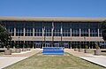
The parish's education system underwent a massive consolidation after Katrina, briefly operating as the St. Bernard Unified School (SBUS) before splitting back into several separate schools by the 2006–2007 school year. For recreation, residents utilize the Frederick J. Sigur Civic Center and the Val Riess Recreation Complex.
| Category | Detail |
|---|---|
| Total Area | 2,158 sq mi (83% Water) |
| Parish Seat | Chalmette |
| 2020 Population | 43,764 |
| Median Household Income | $44,661 |
| Primary Industry Hubs | ExxonMobil, Domino Sugar |
Frequently Asked Questions
What is the historical significance of Chalmette?
Chalmette is the site of the Battle of New Orleans (1815), a major conflict during the War of 1812 where American forces under Andrew Jackson defeated the British.
How did the 1927 flood affect the parish?
The levee at Caernarvon was intentionally dynamited to save New Orleans from flooding, which caused widespread destruction in Eastern St. Bernard Parish.
What happened to the population after Hurricane Katrina?
The population dropped significantly from 67,229 in 2000 to 35,897 in 2010, though it has since begun to recover, reaching 43,764 by 2020.
What are the main geographic features of the parish?
The parish is characterized by alluvial lands, bald cypress forests, and a very high percentage of water (83%), including various bayous and islands.
Who was Leander Perez?
Leander Perez was a powerful local Democratic official who effectively ruled the parish as part of a political fiefdom from 1919 to 1969.