Somerset Levels and Moors Water Management
The Somerset Levels and Moors represent a complex, reclaimed landscape defined by its precarious relationship with water. Geographically, the region consists of a coastal clay belt situated slightly above mean sea level, protecting an inland peat belt that sits even lower. This unique topography has necessitated centuries of engineering to transform a submerged wilderness into productive farmland and habitable settlements.
Key Facts
- Geography: Comprises a coastal clay belt and a lower-lying inland peat belt.
- Key Waterways: Managed via the Axe, Brue, Huntspill, Parrett, Tone, and Yeo rivers.
- Infrastructure: Utilizes a network of rhynes (local drainage channels) and pumping stations.
- Primary Risks: Vulnerable to both tidal surges from the Bristol Channel and freshwater winter flooding.
- Governance: Water levels are managed by Internal Drainage Boards (IDBs) and the Environment Agency.
The History of Land Reclamation
While evidence suggests the Romans may have attempted early water control, formal records of drainage date back to the 13th century. In the Middle Ages, the monasteries of Glastonbury, Athelney, and Muchelney led the effort to reclaim the land. For example, between 1234 and 1240, the Glastonbury abbey increased its reclaimed land near Westonzoyland from 722 acres (2.9 km²) to 972 acres (393 ha).
Early economic activity relied heavily on these waterways. By the 8th century, Bleadney served as a port on the River Axe, and by 1600, 15 to 20 ton barges could navigate the Parrett as far as Langport.
The Evolution of Drains and Embankments
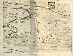
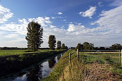
To combat flooding, 13th-century engineers constructed embankment walls such as the Southlake, Burrow, and Lake Walls to contain the River Parrett. The River Tone was also diverted into a new embanked channel. Over time, the drainage system evolved into a sophisticated network of artificial channels, including the King's Sedgemoor Drain, which now carries the River Cary.
Reclamation efforts continued through the centuries, though they often faced social opposition. In the early 17th century, plans by Sir Cornelius Vermuyden to drain Sedgemoor were thwarted by Commoners fearing the loss of grazing rights. It wasn't until the late 18th century that significant enclosures occurred; between 1785 and 1791, much of the lowest peat moors were enclosed using rhynes to drain individual plots.
Mechanical Drainage and Pumping
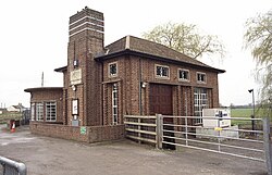
For centuries, pumping was rare due to the high cost of early steam engines. Only a few windmills were recorded, such as those at Bleadon and Common Moor. The transition to mechanical drainage began in earnest with the Westonzoyland Pumping Station in 1830, eventually evolving into the automatic electric pumps used today.
Modern engineering additions include the Huntspill River, constructed during World War II. Originally intended to provide 4.5 million imperial gallons of process water daily and serve as a gravity-drainage channel in winter, geotechnical issues forced a design change. Consequently, water must now be pumped into the river year-round.
Sea Defences and Tidal Challenges
The Levels face a constant threat from the sea. Unlike other rivers in the region, the Parrett lacks a clyse (a tidal sluice gate), allowing tides to enter unrestricted and aggravating freshwater floods. This has led to long-standing debates since 1939 regarding the installation of a tidal barrier at Bridgwater.
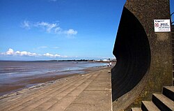
The vulnerability of the coast was highlighted on December 13, 1981, when an Atlantic storm surge and 40-knot winds overtopped defences in 22 locations. The resulting flood covered 12,500 acres, damaging over 1,000 properties and killing significant livestock. This disaster prompted a £7M investment in 1983 to build what was then Britain's largest wave return wall at Burnham-on-Sea.
Modern Flooding and Environmental Management
Despite advanced infrastructure, the region remains prone to severe flooding. Major events in 2012 and 2014 saw villages like Muchelney and Thorney cut off, requiring rescue boats and the declaration of a major incident. In 2014, the government promised a local water management plan, which included dredging the Tone and Parrett and importing giant pumps from the Netherlands.
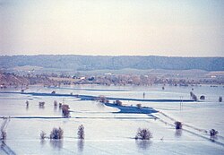
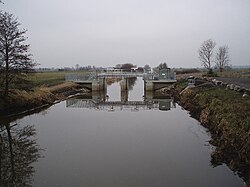
Current strategies focus on sustainability. The Parrett Catchment Partnership, involving 30 organisations, seeks a consensus on water management. One innovative approach involves the seasonal flooding of Southlake Moor; upgraded sluices allow the moor to hold 1.2 million cubic metres of water in winter to protect other areas, while providing a habitat for water birds before being drained for summer pasture.
| Feature | Purpose | Key Examples/Details |
|---|---|---|
| Rhynes | Local plot drainage | Network of small channels pumped into larger drains |
| Embankments | River containment | Southlake, Burrow, and Lake Walls |
| Pumping Stations | Water removal | Westonzoyland (est. 1830); modern electric pumps |
| Artificial Channels | Regional drainage | King's Sedgemoor Drain, Huntspill River |
| Sea Defences | Tidal protection | Burnham-on-Sea wave return wall |
Frequently Asked Questions
What are rhynes?
Rhynes are local drainage channels used to move water from agricultural plots into larger drains. They are pronounced "reens" in the east of the region and "rhyne" in the west.
Why is the River Parrett unique among the local rivers?
The Parrett is the only river in the Levels and Moors that does not have a clyse (tidal sluice), which allows the tide to enter the river unrestricted.
How did the 1981 storm affect the region?
A storm surge and high tides caused overtopping of sea defences in 22 locations, flooding 12,500 acres and causing approximately £6M in damages, which led to the construction of a major wave return wall at Burnham-on-Sea.
What is the purpose of the seasonal flooding at Southlake Moor?
It is part of a scheme to restore ten floodplains. By diverting water from the Sowy River onto the moor in winter, it can hold 1.2 million cubic metres of water to reduce flooding elsewhere and support water birds.
Who is responsible for managing the water levels today?
Water levels are managed by the Levels Internal Drainage Boards (IDBs) under the overall responsibility of the Environment Agency.