Scotia Plate: The Tectonic Bridge Between South America and Antarctica
The Scotia plate is a minor tectonic plate situated at the intersection of the South Atlantic and Southern oceans. Roughly rhomboid in shape, this plate plays a critical role in the geological connection between the southern tip of South America and the Antarctic Peninsula. Its formation and movement have not only shaped the seafloor but have had profound implications for global ocean currents and the Earth's paleoclimate.
Named after the steam yacht Scotia from the Scottish National Antarctic Expedition (1902–04)—the first to conduct bathymetric studies of the region—the plate is approximately 3,000 km long and 800 km wide. Its movement is largely dictated by the two massive plates that flank it: the Antarctic plate and the South American plate.
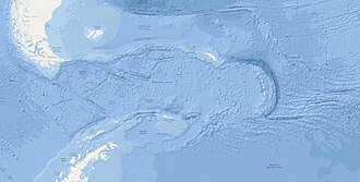
Key Facts
- Type: Minor tectonic plate.
- Approximate Area: 1,651,000 km².
- Movement: Moving West-Southwest (WSW) at a speed of 25mm/year (approximately 2.2 cm/year).
- Composition: Primarily oceanic crust with scattered continental fragments.
- Major Features: Includes the Scotia Sea, Drake Passage, and the South Georgia microcontinent.
- Formation: Originated approximately 80 million years ago, with significant development during the late Eocene.
Tectonic Setting and Boundaries
The Scotia plate, along with the South Sandwich plate, functions similarly to the Caribbean plate by joining two major continental masses. Both the Scotia and Caribbean plates feature volcanic arcs at their eastern ends and historically influenced global climate by closing major gateways between the Pacific and Atlantic Oceans.
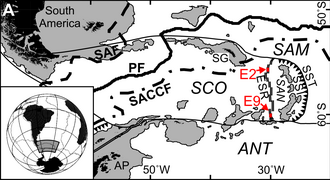
North Scotia Ridge
The northern boundary is defined by the North Scotia Ridge, a sinistral (left-lateral) transform boundary where the Scotia plate slides against the South American plate at roughly 7.1 mm/year. This ridge extends from Isla de los Estados to the South Georgia microcontinent, featuring shallow banks such as Burdwood, Davis, Barker, and Shag Rocks. To the north lies the Falkland Trough, reaching depths of 3 km.
South Scotia Ridge
The southern edge is bordered by the Antarctic plate via the South Scotia Ridge. This is also a left-lateral transform boundary, moving at a rate of 7.4–9.5 mm/year. While primarily a transform fault, some sections exhibit spreading to accommodate the boundary's irregular shape. This region includes the Powell Basin and the South Orkney microcontinent.
Shackleton Fracture Zone
The western boundary consists of the Shackleton fracture zone and the southern Chile Trench. The Chile Trench is a subduction zone where the Antarctic and Nazca plates dive beneath South America. As the subduction rate decreases southward, the motion evolves into the transform boundary of the Shackleton fracture zone. This area also contains remnants of the Phoenix plate, which was fully incorporated into the Antarctic plate by 3.3 Ma.
East Scotia Ridge
The eastern boundary is a back-arc spreading ridge known as the East Scotia Ridge. It formed as the South American plate subducted beneath the South Sandwich plate. Spreading rates here are estimated between 60 and 90 mm/year, pushing the South Sandwich Island arc eastward.
Geological Features and Evolution
The South Georgia Microcontinent
South Georgia is a fragment of continental crust with a complex history. Originally connected to the Roca Verdes back-arc basin in Tierra del Fuego, it underwent multiple cycles of burial and exhumation. It was finally uplifted approximately 10 million years ago following a collision with the Northeast Georgia Rise.
The West Scotia Ridge
Located within the plate itself, the West Scotia Ridge is an extinct spreading center created by the now-inactive Magallanes and Central Scotia plates. While most of the ridge dates to 26–5.5 Ma, some basalt samples in the W7 segment are significantly older (93–137 million years), suggesting this specific section may be a downfaulted block of the North Scotia Ridge rather than a result of seafloor spreading.
The Opening of the Drake Passage
The timing of the Scotia plate's formation is closely linked to the opening of the Drake Passage, the body of water separating South America from Antarctica. This event is scientifically significant because it led to the thermal isolation of Antarctica, facilitating the growth of the Antarctic ice sheet.
While the process began around 80 million years ago during the breakup of the Gondwana supercontinent, the Drake Passage was only a small opening with limited circulation by 50 Ma. A shift in plate motion from North-South to West-Northwest/East-Southeast, accompanied by an eightfold increase in separation speed, eventually triggered crustal thinning and the formation of the West Scotia Ridge by 30–34 Ma.
| Boundary Name | Adjacent Plate | Boundary Type | Approx. Rate |
|---|---|---|---|
| North Scotia Ridge | South American | Left-lateral Transform | 7.1 mm/yr |
| South Scotia Ridge | Antarctic | Left-lateral Transform | 7.4–9.5 mm/yr |
| East Scotia Ridge | South Sandwich | Back-arc Spreading | 60–90 mm/yr |
| Shackleton Fracture Zone | Antarctic | Transform | Variable |
Frequently Asked Questions
What is the Scotia plate?
The Scotia plate is a minor tectonic plate located between the South American and Antarctic plates, characterized by its rhomboid shape and its role in forming the Scotia Sea and Drake Passage.
How did the Scotia plate affect global climate?
The formation of the plate and the subsequent opening of the Drake Passage isolated Antarctica from warmer northern waters, which contributed to the development of the Antarctic ice sheet and shifted global paleoclimate patterns.
What is the South Georgia microcontinent?
It is a fragment of continental crust on the northeastern edge of the Scotia plate that was originally part of South America before being separated and moved eastward through tectonic activity.
What is a back-arc spreading ridge?
A back-arc spreading ridge, such as the East Scotia Ridge, is a divergent boundary that forms behind a volcanic arc (like the South Sandwich Islands) due to the subduction of an adjacent tectonic plate.
How fast is the Scotia plate moving?
The plate moves in a West-Southwest direction at a speed of approximately 25mm per year (or 2.2 cm/year).