Satellite Orbits: Comparing LEO, MEO, and GEO Systems
Modern global communication relies on a complex network of satellites positioned in specific paths around the Earth. These paths, known as orbits, are categorized primarily by their altitude and how they move relative to the Earth's surface. Depending on the mission—whether it is providing high-speed internet, GPS, or television broadcasting—engineers choose between non-geostationary orbits (NGSO) and geostationary orbits (GEO).
The choice of orbit involves a critical trade-off between coverage area, signal strength, and latency (the time delay in data transmission). While higher orbits can cover more of the planet with fewer satellites, they require more power and introduce longer delays.
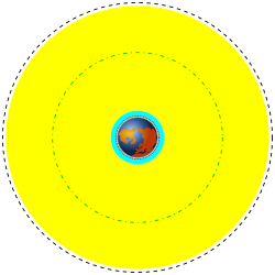
![Clickable image, highlighting medium altitude orbits around Earth,[a] from Low Earth to the lowest High Earth orbit (geostationary orbit and its graveyard orbit, at one ninth of the Moon's orbital distance),[b] with the Van Allen radiation belts and the Earth to scale](/images/f4/a3/f4a3d03c490997339c3a819e69ce1cdc204b84b2874b7f4a8022e2f990adb89d.webp)
Key Facts
- LEO (Low Earth Orbit): 160 to 2,000 km altitude; low latency, requires many satellites for continuous coverage.
- MEO (Medium Earth Orbit): 2,000 to 35,786 km altitude; a balance between coverage and signal strength.
- GEO (Geostationary Orbit): Exactly 35,786 km altitude; appears stationary from Earth, ideal for fixed antennas.
- Constellations: Groups of satellites working together to provide seamless global service.
- Specialized Orbits: Molniya orbits serve polar regions, while polar orbits are used for meteorological monitoring.
Low Earth Orbit (LEO)
Low Earth Orbit refers to the region roughly 160 to 2,000 kilometres (99 to 1,243 mi) above the Earth's surface. Satellites in LEO travel at high speeds, completing a full revolution around the planet in approximately 90 minutes.
Because they are so close to the ground, LEO satellites offer the advantage of reduced latency and require lower signal power. However, their "footprint"—the area of Earth they can see—is limited to a radius of about 1,000 kilometres (620 mi). Because they move quickly across the sky and "set" beyond the horizon, a large number of satellites are required to ensure uninterrupted connectivity.
Satellite Constellations
To overcome the limitations of a single LEO satellite, operators deploy a satellite constellation—a group of satellites working in concert. Examples include:
- Iridium: Uses 66 satellites with an orbital inclination of 86.4° to provide global phone and data services.
- Globalstar: Provides similar low-speed data and phone services to remote areas.
- Starlink: A SpaceX-operated constellation aiming for global satellite internet access.
Some systems use a "store and forward" method, where a satellite stores data while passing over one region and transmits it later over another. This is utilized by Canada's CASCADE system (via the CASSIOPE satellite) and Orbcomm.
Medium Earth Orbit (MEO)
Medium Earth Orbit occupies the space between 2,000 and 35,786 kilometres (1,243 to 22,236 mi) above the surface, with many satellites typically orbiting at around 16,000 kilometres (10,000 mi). MEO satellites function similarly to LEOs but offer a larger coverage area and longer visibility windows, usually between 2 and 8 hours.
This increased footprint means fewer satellites are needed for a network compared to LEO. The trade-off is a slightly weaker signal and longer time delay than LEO, though these are still significantly better than those found in GEO.
MEO Examples
- Telstar (1962): An early MEO satellite for high-speed telephone signals. It demonstrated that a single MEO satellite could not provide continuous coverage because its 2.5-hour orbital period did not match Earth's 24-hour rotation.
- O3b: A constellation of 20 satellites orbiting at 8,063 kilometres (5,010 mi) providing broadband internet to maritime, in-flight, and remote locations.
Geostationary Orbit (GEO)
A geostationary orbit is located exactly 35,786 kilometres (22,236 mi) above the equator. At this specific altitude, the satellite's orbital period matches the Earth's rotation rate. Consequently, the satellite appears to "stand still" in the sky from the perspective of a ground observer.
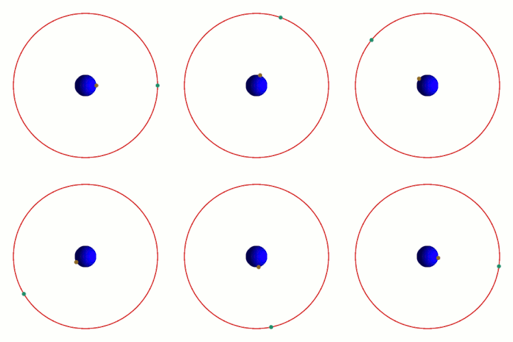
The primary advantage of GEO is that ground antennas can be fixed in one position, eliminating the need for expensive tracking equipment. This makes GEO ideal for services like DirecTV distribution.
Historical Milestones in GEO
- Syncom 3 (1964): The first geostationary satellite, used for Pacific communications and the 1964 Summer Olympics.
- Intelsat I (Early Bird, 1965): The first geostationary telecommunications satellite over the Atlantic.
- Anik A1 (1972) & Westar 1 (1974): Early continental satellites for Canada and the US, respectively.
- ATS-6 (1974): The first three-axis stabilized geostationary communications satellite.
- Satcom 1 (1975): Instrumental in the success of early cable channels (HBO, TBS, The Weather Channel) due to its high capacity of 24 transponders.
Specialized Orbital Classifications
Molniya Orbit
GEO satellites are positioned over the equator, meaning they appear very low on the horizon for users at extreme northern or southern latitudes. This can lead to connectivity issues and multipath interference, where signals reflect off the ground. To solve this, Russia developed the Molniya orbit.
The Molniya orbit is highly inclined and elliptical, ensuring the satellite spends most of its time over high northern latitudes. With a period of half a day, a constellation of three satellites can provide uninterrupted coverage for these regions.
Polar Orbit
Polar orbits are often Sun synchronous, meaning they cross the equator at the same local time every day. These are primarily used for environmental and meteorological monitoring. In the US, the National Polar-orbiting Operational Environmental Satellite System (NPOESS) manages these operations, including METSAT, EUMETSAT, and METOP.
Beyond Earth Orbit
Communication infrastructure is now expanding toward the Moon and Mars. NASA's LunaNet and the ESA's Moonlight Initiative are designing satellite constellations to provide a "Lunar Internet" and navigational services for cis-lunar spacecraft. Other proposals include placing satellites at Earth-Moon libration points or deploying the Mars Telecommunications Orbiter to support Martian surface missions.
| Orbit Type | Altitude (Approx.) | Visibility/Position | Key Advantage | Key Disadvantage |
|---|---|---|---|---|
| LEO | 160 – 2,000 km | Fast-moving / Non-stationary | Lowest latency & power | Requires many satellites |
| MEO | 2,000 – 35,786 km | Slow-moving / Non-stationary | Moderate coverage & delay | Higher power than LEO |
| GEO | 35,786 km | Stationary relative to Earth | Fixed ground antennas | Highest latency & power |
Frequently Asked Questions
Why do LEO satellites require a constellation to provide continuous service?
Because LEO satellites orbit at low altitudes, they move very quickly across the sky and have a small coverage footprint. A single satellite will soon disappear below the horizon, so a network (constellation) is needed so that as one satellite sets, another rises to take its place.
What is the main benefit of a geostationary orbit?
The main benefit is that the satellite remains in a fixed position relative to the ground. This allows ground-based antennas to be pointed at a single spot in the sky without needing expensive tracking mechanisms to follow the satellite's movement.
How does a Molniya orbit differ from a GEO orbit?
While GEO satellites stay above the equator, Molniya orbits are highly inclined and elliptical. This allows the satellite to spend the majority of its time over high northern latitudes, providing coverage to polar regions where GEO satellites are too low on the horizon to be effective.
What is the difference between LEO and MEO in terms of signal and coverage?
MEO satellites have a larger coverage area (footprint) and remain visible for longer periods (2 to 8 hours) than LEO satellites. However, because they are further away, MEO satellites have a longer time delay (latency) and weaker signals than LEO satellites.
What are Sun synchronous orbits?
Sun synchronous orbits are a type of polar orbit where the satellite crosses the equator at the same local time every day. This is particularly useful for meteorological and environmental satellites to ensure consistent lighting conditions for imagery.