San Martín Street: A Central Arterial of Rosario, Argentina
Running through the heart of Rosario in the Santa Fe Province, San Martín Street serves as a vital north-south axis for the city. Stretching 6.5 kilometers, this thoroughfare connects the scenic banks of the Paraná River to the southern edges of the urbanized area, evolving from a historic port road into a modern commercial and transit hub.
Historical Evolution
The street was not always known by its current name. Originally called Calle del Puerto (Port Street), it reflected the city's early reliance on river trade. In 1887, the name was changed to honor General José de San Martín, a celebrated hero of the Independence War.
Urban Layout and Key Zones
San Martín Street begins near the river at Belgrano Avenue, ascending toward the downtown district. As it enters the city center, the street's function shifts to accommodate pedestrians and commerce.
At the intersection with Santa Fe Street, vehicle traffic is typically restricted. One block further south, upon meeting Córdoba Street, the area transforms into a highly commercial pedestrian-only zone. This vibrant section is home to several landmark institutions, including the former Customs Office, the New Bank of Santa Fe, and the Municipal Bank. Visitors to this area will also find the Monumental film theater, various prominent hotels, and the Bernardino Rivadavia Culture Center located at Plaza Montenegro.
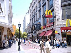
The street returns to standard vehicular traffic four blocks later at the intersection with Mendoza Street.
The Southern Commercial Core
Once the street passes south of the 27 de Febrero Boulevard, it expands into a two-way avenue with a width of 26 meters. This segment acts as the primary commercial core for Rosario's southern neighborhoods, characterized by a high density of retail stores and businesses.
The avenue eventually reaches the Beltway Avenue and the municipal boundary defined by the Saladillo Stream. Beyond this point, the road continues into the jurisdiction of the neighboring city, Villa Gobernador Gálvez.
Key Facts
- Total Length: 6.5 kilometers.
- Original Name: Calle del Puerto.
- Renamed: 1887, in honor of General José de San Martín.
- Orientation: North-south.
- Southern Width: 26 meters (as a two-way avenue).
- Key Terminus: Starts at Belgrano Avenue (Paraná River) and extends to Villa Gobernador Gálvez.
San Martín Street Overview
| Feature | Details |
|---|---|
| Location | Rosario, Santa Fe Province, Argentina |
| Pedestrian Section | Between Santa Fe St. and Mendoza St. |
| Major Landmarks | Municipal Bank, Monumental theater, Bernardino Rivadavia Culture Center |
| Southern Boundary | Saladillo Stream / Villa Gobernador Gálvez |
Frequently Asked Questions
What was San Martín Street originally called?
It was originally named Calle del Puerto (Port Street) before being renamed in 1887.
Which parts of the street are restricted to pedestrians?
The street is typically closed to traffic at Santa Fe Street and becomes a pedestrian-only commercial zone starting at the intersection with Córdoba Street, returning to normal traffic at Mendoza Street.
How long is San Martín Street in total?
The street spans a total distance of 6.5 kilometers from the coastal avenue to the southern urban limit.
What happens to the street south of 27 de Febrero Boulevard?
It becomes a 26-meter wide two-way avenue that serves as the commercial center for the southern neighborhoods of Rosario.
Where does San Martín Street end?
It reaches the municipal limit at the Saladillo Stream and Beltway Avenue, continuing into the city of Villa Gobernador Gálvez.