San Antonio Oeste: A Historic Port City of Río Negro
Located in the Argentine province of Río Negro, San Antonio Oeste serves as the head of the San Antonio department. This coastal city is defined by its strategic position near the San Matías Gulf and its evolution from a colonial outpost to a modern hub for fishing and tourism.
The city is closely linked to its sister communities: San Antonio Este to the east and the scenic cove of Las Grutas to the southwest.
History and Evolution
The region's recorded history began in 1779 when an expedition from the Spanish Empire discovered the San Matías Gulf. An outpost was established there and named San Antonio in honor of St. Anthony of Padua. However, severe water scarcity forced the original settlement to fail by 1905, prompting the community to relocate west of the gulf to the site of present-day San Antonio Oeste.
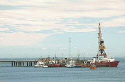
The town experienced significant growth in 1910 following the expansion of the Buenos Aires Great Southern Railway toward Bariloche. This connectivity allowed the area to develop Punta Verde, which became the primary port for Patagonia's extensive wool export industry. This economic boom lasted until the 1930s and 1940s, when a collapse in the global wool market led to the port's closure in 1944.
In the following decades, the local economy shifted toward tourism, driven by the popularity of Las Grutas and its famous grottoes. Since 2000, the city has seen a resurgence in industrial activity due to the development of a growing fishing industry, supported by the opening of a deep-water port in San Antonio Este.
Key Facts
- Established: July 10, 1905.
- Location: Río Negro Province, Argentina (40°44′S 64°57′W).
- Population: 16,265 (2010 census).
- Elevation: 3 meters (9.8 feet) above sea level.
- Climate Type: Semi-arid (BSk).
- Economy: Historically based on wool; currently driven by fishing and tourism.
Climate and Geography
San Antonio Oeste is characterized by a semi-arid climate (classified as BSk under the Köppen system), featuring hot summers and cool winters. The region is notably windy throughout the year, with mean wind speeds peaking in December at 23.1 km/h (14.4 mph).
Seasonal Patterns
- Winter: June and July are the coldest months, with a mean temperature of 8.3 °C (46.9 °F). While temperatures frequently drop below freezing, snowfall is rare, averaging only 0.2 days per year.
- Summer: January is the hottest month, with an average high of 30.2 °C (86.4 °F). During extreme heat waves from November to March, temperatures can exceed 40 °C (104.0 °F).
- Transition Seasons: Spring and autumn feature mild days and cool nights. Frosts can occur as late as November 4 in the spring and as early as March 26 in the autumn.
Precipitation is low and evenly distributed, totaling approximately 248.0 millimeters (10 inches) annually. The city enjoys significant sunshine, averaging 2,633.5 hours of bright sunshine per year.
| Metric | Winter (June/July) | Summer (January) | Annual Average/Total |
|---|---|---|---|
| Mean Temperature | ~8.3 °C (46.9 °F) | High: 30.2 °C (86.4 °F) | 14.8 °C (58.6 °F) |
| Precipitation | Moderate/Low | Low | 248.0 mm (10 in) |
| Sunshine Hours | Lowest (June) | Highest (February) | 2,633.5 hours |
| Relative Humidity | Higher | Lower | 57% |
Frequently Asked Questions
Why did the original settlement of San Antonio fail?
The original outpost established in 1779 failed by 1905 primarily due to a scarcity of water, which forced the inhabitants to move west to the current location of San Antonio Oeste.
What was the primary industry of San Antonio Oeste in the early 20th century?
The city was a major hub for the wool export industry of Patagonia, centered around the Punta Verde port, until the market collapsed in the 1930s and 1940s.
What drives the economy of the region today?
The current economy is supported by tourism in the nearby cove of Las Grutas and a growing fishing industry enabled by the deep-water port in San Antonio Este.
What is the weather like in San Antonio Oeste?
It has a semi-arid climate with hot summers, cool winters, and consistent wind throughout the year. It receives very little rainfall and experiences rare snowfall.
How does the city relate to Las Grutas and San Antonio Este?
They are sister communities; San Antonio Oeste is the administrative head, San Antonio Este provides the deep-water port infrastructure, and Las Grutas is the primary tourist destination known for its grottoes.