San Andrés and Providencia: Colombia's Caribbean Paradise
Located approximately 775 km northwest of mainland Colombia, San Andrés and Providencia is a stunning archipelago in the Caribbean Sea. Officially a department of Colombia, this region is more than just a tourist destination; it is a complex blend of diverse ethnic histories, strategic maritime geography, and breathtaking natural beauty. From the bustling streets of its capital to the quiet serenity of its outlying reefs, the archipelago serves as a vital link between South America and the Caribbean basin.
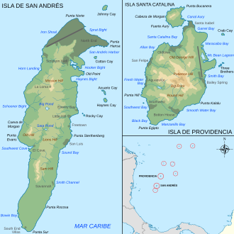
The department consists of two primary island groups and eight outlying banks and reefs. The largest island, San Andrés, serves as the administrative heart of the region, while the islands of Providencia and Santa Catalina offer a more secluded escape to the northeast.
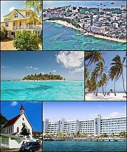
Key Facts
- Capital: North End (San Andrés City)
- Total Area: 52.5 km²
- Population: 61,280 (2018 estimate)
- GDP: COP 2,125 billion (approx. US$ 0.5 billion)
- HDI: 0.811 (Very High)
- Motto: Paraíso Turístico (Tourist Paradise)
Geography and Territory
The archipelago is characterized by its diverse topography, ranging from inhabited islands to submerged shoals. The main island of San Andrés measures 12 km in length and 3 km in width, featuring a small central lagoon known as Big Pond. Beyond the main hub, the region includes several critical atolls and banks.
The San Andrés Group
In addition to the main island, this group includes the Cayos de Albuquerque (Southwest Cays), which mark the westernmost point of Colombia. This atoll features Cayo del Norte and Cayo del Sur, with a Colombian Navy lighthouse operating on Cayo del Norte since 1980. To the east-southeast lie the Cayos del Este Sudeste (Courtown Cays), a 14 km long atoll consisting of several sand cays, including Cayo Bolivar and Cayo Arena.
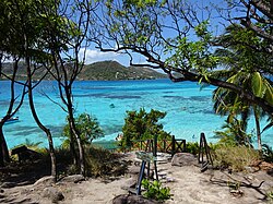
Outlying Banks and Shoals
Colombia maintains sovereignty over six additional maritime features: Alice Shoal, Bajo Nuevo Bank, Serranilla Bank, Quita Sueño Bank, Serrana Bank, and Roncador Bank. While some of these are submerged, they are strategically significant for maritime boundaries.
A Turbulent History of Sovereignty
The history of San Andrés and Providencia is a chronicle of colonial competition. Spain formally claimed the islands in 1510, but early settlement was sparse. By 1630, English Puritans established a colony on Providence Island, creating slave-worked plantations and engaging in privateering. This era of English influence was interrupted by Spanish and Portuguese conquests in 1641 and later by English buccaneers led by Henry Morgan in 1670.
In the 19th century, the islands became a focal point for independence movements. In 1818, French corsair Louis-Michel Aury captured Old Providence and St. Catherine to support Central American independence. By 1822, the inhabitants voluntarily joined the Republic of Gran Colombia.
The 20th century brought diplomatic disputes, primarily with Nicaragua. Although the 1928 Esguerra-Bárcenas Treaty granted control to Colombia, Nicaragua later repudiated the agreement. This led to a long-standing legal battle at the International Court of Justice (ICJ), which ultimately upheld Colombian sovereignty over the islands in 2007 and 2012, though some maritime border disputes remained complex.
Demographics and Culture
The human landscape of the archipelago is defined by the Raizals, an Afro-Caribbean ethnic group. Traditionally Protestant and speakers of San Andrés–Providencia Creole, the Raizals represent the indigenous Caribbean identity of the islands.
Over the decades, the demographic balance has shifted. Since 1947, the Colombian government encouraged the migration of Spanish-speaking mainlanders to the islands. This policy, supported by Catholic missions, aimed to integrate the islands more closely with the mainland. By 2005, Raizals made up approximately 30% of the population, with the remainder consisting of mainland Colombians and English-speaking whites of British descent.
Transportation and Connectivity
The primary gateway to the archipelago is the Gustavo Rojas Pinilla International Airport (ADZ). As the sixth busiest airport in Colombia, it handles the vast majority of tourists arriving from the mainland. While most visitors transit through major Colombian cities, direct international services have expanded, including flights from Panama City via Copa Airlines and nonstop service from Miami via American Airlines since 2021.
For those traveling to the smaller islands, feeder flights operate from ADZ to El Embrujo Airport on Providencia Island.
Regional Summary
| Category | Details |
|---|---|
| Administrative Status | Department of Colombia |
| Primary Islands | San Andrés, Providencia, Santa Catalina |
| Main Languages | Spanish, English, Creole |
| Key Ethnic Groups | Raizal, Mainland Colombian, British descent |
| Primary Airport | Gustavo Rojas Pinilla International (ADZ) |
Frequently Asked Questions
Who are the Raizals?
The Raizals are an Afro-Caribbean ethnic group native to the archipelago. They are traditionally Protestant and speak a unique Creole language, blending English and Caribbean influences.
Which country has sovereignty over the islands?
Colombia has sovereignty over the islands, a fact upheld by the International Court of Justice (ICJ) in rulings in 2007 and 2012, despite historical claims by Nicaragua.
How do I get to Providencia Island?
Visitors typically fly into San Andrés via Gustavo Rojas Pinilla International Airport and then take feeder flights to El Embrujo Airport on Providencia.
What is the official language of the region?
While Spanish is the official language of Colombia, the region is multilingual, with English and San Andrés–Providencia Creole widely spoken by the local population.
What are the outlying banks and shoals?
These are smaller maritime features claimed by Colombia, including Alice Shoal, Bajo Nuevo Bank, Serranilla Bank, Quita Sueño Bank, Serrana Bank, and Roncador Bank.