Santa Catalina Island: Colombia's Northernmost Outpost
Nestled in the turquoise waters of the Caribbean Sea, Santa Catalina Island serves as a serene and remote jewel of the Colombian archipelago. As the northernmost island that is politically part of South America, it offers a unique geographical position and a tranquil atmosphere far removed from the bustle of mainland cities.
Geography and Location
Santa Catalina is located at coordinates 13°23′18″N 81°22′25″W. Administratively, it falls under the jurisdiction of the Department of San Andrés, Providencia and Santa Catalina in Colombia. The island is characterized by its intimate size and its proximity to its larger neighbor.
The island is physically linked to Providencia Island to the south via a 100-metre (330 ft) footbridge, allowing for pedestrian transit between the two landmasses.
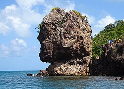
Natural Features and Climate
The coastline of Santa Catalina is defined by two primary bays: Old John Bay and Eliza Bay, which provide sheltered waters and scenic vistas.
The island experiences a dry climate, though this is punctuated by two distinct rain periods that occur annually, helping to sustain the local ecosystem.
Key Facts
- Political Status: Northernmost island politically part of South America.
- Country: Colombia.
- Department: San Andrés, Providencia and Santa Catalina.
- Population: 194 residents (as of 2018).
- Connectivity: Linked to Providencia Island by a 100-metre footbridge.
- Key Landmarks: Old John Bay and Eliza Bay.
Island Summary
| Feature | Detail |
|---|---|
| Coordinates | 13°23′18″N 81°22′25″W |
| Population (2018) | 194 |
| Climate | Dry with two annual rain periods |
| Primary Bays | Old John Bay, Eliza Bay |
| Connection | 100m footbridge to Providencia |
Frequently Asked Questions
Where is Santa Catalina Island located?
Santa Catalina Island is located in the Caribbean Sea and is part of the San Andrés, Providencia and Santa Catalina Department of Colombia.
How is the island connected to Providencia?
The island is connected to its larger sister, Providencia Island, by a footbridge measuring 100 metres (330 ft) in length.
What is the population of Santa Catalina?
As of 2018, the total population of the island was 194 people.
What are the main bays on the island?
The island features two main bays known as Old John Bay and Eliza Bay.
What is the weather like on Santa Catalina?
The island has a generally dry climate, though it experiences two periods of rain every year.