Salado River: Argentina's Vital Waterway of the North
The Salado River (Spanish: Río Salado, meaning "Salty River") is a significant waterway in Argentina, stretching 1,150 kilometres (710 mi) across several provinces. From its high-altitude origins in the Andes to its eventual confluence with the Paraná River, the Salado serves as a critical geographic and economic lifeline for the arid regions it traverses.
Due to its specific origin and the climate of the regions it crosses, the river's flow is highly variable. While it provides essential water for irrigation and human settlement, it is prone to extreme fluctuations, drying out in certain sections during the winter and causing severe flooding during rainy summers.
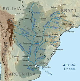
Key Facts
- Total Length: 1,150 kilometres (710 mi).
- Source: The Andes range in Salta Province (originally as the Juramento River).
- Mouth: The Paraná River in Santa Fe Province.
- Primary Tributary: The Horcones River.
- Key Infrastructure: Cabra Corral Dam and Los Figueroa Reservoir.
- Regional Importance: Acts as the economic and demographic axis for Santiago del Estero.
The Upper Course: From the Andes to the Plains
The river begins its journey on the eastern edge of the Altiplano (a high-altitude plateau) in the Salta Province. At this stage, it is known as the Juramento River. It is fed by precipitation and snowmelt from the Acay and Cachi mountains, which reach heights of 6,500 metres (21,300 ft).
To manage this water source, the Cabra Corral Dam regulates the flow and diverts water for agricultural irrigation. As the river descends from the mountains and enters the Gran Chaco plains, the landscape changes, and the riverbed widens, often splitting into several arms that only partially fill the broad channel.
The Heart of Santiago del Estero
Upon entering the Santiago del Estero Province from the north, the waterway officially takes the name Salado. Along with the Dulce River (the "Sweet River"), the Salado runs diagonally southeast, serving as the primary water source for the province's arid lands.
Water management in this region is handled by the Los Figueroa Reservoir and a Derivation Dam (Dique Derivador), which feeds irrigation canals extending up to 200 kilometres (120 mi). The river's behavior here is seasonal: during summer high waters, it creates expansive marsh wetlands. However, downstream of the Añatuya marshlands, the flow diminishes significantly, leaving the river dry for much of the year.
The Lower Salado and the Paraná Confluence
After traveling 800 kilometres (500 mi) through Santiago del Estero, the river enters the Santa Fe Province, where it is referred to as the Salado del Norte ("Northern Salty"). In this region, increased rainfall boosts the river's discharge.
While the increased water is beneficial, it also poses risks. During heavy summer rains, the river frequently overflows. A notable example occurred in 2003, when severe flooding heavily impacted the city of Santa Fe. The Salado eventually concludes its journey by flowing into the Paraná River southeast of Santa Fe City, merging into a landscape characterized by lagoons and floodplains.
Comparison of Salado Rivers in Argentina
Because "Salado" simply means "Salty," several other rivers in Argentina share this name. While the Northern Salado is the most prominent, others include:
| River Name/Region | Location (Provinces) | Approximate Length/Destination |
|---|---|---|
| Río Salado (Buenos Aires) | Buenos Aires | 650 km (400 mi) to Samborombón Bay |
| Desaguadero-Salado | Mendoza, San Luis, La Pampa | Flows into the Colorado River |
| Salado River (La Rioja) | Catamarca, La Rioja | Local name for the Colorado River |
Frequently Asked Questions
Why is the river called the Salado River?
The name "Salado" is Spanish for "Salty," referring to the salinity of the water in certain sections of the river.
What is the relationship between the Juramento River and the Salado River?
The Juramento River is the original name of the Salado River at its source in the Andes mountains of Salta Province before it enters the plains and becomes the Salado.
How does the river affect the economy of Santiago del Estero?
The Salado and Dulce rivers act as the economic and demographic axis of the province, providing essential water for irrigation via dams and canals in an otherwise arid region.
Is the Salado River prone to flooding?
Yes, particularly in the Santa Fe Province. Increased summer rainfall can cause the river to overflow its banks, as seen during the severe floods of 2003 in Santa Fe City.
Does the Salado River flow year-round?
No. Because of its origin and the arid climate it passes through, the flow varies widely. Some parts of the river can dry out completely during the winter months.