Saint Peter and Saint Paul Archipelago: Brazil's Remote Atlantic Outpost
Located in the heart of the central equatorial Atlantic Ocean, the Saint Peter and Saint Paul Archipelago (Portuguese: Arquipélago de São Pedro e São Paulo) is a collection of 15 small islets and rocks. This remote outpost is the only Brazilian oceanic territory situated in the Northern Hemisphere, positioned within the Intertropical Convergence Zone—a region known for low average winds and frequent local thunderstorms.
Despite its small size, the archipelago holds immense strategic and scientific value for Brazil. It is administratively part of the state of Pernambuco, specifically within the special state district of Fernando de Noronha, though it lies hundreds of miles away from both.
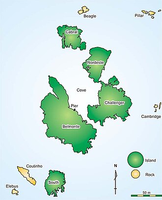
Key Facts
- Total Area: Approximately 1.5 hectares (3.7 acres).
- Highest Point: 17 meters (56 ft) on Nordeste Island.
- Composition: 15 islets and rocks, including five major islets: Belmonte, Challenger, Nordeste, Cabral, and South.
- Administration: Managed by Brazil; permanently staffed by the Brazilian Navy since 1998.
- Geological Uniqueness: The only location in the Atlantic where the abyssal mantle is exposed above sea level.
A History of Accidental Discovery and Exploration
The archipelago was discovered by accident on April 20, 1511, by a Portuguese fleet led by Captain Garcia de Noronha. During a nighttime journey to India, the caravel Saint Peter crashed into the rocks; the crew was subsequently rescued by the caravel Saint Paul, giving the islets their name.
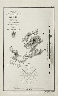
Over the centuries, the rocks became a waypoint for famous explorers. In 1832, Charles Darwin visited during the first leg of the HMS Beagle's voyage. He noted the complete absence of plants or lichens, viewing the rocks as a model for how life first colonizes new land. Other notable visitors include American captain Amasa Delano (1799), James Clark Ross (1839), and explorer Ernest Shackleton (1921–1922).
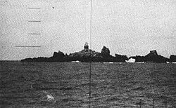
In the 20th century, the islets gained modern notoriety. In 1960, they served as the starting and ending point for the first submerged circumnavigation of the globe by the American nuclear-powered submarine USS Triton.
The Brazilian Navy Scientific Station
Since June 25, 1998, the Brazilian Navy has operated the Saint Peter and Saint Paul Archipelago Scientific Station (ECASPSP). The facility is staffed by four researchers who rotate every 15 days. This permanent presence is critical for Brazil, as it extends the nation's Exclusive Economic Zone (EEZ), territorial waters, and airspace into the North Atlantic.
The station has faced significant challenges. In 2006, a magnitude 6.0 earthquake triggered a tidal surge that flooded the original facility, forcing researchers to seek shelter in the lighthouse. In response, a new, larger station was constructed between 2007 and 2008, featuring seismic isolation, a reverse osmosis desalination system, and photovoltaic power.
The Navy also maintains a lighthouse (ARLHS: SPP-001), built in 1995, with a focal light positioned 29 meters above average sea level to ensure maritime safety in the region.
Geography and Geology
The archipelago consists of several rocks and islets, with the largest being Belmonte Islet (5,380 square meters). While the peaks are low, their base extends over 3,650 meters below sea level.
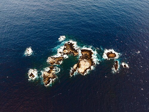
Geologically, the islets are a rarity. Unlike most oceanic islands, they are not volcanic. Instead, they were formed by tectonic uplift. They expose serpentinized abyssal mantle peridotite and ultramafic mylonite. This site represents the world's second-largest megamullion, a massive geological structure of deformed rock.
Undersea Morphology
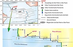
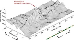
The archipelago sits on the junction between the South American and African plates, specifically atop the Peridotitic Chain of São Pedro and São Paul. This underwater elevation is roughly 100 km long and 3,800 meters high. The surrounding area is one of the deepest parts of the Atlantic, with some depths exceeding 5,000 meters, characterized by the São Paulo Transform Fault System.
Biodiversity and Environment
Designated as an environmentally protected area in 1986, the archipelago is a sanctuary for marine life. The surrounding waters are home to over 100 species of reef fish, approximately 10% of which are endemic (found nowhere else), such as the colorful Tosanoides aphrodite.
Terrestrial life is sparse. Darwin's early records noted boobies, brown noddies, crabs, and various parasitic insects. Today, the primary economic activity in the surrounding waters is tuna fishing.
| Feature | Detail |
|---|---|
| Coordinates | 00°55′1″N 29°20′45″W |
| Total Islets | 15 |
| Major Islets | Belmonte, Challenger, Nordeste, Cabral, South |
| Highest Elevation | 17 m (Nordeste Islet) |
| Geologic Origin | Tectonic Uplift (Abyssal Mantle) |
| Primary Activity | Scientific Research & Tuna Fishing |
Frequently Asked Questions
Why is the archipelago important to Brazil?
Beyond scientific research, the permanent occupation of the islets allows Brazil to extend its Exclusive Economic Zone (EEZ), territorial waters, and airspace further into the North Atlantic Ocean.
Are the islands volcanic?
No. Unlike many oceanic islands, these were formed by geologic uplift of the abyssal mantle, a fact first noted by Charles Darwin in 1832.
Who lives on the islands?
There is no permanent civilian population. The islands are staffed by four Brazilian Navy researchers who rotate every 15 days.
What happened to Air France Flight 447?
On June 1, 2009, the aircraft crashed into the Atlantic Ocean near the archipelago. Fragments of the plane and bodies were recovered just northwest of the islets.
What makes the geology here unique?
It is the only place in the Atlantic Ocean where the abyssal mantle is exposed above sea level, featuring serpentinized peridotite and a massive megamullion structure.