Rosario Municipal Districts: Decentralizing Urban Governance
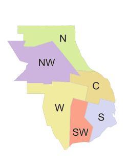
The city of Rosario, located in the province of Santa Fe, Argentina, employs a strategic system of administrative divisions known as municipal districts. These districts were established to decentralize the workings of the municipal government, ensuring that essential services and administrative tasks are distributed more evenly across the urban landscape.
Historically, the city's commercial, cultural, and administrative activities were concentrated within a small area of approximately five square kilometers known as the microcentro. This concentration centered heavily on the Palacio de los Leones (the municipal building), forcing citizens to travel long distances into a crowded downtown area. This model often overwhelmed the capacity of municipal personnel and facilities.
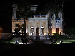
To break this center-vs.-periphery model, the Municipality of Rosario launched an ambitious program to bring government closer to its citizens. This initiative began in 1997 with the opening of the first Municipal Center at Villa Hortensia, a historic mansion in the northern barrio of Alberdi.
Key Facts
- Six Districts: Rosario is divided into six administrative zones to improve service accessibility.
- Decentralization Goal: The system aims to distribute administrative, cultural, and health services away from the crowded microcentro.
- CMD Hubs: Centros Municipales de Distrito (CMD) serve as one-stop shops for citizens.
- Integrated Services: CMDs host municipal, provincial, and utility company delegations in one location.
- Historical Shift: The program officially started in 1997 at Villa Hortensia.
Municipal District Centers (CMD)
The Centros Municipales de Distrito (CMD) are multi-functional hubs designed to handle a wide array of citizen needs. Each center is structured into three primary functional areas:
- Administrative Services Area: Handles general requests, communication with the municipal government, and real estate records.
- Urban Development Area: Manages city planning and infrastructure needs.
- Socio-cultural and Health Services Area: Provides community health and cultural programming.
Beyond these core areas, the CMDs host various external delegations to streamline bureaucracy. These include the Municipal Bank, the Civil Register (for services such as civil marriages), the Provincial Tax Administration, and essential utility providers including the Empresa Provincial de la Energía (power), Aguas Santafesinas (water), and Litoral Gas (natural gas).
As of 2006, five active CMDs were operational: the North District Center (Villa Hortensia), the West District (Felipe Moré), the Northwest District (Olga y Leticia Cossettini), the South District (Rosa Ziperovich), and the Center District (Antonio Berni).
District Demographics and Geography
While most districts are named based on their geographic location, the eastmost division is designated as the Center District because it encompasses the oldest part of the city, historically referred to as the Centro.
The following data, based on the 2001 INDEC census, provides a detailed look at the population and land distribution across the six districts:
| District | Population | Area (km²) | % of Municipality | Density (inh/km²) | Housing Units |
|---|---|---|---|---|---|
| Center | 261,047 | 20.37 | 11.45% | 12,815 | 110,152 |
| North | 131,495 | 35.02 | 19.6% | 3,744 | 40,492 |
| Northwest | 144,461 | 44.14 | 24.7% | 3,273 | 41,740 |
| West | 106,356 | 40.21 | 22.5% | 2,645 | 31,625 |
| Southwest | 103,446 | 20.19 | 11.3% | 5,123 | 28,284 |
| South | 160,771 | 18.76 | 10.5% | 8,569 | 48,541 |
Frequently Asked Questions
Why did Rosario divide the city into municipal districts?
The division was created to decentralize municipal government operations, reducing the reliance on the crowded microcentro and bringing administrative, cultural, and health services closer to the citizens in their own neighborhoods.
What services are available at a Centro Municipal de Distrito (CMD)?
CMDs provide administrative services (real estate records, general requests), urban development, and socio-cultural and health services. They also host delegations for the Municipal Bank, Civil Register, Provincial Tax Administration, and utility companies for power, water, and gas.
Which district is the most densely populated?
Based on 2001 census data, the Center District is the most densely populated, with 12,815 inhabitants per square kilometer.
When did the decentralization program begin?
The program was first put into practice in 1997 with the opening of the Municipal Center at Villa Hortensia in the North District.
Which district covers the largest geographic area?
The Northwest District is the largest, covering 44.14 square kilometers, which represents 24.7% of the municipality.