Potosí: Bolivia's High-Altitude Hub of Mining and Natural Wonders
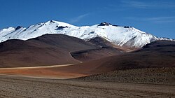
Located in the southwestern region of Bolivia, Potosí (known as P'utuqsi in Quechua and Putusi in Aymara) is a department defined by its dramatic landscapes and immense mineral wealth. Spanning 118,218 square kilometers, this mostly barren, mountainous territory is home to some of the most striking geological features on Earth, including a vast western plateau and the world's largest salt flat.
From its historical role as a cornerstone of the Spanish Empire to its modern-day significance in the global energy transition, Potosí remains a region of critical economic and cultural importance to Bolivia.
Key Facts
- Capital: Potosí
- Population: 856,419 (2024 census)
- Total Area: 118,218 km²
- Primary Languages: Quechua, Spanish, and Aymara
- Major Landmark: Salar de Uyuni (the world's largest salt flat)
- Economic Drivers: Silver, zinc, lead, and lithium mining
Geography and Natural Landmarks
The landscape of Potosí is characterized by high altitudes and rugged terrain. To the west lies a massive plateau that hosts the Salar de Uyuni, a prehistoric lake bed that has become one of Bolivia's most famous tourist destinations and a vital source of lithium.
Beyond the salt flats, the region is home to the Eduardo Avaroa Andean Fauna National Reserve, which protects unique ecosystems and vibrant high-altitude lakes.
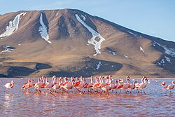
Notable points of interest include the colorful Laguna Colorada, Laguna Verde, and Laguna Blanca, as well as the Torotoro National Park. The region's volcanic activity is evidenced by landmarks such as Cerro Lipez, a stratovolcano (a conical volcano built up by many layers of hardened lava and tephra).
Economic Powerhouse: From Silver to Lithium
Historically, Potosí was the wealthiest province in the Spanish Empire. The silver extracted from Cerro Potosí provided a massive percentage of the precious metal shipped to Europe during the colonial era.
Mining continues to drive the local economy today. The San Cristóbal mines produce silver, zinc, and lead; these were developed by the US-based Apex Silver Mines Limited before being sold to the Japanese Sumitomo Corporation in November 2008. More recently, the focus has shifted toward the Salar de Uyuni's lithium deposits.
The importance of these resources has occasionally led to social unrest. In March 2023, social organizations and lawmakers called for a 72-hour strike to demand increased infrastructure investment and a larger share of profits from lithium mining. This resulted in an agreement with the central government to build a cement plant and new motorways.
Government and Administration
Potosí is governed by an elected governor and a Departmental Legislative Assembly. Since May 2010, the chief executive has held the title of governor, replacing the previous role of "prefect." The current administration is led by Jhonny Mamani of the Movement for Socialism – Political Instrument for the Sovereignty of the Peoples (MAS-IPSP), though Marco Gutiérrez has served as acting governor during Mamani's detention.
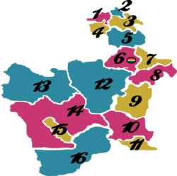
Administratively, the department is divided into 16 provinces, which are further subdivided into 40 municipalities and 219 cantons.
| Category | Detail |
|---|---|
| Total Area | 118,218 km² |
| Population (2024) | 856,419 |
| GDP (2023) | US$ 1.8 billion (Int$ 4.2 billion PPP) |
| HDI (2019) | 0.631 (Medium) |
| Time Zone | UTC-4 |
Demographics and Culture
The population of Potosí has seen steady growth, rising from 657,743 in 1976 to 856,419 by 2024. The region is a linguistic crossroads, with Quechua being the most spoken language (514,421 speakers), followed by Spanish (438,204) and Aymara (57,738).
The department is also the birthplace or home of several notable figures, including the guerrilla military leader Juana Azurduy de Padilla, Manuel Ascencio Padilla, and the writer and politician Modesto Omiste Tinajeros.
Frequently Asked Questions
What is the most famous landmark in Potosí?
The most famous landmark is the Salar de Uyuni, which is recognized as the largest salt flat in the world.
Which minerals are primarily mined in the region?
Potosí is renowned for its silver, zinc, and lead mining, and it is currently a critical site for lithium extraction.
What languages are spoken in Potosí?
The primary languages spoken are Quechua, Spanish, and Aymara.
Who is the current governor of Potosí?
Jhonny Mamani is the elected governor, though Marco Gutiérrez has served as the acting governor.
How is the department administratively divided?
Potosí is divided into 16 provinces, 40 municipalities, and 219 cantons.