Peru Geography and Environmental Landscape
Peru is a megadiverse country located in the Western and Southern Hemispheres of the Americas. Situated within Latin America on the continent of South America, Peru is characterized by its vast ecological variety and dramatic topographical shifts, ranging from the depths of the Pacific Ocean to the highest peaks in the tropics.
With a total area of 1,285,220 km² (496,230 sq mi), Peru stands as the 19th largest country in the world. Its strategic position along the South Pacific Ocean and its shared borders with five neighboring nations make it a central hub of South American geography.
Key Facts
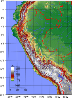
- Highest Point: Huascarán, reaching 6,768 m (22,205 ft), the highest point in the Tropics.
- Lowest Point: South Pacific Ocean at 0 m.
- Total Land Boundaries: 7,461 km.
- Coastline: 2,414 km along the South Pacific Ocean.
- Population: 28,750,770 (as of June 30, 2007), ranking it as the 44th most populous country.
- Time Zone: UTC-05.
Physical Geography and Natural Features
The landscape of Peru is defined by extreme contrasts. The country's geology is marked by significant activity, including a history of earthquakes and the presence of the Peru–Chile Trench off its coast.
Mountains and Water Systems
Peru's terrain is dominated by diverse mountains and volcanoes. Its hydrological network is equally complex, featuring numerous rivers, waterfalls, and lakes. The country also hosts glaciers and fjords, contributing to its status as a megadiverse environment.
Biodiversity and Environment
The environmental makeup of Peru includes a wide array of natural regions, protected areas, and biosphere reserves. This biodiversity is evident in its rich flora and fauna, particularly its diverse populations of birds and mammals. The country also manages various national parks to preserve these critical ecosystems.
Administrative Divisions and Regions
Peru is organized into a structured hierarchy of administrative divisions to manage its vast territory. The capital city is Lima.
The country is divided into 25 regions and the province of Lima. These regions further break down into provinces, districts, and municipalities, which serve as the primary populated centers of the nation.
The 25 Regions of Peru
- Amazonas, Ancash, Apurímac, Arequipa, Ayacucho, Cajamarca, Callao, Cusco, Huancavelica, Huánuco, Ica, Junín, La Libertad, Lambayeque, Lima, Loreto, Madre de Dios, Moquegua, Pasco, Piura, Puno, San Martín, Tacna, Tumbes, and Ucayali.
Bordering Nations
Peru shares extensive land boundaries totaling 7,461 km. The distribution of these borders is as follows:
| Neighboring Country | Boundary Length (km) |
|---|---|
| Brazil | 2,995 |
| Colombia | 1,800 |
| Ecuador | 1,420 |
| Bolivia | 1,075 |
| Chile | 171 |
Frequently Asked Questions
What is the highest point in Peru?
The highest point is Huascarán, which stands at 6,768 m (22,205 ft) and is the highest point in the Tropics.
How many regions is Peru divided into?
Peru is divided into 25 regions and the province of Lima.
Which countries border Peru?
Peru is bordered by Brazil, Colombia, Ecuador, Bolivia, and Chile.
What is the total area of Peru?
Peru covers an area of 1,285,220 km² (496,230 sq mi), making it the 19th largest country in the world.
What is the time zone in Peru?
Peru operates on the UTC-05 time zone.