Penns Neck History: From Quaker Land Grants to West Windsor Settlement
The story of Penns Neck is a narrative of early colonial expansion and the establishment of enduring community roots in New Jersey. Spanning a 6,500-acre tract, this region evolved from a strategic land purchase by a founding father into a flourishing settlement defined by its unique geography and familial legacies.
The Colonial Foundations of Penns Neck
The land that would eventually be known as Penns Neck was first acquired from the East Jersey Board of Proprietors by William Penn, the Quaker founder of Pennsylvania. In 1737, the land transitioned to new ownership when Garret Schenck and John Covenhoven purchased the tract from Penn's sons. This period marked the formal beginning of the area's recorded history.
The year 1737 is significant as it is the first time the name "Penns Neck"—named in honor of William Penn—appears in records. During this time, the area was also referred to by an alternate name, "Williamsborough." The settlement was established by the Schenck and Covenhoven families, bounded by natural landmarks: the Stony Brook to the west, the Millstone River to the north, the Assunpink Creek to the south, and Penn Lyle Road to the east.
Growth and Community Development
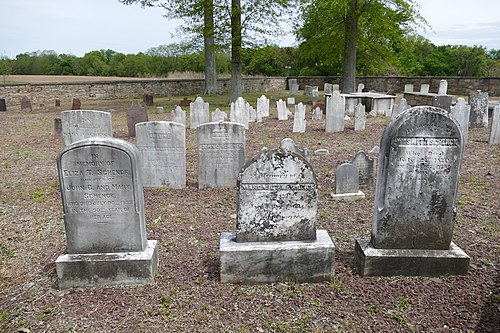
As the settlement took root in the late 1730s and 1740s, the settlers established the Schenck-Covenhoven cemetery to serve the growing community. This site remains a testament to the first wave of settlement in West Windsor.
The Impact of Infrastructure
The trajectory of Penns Neck changed significantly with the development of regional transportation. The chartering of the Brunswick Pike (now known as Route 1) began in 1804 and reached completion in 1807. This new artery of travel allowed the community to flourish, leading to the construction of the Red Lion Inn, which served as a hub for travelers and locals alike.
The Spiritual and Geographic Heart
In 1812, the community further solidified its center with the erection of the Princeton Baptist Church, also known as the Penns Neck Baptist Church. The church's location helped establish the intersection of Route 1 and Washington Road as the historical and geographical heart of the Penns Neck community.
Key Facts
- Original Acreage: The tract consisted of 6,500 acres.
- Original Owner: Purchased from the East Jersey Board of Proprietors by William Penn.
- Primary Settlers: Garret Schenck and John Covenhoven purchased the land in 1737.
- Alternate Name: The area was once called "Williamsborough."
- Key Infrastructure: Brunswick Pike (Route 1) was completed in 1807.
- Historical Landmarks: Includes the Red Lion Inn and the Princeton Baptist Church (est. 1812).
| Category | Details |
|---|---|
| Founding Year | 1737 |
| Northern Boundary | Millstone River |
| Southern Boundary | Assunpink Creek |
| Western Boundary | Stony Brook |
| Eastern Boundary | Penn Lyle Road |
| Key Date | 1807 (Completion of Brunswick Pike) |
For those interested in further exploration, the Historical Society of West Windsor launched an online museum in October 2019, providing a digital archive of the history of West Windsor and the Penns Neck area.
Frequently Asked Questions
Who were the first settlers of Penns Neck?
The area was settled by the Schenck and Covenhoven families, specifically Garret Schenck and John Covenhoven, who purchased the land from William Penn's sons in 1737.
What was the original name of Penns Neck?
While named after William Penn, the area was also known by the alternate name "Williamsborough" during its early years.
How did the construction of Route 1 affect the community?
The completion of the Brunswick Pike (Route 1) in 1807 caused the community to flourish, leading to the construction of the Red Lion Inn and increasing regional connectivity.
Where is the historical center of Penns Neck located?
The geographical and historical heart of the community is centered at the intersection of Route 1 and Washington Road, anchored by the Princeton Baptist Church.
What are the natural boundaries of the original Penns Neck tract?
The tract was bordered by the Millstone River to the north, Assunpink Creek to the south, Stony Brook to the west, and Penn Lyle Road to the east.