Pellegrini Avenue: A Central Arterial Road of Rosario
Located in the heart of Rosario, Santa Fe Province, Pellegrini Avenue (Avenida Pellegrini) serves as a vital east-west artery. Stretching from the banks of the Paraná River to the western edge of the urbanized area, this two-way avenue is more than just a transit route; it is a defining boundary of the city's downtown district, alongside the river and Oroño Boulevard.
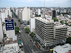
The avenue is characterized by its two wide lanes and a narrow central reservation, which is typically landscaped with bushes and small trees. As it begins near the Paraná River, the road ascends toward the city center via grassy slopes and elevated sidewalks. To the east of this starting point lies the scenic Parque Urquiza.
Urban Landscape and Landmarks
As Pellegrini Avenue reaches the level of the central city, it passes several significant institutional and commercial landmarks. It hosts the massive complex of the National University of Rosario's School of Engineering and its affiliated Politécnico secondary school.
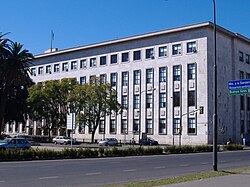
Further west, the avenue transforms into a vibrant commercial hub. This stretch is renowned for its high density of dining options, including fine restaurants, canteens, bars, pizza parlours, and ice cream shops. A few blocks further west, the avenue passes the Tribunals of Rosario, the city's judicial center.
One of the most significant intersections on the avenue is its meeting point with Oroño Boulevard. This junction marks one of the corners of the Parque de la Independencia, which stands as the largest green space in the city.
Connectivity and History
Beyond its role as a local street, Pellegrini Avenue is a primary arterial road providing essential access to Rosario from the west. After traversing the city, the avenue transitions directly into the Rosario–Córdoba Highway, linking the city to the broader regional infrastructure.
The avenue has a rich history dating back to the 19th century. It was inaugurated in 1868 under the name Bulevar Argentino. This project was part of a municipal beautification program launched six years after the municipality's creation, at a time when Rosario had a population of approximately 23,000 residents. This program also saw the opening of Oroño Boulevard, originally known as Bulevar Santafesino. The street was later renamed in honor of Carlos Pellegrini, who served as the President of Argentina from 1890 to 1892.
Key Facts
- Location: Rosario, Santa Fe Province, Argentina.
- Orientation: East-west axis.
- Original Name: Bulevar Argentino (inaugurated 1868).
- Named After: Carlos Pellegrini (President of Argentina, 1890–1892).
- Major Connection: Becomes the Rosario–Córdoba Highway at the western limit.
- Key Landmarks: Parque Urquiza, School of Engineering (UNR), Rosario Tribunals, and Parque de la Independencia.
| Feature | Details |
|---|---|
| Route | Paraná River to the western urban limit |
| Configuration | Two-way avenue with central reservation |
| Primary Function | Arterial road and western city access |
| Historical Context | Part of 1868 municipal beautification program |
Frequently Asked Questions
Where does Pellegrini Avenue begin and end?
The avenue begins near the shores of the Paraná River in the east and extends to the western limit of Rosario's urbanized area, where it becomes the Rosario–Córdoba Highway.
What is the historical significance of the avenue's name?
Originally called Bulevar Argentino, it was renamed to honor Carlos Pellegrini, who served as the President of Argentina between 1890 and 1892.
Which major parks are located along or near the avenue?
Parque Urquiza is located to the east of the avenue's starting area, and the intersection with Oroño Boulevard marks a corner of the Parque de la Independencia, the city's largest green area.
What can visitors find in the commercial section of the avenue?
The commercial stretch of the avenue is known for its wide variety of eateries, including fine restaurants, bars, pizza parlours, and ice cream shops.
What educational institutions are located on Pellegrini Avenue?
The avenue passes the School of Engineering of the National University of Rosario and its affiliated Politécnico secondary school.