National Route 3: Argentina's Epic Journey to the End of the World
National Route 3 (Ruta Nacional 3) is one of Argentina's most vital arteries, stretching across the eastern side of the country. This massive highway connects the bustling capital of Buenos Aires with the southernmost reaches of the continent, serving as a lifeline for trade, tourism, and regional connectivity.
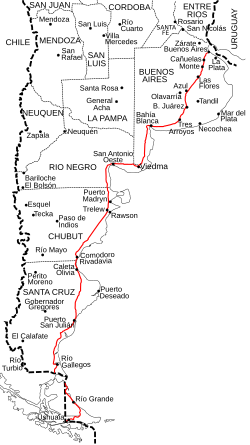
Spanning a total distance of 3,045 kilometres (1,892 mi), the route begins at Avenida General Paz (A001) in Buenos Aires and traverses five provinces: Buenos Aires, Río Negro, Chubut, Santa Cruz, and Tierra del Fuego. The journey concludes at the bridge over the Lapataia River in Tierra del Fuego.
Key Facts
- Total Length: 3,045 kilometres (1,892 mi).
- Starting Point: Avenida General Paz, Buenos Aires.
- Ending Point: Lapataia River bridge, Tierra del Fuego.
- Provinces Crossed: Buenos Aires, Río Negro, Chubut, Santa Cruz, and Tierra del Fuego.
- International Transit: Requires passage through Chile to reach Tierra del Fuego.
The Route and Regional Geography
The highway is not a continuous stretch of Argentine pavement. Between kilometre 2674 and 2696, the road is interrupted by the Magellan Strait. To continue south from Santa Cruz to Tierra del Fuego, travelers must enter Chile and utilize Ruta CH-255 and Ruta CH-257. This detour includes 57 kilometres of paved road north of the strait and 148 kilometres of paved and treated road to the south.
The crossing of the Magellan Strait itself is handled by a ferry, traversing a width of 4.65 kilometres (2.89 mi) in approximately twenty minutes.
The Comandante Luis Piedrabuena Section
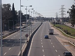
A specific portion of the highway holds a distinct designation. Under National Decree 1931 of 3 August 1983, the section of the road south of National Route 22, beginning at the kilometre 719 marker, was named Comandante Luis Piedrabuena.
Provincial Breakdown and Major Hubs
National Route 3 serves as the primary link for numerous cities and towns. Below is the detailed progression from north to south.
Buenos Aires Province
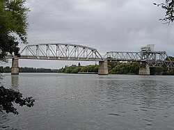
Covering 949 kilometres (590 mi) from marker 14 to 963, this section passes through several key districts (Partidos), including La Matanza (San Justo, González Catán), Cañuelas, Azul, and Bahía Blanca, providing essential access to the Port of Ingeniero White.
Río Negro Province
This 339-kilometre (211 mi) stretch (km 963-1304) connects the city of Viedma and provides access to San Antonio Oeste and Sierra Grande.
Chubut Province
Extending 552 kilometres (343 mi) from marker 1304 to 1856, the route provides access to Puerto Madryn and Rawson, while passing directly through Trelew, Comodoro Rivadavia, and Rada Tilly.
Santa Cruz Province
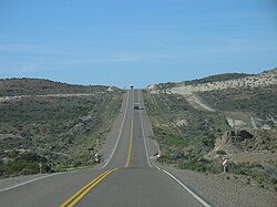
The route covers 818 kilometres (508 mi) from marker 1856 to 2674. Major stops include Caleta Olivia, Comandante Luis Piedrabuena, and Río Gallegos, before reaching the Chilean border at kilometre 2674.
Tierra del Fuego Province
The final 363-kilometre (226 mi) leg (km 2696-3059) begins at Hito 1. It passes through Río Grande and Tolhuin, finally reaching the city of Ushuaia.
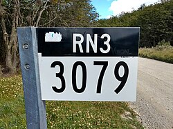
Route Summary Table
| Province | Length (km) | Kilometre Range | Key Cities/Points |
|---|---|---|---|
| Buenos Aires | 949 | 14 – 963 | Bahía Blanca, Azul, Cañuelas |
| Río Negro | 339 | 963 – 1304 | Viedma |
| Chubut | 552 | 1304 – 1856 | Trelew, Comodoro Rivadavia |
| Santa Cruz | 818 | 1856 – 2674 | Caleta Olivia, Río Gallegos |
| Tierra del Fuego | 363 | 2696 – 3059 | Río Grande, Ushuaia |
Tolls and Administration
In 1990, the Argentine government transferred the maintenance of high-traffic roads to private companies via "Corredores Viales" (road corridors). Initially, the company Semacar managed Corridor 1 (km 19 to 677), with tolls located in Cañuelas, Azul, and Tres Arroyos.
Following the expiration of these contracts in 2003, a new bidding process occurred. The updated Corridor Vial 1 was awarded to "Empresa Rutas al Sur," covering the stretch from kilometre 62 (Provincial Route 6 in Cañuelas) to kilometre 677 (National Route 252 in Grünbein).
Frequently Asked Questions
How long is National Route 3?
The highway is 3,045 kilometres (1,892 mi) long.
Does the road go directly from Santa Cruz to Tierra del Fuego?
No, the road is interrupted by the Magellan Strait. Travelers must pass through Chile via Ruta CH-255 and Ruta CH-257 and take a ferry to cross the strait.
How long does the ferry crossing at the Magellan Strait take?
The ferry crosses a distance of 4.65 kilometres (2.89 mi) and typically takes twenty minutes.
Which cities are located at the northern and southern ends of the route?
The route starts in Buenos Aires and ends in Ushuaia, Tierra del Fuego.
Who currently manages the toll sections in the Buenos Aires province?
Following the 2003 contract renewals, the section from kilometre 62 to 677 was managed by Empresa Rutas al Sur.