National Route 9: Argentina's Vital Arterial Highway
National Route 9 (Spanish: Ruta Nacional 9) is one of Argentina's most critical transportation arteries. Stretching from the center-east to the northwest, this massive highway spans 1,967 km (1,222 mi), connecting the bustling hub of Buenos Aires with the Bolivian border. It serves as a lifeline for commerce and travel, traversing seven provinces: Buenos Aires, Santa Fe, Córdoba, Santiago del Estero, Tucumán, Salta, and Jujuy.
The route begins at Avenida General Paz, the boundary between the Autonomous City of Buenos Aires and its surrounding province, and concludes at the Horacio Guzmán International Bridge over the La Quiaca River. While much of the route varies in design, the stretch from Buenos Aires to Rosario is developed as a limited-access motorway.
Key Facts
- Total Length: 1,967 km (1,222 mi).
- Termini: From Avenida General Paz (Buenos Aires) to the Horacio Guzmán International Bridge (La Quiaca).
- Provinces Crossed: Buenos Aires, Santa Fe, Córdoba, Santiago del Estero, Tucumán, Salta, and Jujuy.
- Historical Root: Based on the colonial "Camino Real del Perú" (Royal Road of Peru).
- Major Hubs: Connects major cities including Rosario, Córdoba, and San Miguel de Tucumán.
Historical Evolution
From Colonial Trails to Railroads
The origins of Route 9 date back to the colonial era as the Camino Real del Perú. This royal road was the primary means of travel from Buenos Aires to Potosí and Peru, passing through Córdoba, Santiago del Estero, Tucumán, Salta, and Jujuy. To support travelers, a network of inns was established every 30–50 km. For a time, it shared a path with the "Camino Real del Oeste," which branched off toward Chile.
The road's importance declined in the late 19th century with the rise of the railroad. Trains offered faster, weather-resistant transport, culminating in the first train reaching La Quiaca on December 30, 1907.
The Rise of the Automobile
With the advent of cars, the Federal Government pivoted back to road construction. In 1936, the path from Buenos Aires to La Quiaca was officially designated as National Route 9. Although it was fully open to traffic by 1943, the majority of the route remained unpaved at that time.
Over the following decades, the highway began to reclaim the cargo and passenger traffic previously held by the railroads. This shift eventually led to the decline of rail service to the north, with the last passenger train to La Quiaca arriving in December 1993 and the final cargo train in July 1994.
Pavement and Infrastructure Development
Early Paving Efforts
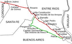
The initial paving phase saw the Buenos Aires to Rosario section completed by December 27, 1936, with the road reaching Córdoba by June 5, 1937. Interestingly, the original layout differed from today's path, traversing through Pilar to Pergamino via what is now National Route 8 before turning north toward Rosario.
The early stretch between Plaza Congreso in Buenos Aires and San Martín Square in Córdoba spanned 768 km (477 mi), featuring 42 bridges and 1,412 sewer covers, costing 41 million pesos moneda nacional (approximately 12 million USD at the time).
Modernizing the Route
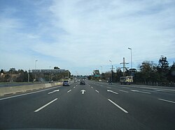
In 1943, the layout was optimized to shorten the distance between Argentina's two most populous cities by incorporating sections of Route 12. Full paving from Buenos Aires to Rosario was achieved by 1956. The final remaining unpaved section, located north of Humahuaca in Jujuy Province, was completed between 1997 and 2004, officially opening to the public on January 21, 2005.
Divided Lanes and Motorways
The Buenos Aires - Rosario Corridor
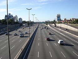
The section from Greater Buenos Aires to the Port of Campana is part of the Acceso Norte (North Access), a 120 km road. A specific segment from Avenida General Paz to the start of Route 8 is known as the "Autopista Pascual Palazzo." The highway was expanded in stages, reaching Garín in 1959, Campana in 1971, and Zárate in 1977. The section between San Nicolás de los Arroyos and Rosario, named "Teniente General Juan José Valle," was opened in 1978, with the final gap between Campana and the Tala River closed in 1987.
The Rosario – Córdoba Highway
Planned since 1970, the Rosario–Córdoba highway was designed to divert through-traffic away from town centers and the Ferrocarril General Bartolomé Mitre railroad. Construction occurred in fragmented stages through various concession contracts in the 1990s and 2000s. Following several bidding processes involving companies like Benito Roggio e Hijos, IECSA, and DYCASA, the highway was fully inaugurated on December 22, 2010.
Regional Adjustments and Right-of-Way
In 1979, Decree 1595 reorganized several routes, transferring certain sections to provincial jurisdiction. In Greater Buenos Aires, a 15 km section in Tigre Partido became Provincial Route 9. Between San Nicolás de los Arroyos and Rosario, old sections were transferred to become Provincial Route 098–06 and Provincial Route 21.
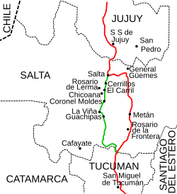
Significant changes also occurred in the north. In Salta Province, a 104 km mountain section was transferred to become Provincial Route 6, while a 79 km stretch became National Route 68. Additionally, the section shared with National Route 34 in Salta was upgraded to a four-lane road during the 2000s.
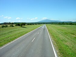
Route Summary by Province
| Province | From | To | Length | Major Cities/Points |
|---|---|---|---|---|
| Buenos Aires | km 12 | km 237 | 225 km | Campana, Zárate, San Nicolás de los Arroyos |
| Santa Fe | km 237 | km 419 | 182 km | Villa Constitución, Rosario, Cañada de Gómez |
| Córdoba | km 419 | km 910 | 491 km | Bell Ville, Villa María, Córdoba |
| Santiago del Estero | km 910 | km 1223 | 313 km | Santiago del Estero, Termas de Río Hondo |
| Tucumán | km 1223 | km 1371 | 148 km | San Miguel de Tucumán |
| Salta | km 1371 | km 1648 | 277 km | Rosario de la Frontera, General Güemes, Salta |
| Jujuy | km 1648 | km 1979 | 318 km | San Salvador de Jujuy, Humahuaca, La Quiaca |
Frequently Asked Questions
Where does National Route 9 start and end?
The route begins at Avenida General Paz on the border of the Autonomous City of Buenos Aires and ends at the Horacio Guzmán International Bridge at the Bolivian border in La Quiaca.
What was the historical predecessor to Route 9?
The highway follows the path of the colonial "Camino Real del Perú" (Royal Road of Peru), which was used for centuries to travel from Buenos Aires toward Potosí and Peru.
Which sections of the road are motorways?
The section from Buenos Aires to Rosario is a limited-access motorway, and the Rosario–Córdoba stretch was fully inaugurated as a highway on December 22, 2010.
When was the entire length of the road finally paved?
While most of the road was paved by the mid-20th century, the final section north of Humahuaca in Jujuy Province was completed in 2004 and opened to the public on January 21, 2005.
Which provinces does National Route 9 traverse?
It crosses seven provinces: Buenos Aires, Santa Fe, Córdoba, Santiago del Estero, Tucumán, Salta, and Jujuy.