Manchurian Mixed Forests: A Biodiversity Hotspot of East Asia
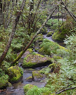
Spanning the rugged terrain of northern China, Russia, North Korea, and South Korea, the Manchurian mixed forests ecoregion represents a vital ecological transition zone. This vast landscape of forested hills surrounds river plains, creating a unique environment where mountains meet wetlands. Because the region is bordered by mountains on three sides, it serves as a critical refuge for a diverse array of flora and fauna, many of which are rare due to the area's relative isolation.
Key Facts
- Total Area: 504,828 km² (194,915 mi²)
- Climate Type: Humid continental (Dwb) with warm summers and dry winters
- Primary Biome: Temperate broadleaf and mixed forests
- Conservation Status: 11% (57,139 km²) is currently under protection
- Key Species: Siberian tiger, Amur leopard, and Ussuri brown bear
Geography and Landscape
The ecoregion is defined by its middle-elevation slopes, nestled within three major mountain ranges. It occupies the eastern slopes of the Greater Khingan Mountains, the southern slopes of the Lesser Khingan, and the western slopes of the Changbai Mountains.
The geography is structured in distinct sections:
- Southern Section: Surrounds the higher-elevation Changbai Mountains mixed forests.
- Middle Section: Encircles the lower-elevation Northeast China Plain deciduous forests.
- Northern Section: Surrounds the lower western sector of the Amur meadow steppe.
Climate Patterns
The region experiences a humid continental climate, specifically classified under the Köppen system as Dwb. This means the area undergoes significant seasonal temperature shifts, characterized by warm summers and cold, dry winters.
In this climate, at least four months average over 10 °C (50 °F), though no single month averages above 22 °C (72 °F). Precipitation typically ranges between 500 and 1000 mm per year, with the wettest periods occurring during the summer and fall. During the winter, monthly precipitation levels drop to less than one-tenth of the wettest summer month.
Flora: A Mix of Conifers and Deciduous Trees
Because the ecoregion spans latitudes from 37 to 53 degrees north, the vegetation shifts from the deciduous-heavy forests of the south to more conifer-dominated forests in the north. This mix of species is what gives the ecoregion its name.
Common Conifers
On the eastern side, the landscape is dominated by Korean pine (Pinus koraiensis), Manchurian fir (Abies holophylla), and Siberian spruce (Picea obovata). On the western side, the Scots pine (Pinus sylvestris) is a common sight.
Deciduous Species
The broadleaf component of the forest includes several hardy species, such as the Mongolian oak (Quercus mongolica), Manchurian ash (Fraxinus mandschurica), Amur linden (Tilia amurensis), and Manchurian elm (Ulmus laciniata).
Fauna: Rare and Endangered Wildlife
The diverse habitats provided by the mixed forests support a wide range of wildlife. The region is a stronghold for several large mammals and predators.
Notable inhabitants include:
- Large Predators: The endangered Siberian tiger (Panthera tigris tigris) and the Amur leopard (Panthera pardus orientalis).
- Bears: The Ussuri brown bear (Ursus arctos lasiotus) and the Ussuri black bear (Ursus thibetanus ussuricus).
- Ungulates: Manchurian wapiti (Cervus canadensis xanthopygus) and Manchurian sika deer (Cervus nippon mantchuricus).
- Other Wildlife: Wolves, red foxes, wild boar, and the common raccoon dog.
Conservation and Protected Areas
Protecting this ecoregion is a significant challenge, as very little forest remains outside of designated zones. A 2017 assessment indicated that approximately 11% of the ecoregion, or 57,139 km², is currently within protected areas.
Key protected sites include:
- China: Heishan, Huazishan, Jiguan Mountain, Laozumu Peak, Menggu Mountain, Wanfo Mountain, Xiangmoshan, and Xinglong National Forest Parks.
- Russia: Land of the Leopard National Park.
- South Korea: Seoraksan National Park.
Summary of Ecoregion Characteristics
| Feature | Details |
|---|---|
| Realm | Palearctic |
| Biome | Temperate broadleaf and mixed forests |
| Countries | China, Russia, North Korea, South Korea |
| Coordinates | 47°45′N 128°45′E |
| Precipitation | 500 to 1000 mm/year |
Frequently Asked Questions
What kind of climate does the Manchurian mixed forest have?
The region has a humid continental climate (Dwb), which features warm summers and cold, dry winters with significant seasonal temperature variations.
Which endangered animals live in this ecoregion?
The ecoregion is home to the endangered Siberian tiger and the Amur leopard.
What are the main types of trees found here?
The forest is a mix of conifers, such as Korean pine and Siberian spruce, and deciduous trees, such as Mongolian oak and Manchurian ash.
How much of the Manchurian mixed forest is protected?
As of a 2017 assessment, approximately 11% of the ecoregion (57,139 km²) is located within protected areas.
Where is this ecoregion located geographically?
It is located in East Asia, covering the forested hills surrounding river plains in China, Russia, North Korea, and South Korea.