Main River: Germany's Vital Waterway and the Rhine's Longest Tributary
The Main is one of Europe's most significant rivers and serves as the longest tributary of the Rhine. Flowing entirely within German borders, it stretches approximately 525 kilometers (326 miles) from its origins in the Fichtel Mountains of northeastern Bavaria to its confluence with the Rhine near Rüsselsheim in Hesse. As a critical artery for transport and culture, the Main connects major urban centers and plays a pivotal role in European inland navigation.
The river is most famous for passing through the financial hub of Frankfurt am Main, as well as the cities of Offenbach and Würzburg. Beyond its economic utility, the Main serves as a geographical and cultural marker, historically delineating the northern border of Southern Germany.
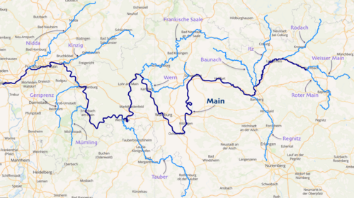
Key Facts
- Total Length: 524.9 km (326.2 mi).
- Basin Size: 27,208 km².
- Source: Formed by the confluence of the Red Main and White Main in Upper Franconia.
- Mouth: Discharges into the Rhine near Mainz and Wiesbaden.
- Navigability: Navigable for 396 km from the Rhine to Bamberg.
- Strategic Link: Part of European "Corridor VII," linking the North Sea to the Black Sea via the Rhine-Main-Danube Canal.
Geography and Course
The Main begins near Kulmbach in Franconia, where two headstreams meet: the Red Main (Roter Main), which originates in the Franconian Jura and flows through Bayreuth, and the White Main (Weißer Main), which rises in the Fichtel Mountains at an elevation of 895 meters.
The river's basin is of particular scientific interest; its upper end opposes that of the Danube, forming the European Watershed—a divide recognized by hydrologists and biologists as the boundary between drainage systems flowing toward different seas.
As it flows west, the Main traverses the German Highlands before crossing the Lower Main Lowlands. Along its journey, it is fed by several major tributaries, including the Regnitz, the Franconian Saale, the Tauber, and the Nidda.
Navigation and Infrastructure
The Main is a highly engineered waterway designed for commercial shipping. To accommodate CEMT class V vessels (ships measuring up to 110 x 11.45 meters), the river has been canalized with 34 large locks. Since 1992, the river has been linked to the Danube via the Rhine-Main-Danube Canal, creating a continuous navigable path across the European continent.
Navigation requires significant skill in the upper reaches where the river is narrower, particularly for push convoys and larger vessels heading toward the inland ports surrounding Frankfurt.
Weirs and Hydroelectric Power
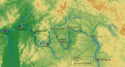
The 380 km navigable section from Bamberg to the Rhine is managed by 34 weirs and locks. Most of these structures are utilized for hydroelectric power generation, with many employing Kaplan turbines to generate electricity. The operator E.ON Wasserkraft manages a significant portion of these plants, while the Wasser- und Schifffahrtsamt Aschaffenburg oversees others near the mouth.
| Feature | Detail |
|---|---|
| Source Elevation | 895 m (Weissmainquelle) |
| Mouth Elevation | 83 m |
| Average Discharge | 200 m³/s |
| Number of Locks | 34 |
| Lock Dimensions | 300 x 12 m |
| Major Cities | Frankfurt, Offenbach, Würzburg |
Cultural and Recreational Significance
The Main is more than a commercial route; it is a cultural boundary. The "Main line" is often viewed as the divide between Northern and Southern Germany, specifically marking the transition to predominantly Catholic regions. Linguistically, the river corresponds with the Speyer line isogloss, separating Central and Upper German dialects (sometimes referred to as the Weißwurstäquator).
For tourists and outdoor enthusiasts, the Main-Radweg (Main Cycle Path) is a premier attraction. Stretching approximately 600 kilometers from Creußen or Bischofsgrün to Mainz, it was the first long-distance path to receive a 5-star rating from the General German Bicycle Club (ADFC) in 2008.
Frequently Asked Questions
Where does the Main River start?
The Main begins in Upper Franconia, Bavaria, at the confluence of the Red Main (originating in the Franconian Jura) and the White Main (originating in the Fichtel Mountains).
How is the Main connected to the Danube?
The Main is connected to the Danube via the Rhine-Main-Danube Canal and the regulated Altmühl river, allowing ships to travel from the North Sea to the Black Sea.
What are the largest cities located along the river?
The largest cities on the Main are Frankfurt am Main, Offenbach am Main, and Würzburg.
What is the European Watershed?
The European Watershed is the hydrological divide located at the upper end of the Main basin, separating the river systems that flow into the North Sea (via the Rhine) from those that flow into the Black Sea (via the Danube).
Is the Main River navigable for large ships?
Yes, the river is navigable for 396 km from its mouth to Bamberg. It features 34 locks designed to accommodate CEMT class V vessels.