German Postal Codes: Evolution and Structure of the PLZ System
The Postleitzahl (PLZ), or postal code, is a fundamental component of the German logistics infrastructure. While today it is a seamless five-digit numeric system, its journey from a simple two-digit parcel identifier to a sophisticated geographic tool reflects the complex political and social history of Germany.
The Evolution of the German Postal System
The formal introduction of postal codes in Germany occurred on July 25, 1941. Initially, this was a two-digit system used exclusively for parcel services before expanding to all mail deliveries. As the country divided following World War II, the systems diverged.
In 1962, West Germany adopted a four-digit system. East Germany followed suit three years later with its own four-digit version. Interestingly, the Federal Republic (West Germany) intentionally left certain number ranges—specifically those starting with '1' (except for West Berlin's 1000) and '9'—vacant to accommodate a potential future reunification. In contrast, the German Democratic Republic (East Germany) utilized the full range from '1' to '9' for its own internal needs.
Following reunification, a transitional period occurred between 1990 and 1993. During this time, former West German codes were prefixed with the letter "W" and East German codes with "O" (for Ost, meaning east). However, the government decided that a completely new system was necessary for the 1990s to modernize delivery.
The current five-digit system, implemented in 1993, solved several legacy issues. It allowed larger cities to be divided into multiple postal code areas and enabled high-volume mail recipients, such as mail-order businesses, to have their own private codes. This change removed the old convention where the number of trailing zeros indicated the size of a city (for example, 2000 for Hamburg or 8000 for Munich).
How the Modern PLZ System Works
The modern system is organized hierarchically based on geography. The first digit represents the Postleitzone (postal zone), and the second digit represents the Postleitregion (postal region). For example, the digit '1' identifies North East Germany, while '10' specifically denotes a zone within Berlin's inner city.
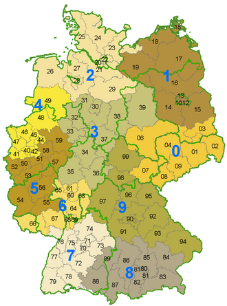
This geographic distribution means that some federal states are contained entirely within a single postal zone, such as Saxony, Saarland, and Schleswig-Holstein, as well as the city-states of Berlin, Bremen, and Hamburg. Other states, including Lower Saxony, Saxony-Anhalt, and Baden-Württemberg, are more expansive and cover four different postal zones.
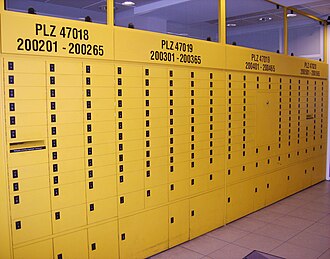
Beyond residential addresses, the system extends to post office boxes. These are organized in racks containing dozens of boxes, with each individual rack identified by its own specific postal code.
Regional Distribution and Demographics
As of December 31, 2007, the postal zones were distributed across the country as follows:
| Leitzone | Area (km²) | Population | Region Covered | Major Cities |
|---|---|---|---|---|
| 0 | 37,187.8 | 6,819,607 | Saxony, southern Saxony-Anhalt/Brandenburg, eastern Thuringia | Dresden, Leipzig, Halle, Chemnitz, Cottbus, Jena |
| 1 | 47,642.4 | 7,034,541 | Berlin, Brandenburg, Mecklenburg-Vorpommern, parts of Lower Saxony/Saxony-Anhalt | Berlin, Potsdam, Frankfurt (Oder), Rostock, Schwerin |
| 2 | 44,207.4 | 8,691,409 | Hamburg, Schleswig-Holstein, northern Lower Saxony, Bremen, parts of Mecklenburg-Vorpommern | Hamburg, Lübeck, Kiel, Bremen, Bremerhaven, Oldenburg |
| 3 | 45,488.1 | 9,012,212 | Southern Lower Saxony, eastern Westphalia, northern Hesse, Thuringia, Saxony-Anhalt | Hanover, Bielefeld, Kassel, Fulda, Gießen, Göttingen, Brunswick, Magdeburg |
| 4 | 20,212.3 | 10,331,535 | North-western North Rhine-Westphalia, south-western Lower Saxony | Düsseldorf, Dortmund, Essen, Duisburg, Bochum, Wuppertal, Münster |
| 5 | 28,834.5 | 9,233,815 | South-western North Rhine-Westphalia, Rhineland-Palatinate, parts of Hesse | Cologne, Bonn, Aachen, Mainz, Koblenz, Trier |
| 6 | 17,247.9 | 7,540,503 | Southern Hesse, Rhineland-Palatinate, Saarland, parts of Bavaria/Baden-Württemberg | Frankfurt (Main), Wiesbaden, Darmstadt, Saarbrücken, Heidelberg, Mannheim |
| 7 | 27,864.2 | 8,715,898 | Baden-Württemberg, parts of Rhineland-Palatinate | Stuttgart, Karlsruhe, Tübingen, Freiburg, Konstanz, Baden-Baden |
| 8 | 36,427.2 | 7,675,001 | Southern Bavaria, south-eastern Baden-Württemberg | Munich, Rosenheim, Augsburg, Ulm, Ingolstadt |
| 9 | 47,803.7 | 7,163,416 | Northern Bavaria (Franconia), Thuringia, parts of Baden-Württemberg | Nuremberg, Würzburg, Erfurt, Weimar, Eisenach, Bamberg, Bayreuth |
Key Facts
- Current Format: Five numeric digits since 1993.
- Structure: The first digit is the Postleitzone (zone) and the second is the Postleitregion (region).
- Historical Roots: The first formal system began in 1941 with two digits.
- Reunification: Between 1990 and 1993, codes were prefixed with "W" (West) or "O" (East).
- Special Assignments: Large companies can be assigned their own private postal codes.
Frequently Asked Questions
When did Germany start using postal codes?
Germany introduced its first postal code system on July 25, 1941, starting as a two-digit system for parcels before expanding to all mail.
What does the first digit of a German postal code represent?
The first digit represents the Postleitzone, which is a broad geographic zone. For example, '1' covers North East Germany.
Why did Germany change to a five-digit system in 1993?
The change allowed for a more precise division of large cities into multiple areas and enabled high-volume mail recipients to have their own private codes, replacing an inconsistent system of adding numbers after city names.
How were postal codes handled immediately after German reunification?
From 1990 to 1993, the existing four-digit codes were used but prefixed with "W" for the former West Germany and "O" for the former East Germany.
Do postal zones align perfectly with state borders?
Not always. While some states like Saxony and Saarland lie entirely within one zone, others like Lower Saxony and Baden-Württemberg span across four different postal zones.