Loch Ness: Geography, History, and the Legends of the Scottish Highlands
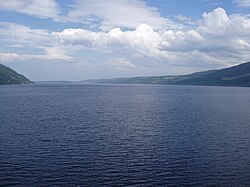
Loch Ness is one of Scotland's most iconic landmarks, situated in the Scottish Highlands southwest of Inverness. While world-famous for the mystery of its elusive inhabitant, the loch is a geographical marvel of the British Isles, characterized by its immense depth and vast volume of freshwater.
Extending approximately 37 kilometers (23 miles) from southwest to northeast, the loch is the second-largest in Scotland by surface area. However, it holds the title of the largest loch by volume in the British Isles, containing more water than all the lakes in England and Wales combined.
Key Facts
- Maximum Depth: 226.96 meters (744.6 feet).
- Water Volume: 7.5 cubic kilometers (1.8 cubic miles).
- Surface Area: 56 square kilometers (21.8 square miles).
- Primary Outflow: The River Ness.
- Key Landmark: Urquhart Castle.
- Unique Feature: Largest volume of freshwater in the British Isles.
Geography and the Caledonian Canal
Loch Ness is an oligotrophic (low in nutrients) and dimictic (mixing twice a year) freshwater loch. Its surface sits 15.8 meters (52 feet) above sea level, a level that was raised by approximately 1.2 meters during the construction of the Caledonian Canal.
The Caledonian Canal, engineered by Thomas Telford in the early nineteenth century, spans 60 miles to connect the east coast at Inverness with the west coast at Corpach. Loch Ness forms a significant natural portion of this waterway, alongside Loch Dochfour, Loch Oich, and Loch Lochy.
Cherry Island
At the southwestern end of the loch lies Cherry Island (Scottish Gaelic: Eilean Muireach). This is a crannog—an artificial island likely built during the Iron Age. Historically, it hosted a stone and oak castle in the 15th century, serving as a fortified refuge or potentially a hunting lodge.
Local Settlements and Infrastructure
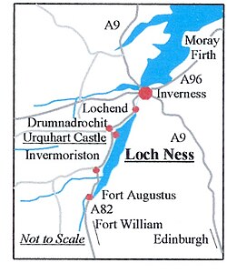
The loch is surrounded by several small villages and key sites. The A82 road follows the western shore, connecting Inverness to Fort William and passing through Drumnadrochit and Invermoriston.
| Shore Location | Key Places |
|---|---|
| Northern | Lochend |
| Western | Abriachan, Drumnadrochit, Urquhart Castle, Invermoriston |
| Eastern | Dores, Inverfarigaig, Foyers, Whitebridge |
| Southern | Fort Augustus |
Safety and navigation are managed by lighthouses at Lochend and Fort Augustus. Notably, the northern shore near Drumnadrochit hosts an RNLI lifeboat station, established in 2008 as the first non-coastal station for the organization.
Etymology and Folklore
The name Loch Ness is derived from the River Ness, which flows from the loch's northern end. The word "Ness" likely stems from an old Celtic term meaning "roaring one." Local legends offer more mystical origins, including a tale of a druid's enchanted spring that overflowed to create the loch, and stories from the Ulster Cycle of Irish mythology involving the tragic love of Deirdre and Noais.
The Loch Ness Monster
The loch is globally renowned as the home of "Nessie," a cryptid (an animal whose existence is claimed but not scientifically proven). While popular interest peaked after 1933, scientific surveys have yielded varied results. In 2007, a sonar survey discovered a common toad at a depth of 98 meters, dubbed the "Loch Ness Toad."
Hydroelectricity and Ecology
Loch Ness is a vital resource for renewable energy. It serves as the lower reservoir for the 300MW Foyers pumped-storage scheme (opened 1975) and is near the 100MW Glendoe Hydro Scheme. Several new projects are proposed, including the Loch na Cathrach project and the 2 GW Glean Earrach Energy scheme. However, the Ness District Salmon Fisheries Board has expressed concerns regarding the ecological impact of these developments.
The loch supports a variety of fish species, including the Atlantic salmon, Arctic char, European eel, and Northern pike. While the European sea sturgeon is known in the connected Beauly-Moray Firth, its presence in the loch remains unconfirmed.
Modern History and Records
The loch has been the site of remarkable events, including the 1939 ditching of a Royal Air Force Vickers Wellington Bomber. The aircraft remained submerged until 1976, when it was rediscovered by sonar operators searching for the monster. It was raised in 1985 and is now displayed at the Brooklands Museum.
Athletes have also tested their limits here. Brenda Sherratt became the first person to swim the length of the loch in 1966, taking over 31 hours. In 2026, Ewan McConachie set a Guinness World Record for water skiing from Fort Augustus to Loch End beach in 32 minutes and 15 seconds.
Frequently Asked Questions
How deep is Loch Ness?
The maximum depth of Loch Ness is 226.96 meters (744.6 feet), making it the second deepest loch in Scotland.
What is Cherry Island?
Cherry Island is an artificial Iron Age island, known as a crannog, located at the southwestern end of the loch.
Does Loch Ness contain more water than other UK lakes?
Yes, due to its extreme depth, Loch Ness is the largest loch by volume in the British Isles, containing more water than all the lakes in England and Wales combined.
What is the purpose of the Caledonian Canal?
The Caledonian Canal connects the east coast of Scotland at Inverness with the west coast at Corpach, using Loch Ness as one of its primary natural waterways.
What fish live in Loch Ness?
The loch is home to several species, including Atlantic salmon, sea trout, brown trout, Arctic char, European eel, and Northern pike.